
Alps to Ocean Cycle Trail facts for kids


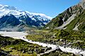
The Alps 2 Ocean Cycle Trail is an amazing bike path in New Zealand. It's one of the longest trails in the country! You can ride your bike for over 300 kilometres (190 mi) (that's about 186 miles). The trail starts near Aoraki / Mount Cook, New Zealand's highest mountain. It ends in Oamaru, a cool town right by the Pacific Ocean. This trail is easy to ride and great for all ages. It has both paved roads and special off-road paths.
What can you see on the trail?
- Aoraki / Mount Cook: New Zealand's tallest mountain.
- Snowy mountains and golden tussock grasslands.
- Beautiful glacier lakes like Lake Pukaki and Lake Ōhau.
- Huge hydro canals and dams that make electricity.
- Native forests with unique trees.
- Cool rock formations like Elephant Rocks.
- Ancient Maori rock art.
- Places where you can find old fossils from a "Vanished World."
- Fun towns with shops, museums, and art galleries.
- Steampunk HQ in Oamaru, a super creative art space.
- A blue penguin colony in Oamaru, where you can see tiny penguins!
The Alps 2 Ocean Cycle Trail was planned as part of the bigger New Zealand Cycle Trail project. Funding for the trail was approved in July 2010. Many people thought this trail would bring great opportunities for tourism to the Waitaki Valley area.
Contents
Sections of the Alps 2 Ocean Trail
The trail is split into eight main parts. As you ride from west to east, you go from high up in the mountains (780 metres (2,560 ft)) all the way down to the sea!
Aoraki/Mt Cook to Braemar Station
This first part is about 32 kilometres (20 mi) long. It starts on a special bike path, perfect for mountain bikes. Then it goes onto a quiet gravel road. This section is quite remote, so you might need to cross some small streams without bridges. There aren't many places to stay at Braemar Station, so some riders combine this with the next section.
Braemar Station to Twizel
This 43 kilometres (27 mi) section continues on gravel roads over some hills. You'll ride along the southern side of Lake Pukaki. You'll also see parts of the hydro-electric system that uses water to make power. As you get closer to Twizel, the path becomes paved. Twizel is the biggest town you'll find on the trail until you reach Oamaru.
Twizel to Lake Ohau
The third section is 38 kilometres (24 mi) long. It's the only part where you go slightly uphill overall. You'll follow canals that are part of the hydro-electric system. These canals connect the big glacial lakes. A special bike path goes around the southern shore of Lake Ōhau. This section finishes on a paved road near the Lake Ohau Lodge.
Lake Ohau to Omarama
This part of the trail is on a dedicated bike path. You'll ride through old beech forests. This section has the biggest changes in height. You'll climb about 400 metres (1,300 ft) along the Ohau Range. This takes you to the highest point on the whole trail, over 900 metres (3,000 ft) above sea level! Then you'll ride downhill for about 40 kilometres (25 mi) to finish in Omarama.
Omarama to Otematata
This section is 24 kilometres (15 mi) long. The first half goes over the Omarama Saddle on a special bike path next to State Highway 83. The second half of this section is on the state highway itself.
Otematata to Kurow
This 44 kilometres (27 mi) section continues into the Waitaki Valley. You'll ride on paved public roads. You'll also see some huge dams like Benmore Dam, Aviemore Dam, and Waitaki Dam. These dams are part of the Waitaki hydro-electric power system. A new 16 kilometres (9.9 mi) off-road section opened in late 2020. It goes from Sailors Cutting to the top of the Benmore Dam. This new part offers great views of Lake Benmore.
Kurow to Duntroon
From Kurow, the trail continues off-road for 23 kilometres (14 mi) to Duntroon. This area is famous for its cool limestone rock shapes. You can also see ancient Maori rock drawings and dinosaur fossils from the "Vanished World."
Duntroon to Oamaru
The last section partly follows the Vanished World trail. You'll ride past the famous Elephant Rocks. This part uses a mix of paved back roads and special bike paths. From Weston, the trail follows an old railway line. It enters Oamaru through the Oamaru Gardens. The trail finishes after 55 kilometres (34 mi) at Friendly Bay. This is right next to Oamaru's historic Victorian area.
Images for kids
-
From Alps...
-

...to (a historic town by the) Ocean.
