Waitaki River facts for kids
Quick facts for kids Waitaki |
|
|---|---|

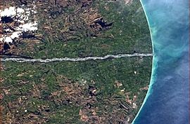
Lower Waitaki River pictured from the International Space Station
|
|

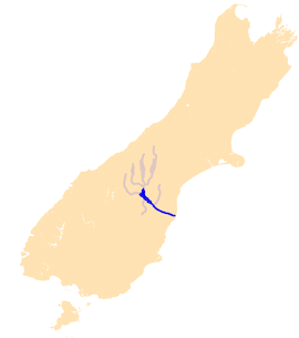
The Waitaki River system
|
|
| Country | New Zealand |
| Region | Canterbury, Otago |
| District | Waimate, Waitaki |
| Cities | Otematata, Kurow, Duntroon, Glenavy |
| Physical characteristics | |
| Main source | Southern Alps Lake Benmore, New Zealand 44°21′S 170°12′E / 44.350°S 170.200°E |
| River mouth | Pacific Ocean New Zealand 0 m (0 ft) 44°57′S 171°09′E / 44.950°S 171.150°E |
| Length | 209 km (130 mi) |
| Basin features | |
| Tributaries |
|
The Waitaki River is a big, wide river in New Zealand. It flows for about 110 kilometres (68 mi) from the Mackenzie Basin to the Pacific Ocean. You can find it on the east coast of the South Island, between the towns of Timaru and Oamaru.
The river starts where the Ōhau River and the Tekapo River meet. These rivers get their water from three large lakes fed by glaciers: Pukaki, Tekapo, and Ōhau. The Waitaki River then flows through three artificial lakes: Lake Benmore, Lake Aviemore, and Lake Waitaki. These lakes were made by building large dams.
The Waitaki River has several smaller rivers that flow into it, like the Ahuriri River and the Hakataramea River. It passes through towns such as Kurow and Glenavy before reaching the ocean.
The amount of water in the river changes throughout the year. In winter, the flow is usually low. It gets much higher in spring when the snow on the Southern Alps melts. During summer, the flow depends on how much rain falls. In autumn, it goes down again as the weather gets colder and smaller streams freeze. The average flow of the Waitaki River at Kurow is about 356 cubic metres per second (12,600 cu ft/s).
People enjoy the Waitaki River for fun activities. It's a popular spot for fishing and jetboating.
Making Electricity from the River
The Waitaki River is very important for making hydroelectricity in New Zealand. This is electricity made using the power of moving water. Many projects have been built along the river to do this.
The first dam, called the Waitaki dam, was built between 1928 and 1934. It was built without modern earth-moving machines! After that, the Aviemore Dam was built, creating Lake Aviemore. Then came the Benmore Dam, which formed Lake Benmore.
The water from these power stations flows back into the Waitaki River. This creates a storage lake for the next power station in the chain.
Here are the main power stations on the lower Waitaki River:
- Waitaki (started in 1935): It can make 105 MW of power and produces 500 GWh each year.
- Benmore (started in 1965): This is a big one, making 540 MW and 2200 GWh annually.
- Aviemore (started in 1968): It produces 220 MW and 940 GWh each year.
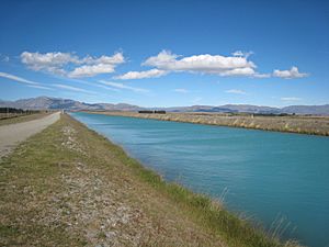
In the 1960s, work began on the "Upper Waitaki project." This project involved a clever system of canals and more power stations. Water from the original Tekapo (A) station goes through the Tekapo Canal. It then reaches Tekapo B station, which is near Lake Pukaki. The dam at Lake Pukaki was made taller to hold more water.
Water from Lake Pukaki then travels through the Pukaki Canal. This canal joins the Ohau Canal from Lake Ōhau. The combined water flows to Ohau A station and into Lake Ruataniwha. The Ohau Canal continues past Lake Ruataniwha to Ohau B, and then through Ohau C, finally emptying into Lake Benmore.
Here are the power stations in the Upper Waitaki project:
- Tekapo A (started in 1955): Makes 25 MW and 160 GWh annually.
- Tekapo B (started in 1977): Makes 160 MW and 800 GWh annually.
- Ohau A (started in 1980): Makes 264 MW and 1150 GWh annually.
- Ohau B (started in 1984-85): Makes 212 MW and 970 GWh annually.
- Ohau C (started in 1984-85): Also makes 212 MW and 970 GWh annually.
Future Plans for the River
In 2001, a company called Meridian Energy suggested building new canals and dams. This plan, called Project Aqua, aimed to use a lot of the lower river's water for irrigation and more electricity. However, these plans were stopped in March 2004. The main reason was that it wasn't going to make enough money. Also, many people protested against the project.
A smaller plan, called the North Bank tunnel, seemed like it might happen. They even got permission to use the water in 2009. But in 2013, talks about getting access to the land stopped. This was because they predicted that people wouldn't need as much electricity in the next five years.
 | Jewel Prestage |
 | Ella Baker |
 | Fannie Lou Hamer |


