Southern Alps / Kā Tiritiri o te Moana facts for kids
Quick facts for kids Southern Alps / Kā Tiritiri o te Moana |
|
|---|---|

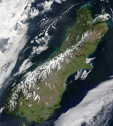
Snow highlights the Southern Alps in this satellite image
|
|
| Highest point | |
| Peak | Aoraki / Mount Cook |
| Elevation | 3,724 m (12,218 ft) |
| Dimensions | |
| Length | 500 km (310 mi) |
| Geography | |
| Location | South Island, New Zealand |
| Range coordinates | 43°30′S 170°30′E / 43.500°S 170.500°E |
The Southern Alps are a long mountain range in New Zealand's South Island. They are also known by their Māori name, Kā Tiritiri o te Moana. This huge range stretches almost the entire length of the island. Its highest parts are found on the western side. Many smaller mountain groups make up the Southern Alps.
The mountains have a special line called the Main Divide. This line separates the rivers and streams that flow to the east from those that flow to the west. The Main Divide also acts as a border between different areas, or regions. On the southeast side are Marlborough, Canterbury, and Otago. On the northwest side are Tasman and the West Coast.
Contents
Exploring the Southern Alps
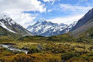
The Southern Alps stretch about 500 kilometers (310 miles) from northeast to southwest. The tallest peak is Aoraki / Mount Cook. It is the highest point in New Zealand, reaching 3,724 meters (12,218 feet) high.
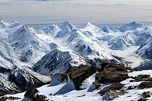
The Southern Alps have sixteen other peaks that are taller than 3,000 meters (9,800 feet). You can find many glaciers here, which are like slow-moving rivers of ice. In the late 1970s, there were over 3,000 glaciers larger than one hectare (2.5 acres). The longest one is the Tasman Glacier. It is about 23.5 kilometers (14.6 miles) long.
Many valleys in the mountains were carved out by glaciers. Some of these valleys now hold beautiful glacial lakes on the eastern side. Examples include Lake Coleridge in the north and Lake Wakatipu in Otago in the south.
Some small towns and places to visit in the Southern Alps include Maruia Springs, a spa near Lewis Pass, the town of Arthur's Pass, and Mount Cook Village.
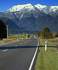
You can cross the Southern Alps using several main roads. These include Lewis Pass (State Highway 7), Arthur's Pass (State Highway 73), Haast Pass (State Highway 6), and the road to Milford Sound (State Highway 94).
History of the Name
The Southern Alps were named by Captain Cook on March 23, 1770. He described them as having a "prodigious height," meaning they were incredibly tall. Before Cook, Abel Tasman saw the mountains in 1642. He described the South Island's west coast as "a land uplifted high."
In 1998, the name of the range was officially changed. It became Southern Alps / Kā Tiritiri o te Moana. This change honored the Māori name for the mountains.
Mountain Weather and Climate
New Zealand has a humid, mild climate. The Southern Alps stand right in the path of the strong westerly winds. This causes the weather to change a lot across the range.
The amount of rain and snow varies greatly. On the West Coast, it can get about 3,000 millimeters (118 inches) of rain each year. Close to the Main Divide, it can get as much as 15,000 millimeters (590 inches)! But just 30 kilometers (19 miles) east of the Main Divide, it might only get 1,000 millimeters (39 inches). All this high rainfall helps the glaciers grow, especially above the Snow line.
The way the mountains are positioned creates great conditions for glider pilots. The town of Omarama, which is sheltered by the mountains, is famous around the world for its gliding.
The westerly winds also create a special weather pattern called the Nor'west arch. This happens when moist air is pushed up over the mountains. It forms an arch of cloud in an otherwise clear blue sky. You can often see this in summer over Canterbury and North Otago. The 'Nor'wester' is a type of wind called a foehn wind. It is similar to the Chinook wind in Canada. These winds happen when moist air hits mountains, rises, cools, and drops its rain. Then, the dry air flows down the other side, becoming warm and dry.
How the Mountains Formed (Geology)
The Southern Alps sit on a plate boundary. This is where two of Earth's giant plates, the Pacific Plate and the Indo-Australian Plate, meet. The Pacific Plate is pushing west, and the Indo-Australian Plate is moving north. This collision is part of the Pacific Ring of Fire.
Over the last 45 million years, this collision has pushed up rocks on the Pacific Plate. This created the Alps, which were once 20 kilometers (12 miles) thick! But much of this rock has worn away over time. The mountains have been rising fastest in the last 5 million years. They are still being pushed up today by the pressure of these plates. This pressure causes earthquakes along the Alpine Fault and other nearby faults.
Scientists discovered "extreme" hot water activity under Whataroa in 2017. This small town is located on the Alpine Fault. This hot water could be very useful for energy.
Plants of the Southern Alps
The mountains are full of different plants. About 25% of all of New Zealand's plant species grow above the treeline. This area is called the alpine plant habitat. At lower elevations, especially on the eastern side, you can find mountain beech forests. The cold, windy slopes above the treeline have areas of fellfield, which is rocky ground with low-growing plants. To the east, the Alps lead down to the Canterbury-Otago tussock grasslands.
Plants that are good at living in the cold alpine conditions include woody shrubs like Hebe, Dracophyllum, and Coprosma. You can also find the conifer snow totara (Podocarpus nivalis) and Carex sedge grasses.
Animals of the Southern Alps
The wildlife in the mountains includes the rock wren (Xenicus gilviventris). This small bird is found only in New Zealand. There are also many unique insects that live at these high altitudes. These include special flies, moths, beetles, and bees.
The beech forests at lower elevations are important homes for two birds: the great spotted kiwi (Apteryx haastii) and the South Island kaka (Nestor meridionalis meridionalis). The Kea is another interesting bird found here. It lives in the forested foothills and also in the higher, colder parts of the mountains. The Kea is the world's only alpine parrot. It was once hunted because people thought it was a pest.
Protecting the Mountains
The Southern Alps are mostly untouched and still have their natural plants and animals. A large part of the mountain range is protected in national parks. These include the Westland Tai Poutini National Park, Mount Aspiring National Park, and Aoraki / Mount Cook National Park. Other areas are also protected.
However, some introduced animals can harm the native plants. These include red deer (Cervus elaphus), chamois (Rupicapra rupicapra), and Himalayan tahr (Hemitragus jemlahicus). Sometimes, these animals are culled (reduced in number) to protect the environment. Native birds and reptiles are also in danger from introduced predators.
Panoramic view
See also
 In Spanish: Alpes del Sur para niños
 | Laphonza Butler |
 | Daisy Bates |
 | Elizabeth Piper Ensley |


