Hari Hari facts for kids
Quick facts for kids
Hari Hari
|
|
|---|---|

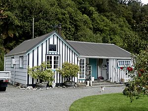
Hende's Ferry Cottage, a historic building by the bank of the Wanganui River in Hari Hari
|
|
| Country | New Zealand |
| Region | West Coast |
| District | Westland District |
| Ward | Southern |
| Electorates |
|
| Area | |
| • Total | 50.43 km2 (19.47 sq mi) |
| Population
(June 2023)
|
|
| • Total | 260 |
| • Density | 5.16/km2 (13.35/sq mi) |
| Time zone | UTC+12 (NZST) |
| • Summer (DST) | UTC+13 (NZDT) |
| Postcode |
7884
|
| Area code(s) | 03 |
| Local iwi | Ngāi Tahu |
Hari Hari (sometimes spelled Harihari) is a small town in the south-west of New Zealand's West Coast. It is located on the South Island, a little way from the Tasman Sea. Hari Hari sits between the Wanganui and Poerua Rivers.
The town is about 45 minutes south of the popular tourist spot, Hokitika. State Highway 6, a main road, goes through Hari Hari. It connects the town to Ross and the famous Franz Josef Glacier. Greymouth, the largest town in the Westland District, is about 110 kilometers (68 miles) away.
Contents
History and Activities
Hari Hari used to be a place where people cut down trees for wood, known as logging. You can still find old parts of a "bush tramway" in the area. A bush tramway was like a small railway used to carry logs out of the forest.
Today, the forests around Hari Hari are protected. This means people can enjoy nature without harming it. Popular things to do here include:
In 1908, a dairy factory opened in Hari Hari. It was called the Inter-Wanganui Co-op. This factory helped process milk from local farms. Today, the building is no longer used and is a ruin.
The Famous Flight Across the Tasman Sea
Hari Hari is most famous for an amazing event that happened on January 7, 1931. An Australian pilot named Guy Menzies made the first solo flight across the Tasman Sea. He flew all the way from Sydney, Australia!
Menzies had been flying for 11 hours and 45 minutes. He was trying to land in Blenheim, but strong winds pushed him off course. He thought a swamp near Hari Hari looked like a flat field for landing. He landed upside down, but luckily, he was not hurt!
On January 7, 2006, people in Hari Hari celebrated the 75th anniversary of this flight. About 400 people came to the celebration. To mark the special day, a famous Australian adventurer named Dick Smith flew the same route. But this time, Smith landed safely and upright in Hari Hari!
People of Hari Hari
Hari Hari is a small rural community. In 2018, about 240 people lived there. The population has changed a little over the years.
Most people in Hari Hari are of European descent, known as Pākehā. There are also people from Māori, Pasifika, and Asian backgrounds. Some people identify with more than one ethnicity.
When asked about their beliefs, many people in Hari Hari said they had no religion. Others were Christian or had other religions.
Education
Hari Hari has a school called South Westland Area School. It teaches students from year 1 (around age 5) all the way up to year 15 (around age 18). The school opened in 1969. Before that, there was a school called Hari Hari School, which started way back in 1865.
The South Westland Area School also has a special classroom located at Franz Josef Glacier School. This helps students in that area get an education closer to home.
There is also a special research center in Hari Hari called "The Green Elephant." It belongs to the University of Canterbury. Scientists and students use it to study the local environment.
Weather in Hari Hari
Hari Hari has a mild climate. The warmest months are January and February, with average high temperatures around 20-21 degrees Celsius (68-70 degrees Fahrenheit). The coldest months are July and August, with average high temperatures around 12-13 degrees Celsius (54-55 degrees Fahrenheit).
It rains quite a lot in Hari Hari throughout the year. December and January tend to be the wettest months. This rain helps keep the forests green and the rivers full.
| Climate data for Hari Hari (1971–2000) | |||||||||||||
|---|---|---|---|---|---|---|---|---|---|---|---|---|---|
| Month | Jan | Feb | Mar | Apr | May | Jun | Jul | Aug | Sep | Oct | Nov | Dec | Year |
| Mean daily maximum °C (°F) | 20.4 (68.7) |
21.2 (70.2) |
19.9 (67.8) |
17.5 (63.5) |
15.0 (59.0) |
12.7 (54.9) |
12.5 (54.5) |
13.3 (55.9) |
14.3 (57.7) |
15.7 (60.3) |
17.0 (62.6) |
19.2 (66.6) |
16.6 (61.8) |
| Daily mean °C (°F) | 15.6 (60.1) |
16.0 (60.8) |
14.6 (58.3) |
12.1 (53.8) |
9.2 (48.6) |
6.7 (44.1) |
6.4 (43.5) |
7.5 (45.5) |
9.3 (48.7) |
11.0 (51.8) |
12.4 (54.3) |
14.5 (58.1) |
11.3 (52.3) |
| Mean daily minimum °C (°F) | 10.7 (51.3) |
10.8 (51.4) |
9.2 (48.6) |
6.6 (43.9) |
3.3 (37.9) |
0.8 (33.4) |
0.2 (32.4) |
1.8 (35.2) |
4.3 (39.7) |
6.3 (43.3) |
7.8 (46.0) |
9.8 (49.6) |
6.0 (42.7) |
| Average rainfall mm (inches) | 480.8 (18.93) |
265.9 (10.47) |
443.2 (17.45) |
285.1 (11.22) |
257.8 (10.15) |
320.8 (12.63) |
370.7 (14.59) |
202.7 (7.98) |
294.2 (11.58) |
339.6 (13.37) |
364.5 (14.35) |
540.6 (21.28) |
4,165.9 (164) |
| Source: CliFlo (rain 1981–2010) | |||||||||||||
 | John T. Biggers |
 | Thomas Blackshear |
 | Mark Bradford |
 | Beverly Buchanan |


