Franz Josef / Waiau facts for kids
Quick facts for kids
Franz Josef / Waiau
|
|
|---|---|
|
Village
|
|

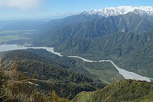
Franz Josef (middle left), next to the Waiho River, as seen from Alex Knob
|
|
| Country | New Zealand |
| Region | West Coast |
| District | Westland District |
| Ward | Southern |
| Electorates |
|
| Area | |
| • Total | 5.31 km2 (2.05 sq mi) |
| Population
(June 2023)
|
|
| • Total | 530 |
| • Density | 99.8/km2 (258.5/sq mi) |
| Time zone | UTC+12 (NZST) |
| • Summer (DST) | UTC+13 (NZDT) |
| Postcode |
7886
|
| Area code(s) | 03 |
| Local iwi | Ngāi Tahu |
Franz Josef (officially Franz Josef / Waiau) is a small town on the West Coast of New Zealand's South Island. It's famous for being close to the amazing Franz Josef Glacier. The town is located near the Waiho River, which flows from the glacier all the way to the Tasman Sea. Nearby towns include Whataroa (about 32 kilometers north-east) and Fox Glacier (about 23 kilometers south-west).

Contents
History of the Name
The local Māori people called this area Waiau. This name means "swirling waters," which describes the river here.
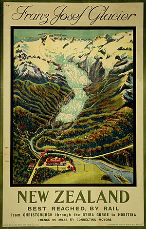
In the 1860s, a explorer named Sir Julius von Haast named the nearby Franz Josef Glacier. He chose the name to honor Franz Joseph I of Austria, who was the Emperor of Austria at that time. Later, the town itself was named after this famous glacier.
Because of the Ngāi Tahu Claims Settlement Act 1998, the town's official name was changed to Franz Josef / Waiau. This change recognizes both its European and Māori history.
Geography and River Flooding
The Waiho River flows through Franz Josef. Over the years, the riverbed has risen a lot. This means the river is getting higher. Heavy rain and melting ice from the glacier can make the river flow very fast.
Protecting the Town from Floods
Experts predict the riverbed could rise by 2 meters every 10 years. This means in about 30 years, the river could be higher than the town itself!
There have been big floods in the past. In February 2016, a flood caused about $30 million in damage. In March 2019, a huge storm brought 400 millimeters of rain. The bridge over the Waiho River was destroyed, cutting off the town. The town also flooded, and many people had to leave their homes. It took 18 days and $6 million to rebuild the bridge.
To protect Franz Josef, the government approved a $24 million plan in 2020. This plan included building strong rock walls along the riverbanks. It also involved raising the highway bridge to make it safer from floods.
Ideas for the Future
Because of the flood risk, people are thinking about long-term solutions. One idea is to let the river widen its path. This would mean flooding some farmland, affecting many people and properties. If this happens, the government would need to pay compensation to those affected.
Another big idea is to move the entire town of Franz Josef! The proposed new location is near Lake Mapourika, about 10 kilometers north. This move would be very expensive, possibly costing up to $1 billion. This plan would also help the town avoid problems from the nearby alpine fault line.
Population and Visitors
Franz Josef is a small rural town. It covers about 5.31 square kilometers. In 2018, about 483 people lived here.
| Historical population for Franz Josef | ||
|---|---|---|
| Year | Pop. | ±% p.a. |
| 2006 | 303 | — |
| 2013 | 330 | +1.23% |
| 2018 | 483 | +7.92% |
The town's population has grown quite a bit. In 2018, there were 153 more people than in 2013. Many people who live here are between 15 and 64 years old.
Even though few people live in Franz Josef, it used to get around 600,000 tourists every year! This was before the COVID-19 pandemic made travel difficult.
Tourism and Attractions
The main reason people visit Franz Josef is the amazing Franz Josef Glacier. The glacier's end is only about 5 kilometers from the town, making it easy to visit. The town is located inside the beautiful Westland Tai Poutini National Park.
Franz Josef has many places for visitors to stay. You can find hotels, motels, holiday homes, camping sites, and backpacker hostels. During the busy season, up to 2,000 people might stay overnight. The town also has a petrol station, a busy heliport for helicopter tours, and many restaurants and shops.
You can reach the Franz Josef Glacier valley by walking tracks or a small road. This road starts just south of the village on the main highway.
West Coast Wildlife Centre
Franz Josef is also home to the West Coast Wildlife Centre. This special place works with the Department of Conservation and local Māori groups. Their main goal is to help hatch and raise two of the world's rarest kiwi species: the rowi and the Haast tokoeka.
The centre is open every day. You can get a general pass to visit for 24 hours. They also offer VIP guided tours where you can go behind the scenes. These tours show you how they hatch and care for the kiwi chicks.
Churches in Franz Josef
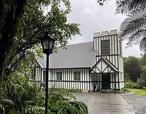
St James Church
St James Church is a small Anglican church. It sits in a natural bush area and looks out over the Waiho River. The church opened in 1931. It is special because it has clear glass windows behind the altar. These windows offer amazing views of the river, mountains, and forest. Sometimes, you can even see the Franz Josef Glacier through the altar window! In 1990, Heritage New Zealand recognized St James Church as a very important historic place.
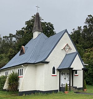
Our Lady of the Alps
Our Lady of the Alps is a small Catholic church. It is located right next to State Highway 6 on the edge of Franz Josef. The church was officially opened in December 1951. Its design looks like Swiss mountain churches, with a steep roof to help snow slide off. It also has strong buttresses (supports). Inside the porch, there are two stained-glass windows. One shows climbing gear, and the other shows skis with a shield, a brandy flask, and bread.
A church service (called Mass) is held weekly at Our Lady of the Alps.
Transport and Services
State Highway 6, a major road, runs right through the town.
Franz Josef has its own electricity network. Power comes from the national grid in Hokitika, traveling 146 kilometers. There's also a local hydroelectric power station, Wahapo, about 20 kilometers north. This station can provide power to the town if the main supply is lost.
The local council manages the water and wastewater systems in Franz Josef.
Education
Franz Josef Glacier School is a school for students from Year 1 to Year 8 (ages 5-13). As of 2023, it has about 34 students. The closest high school is South Westland Area School, which is 62 kilometers away in Hari Hari.
The number of students at the school changes a lot. It depends on how many families move to or from Franz Josef for tourism jobs. For example, the school had 45 students in 2002, but only 12 in 2012. It went up to 51 in 2018, then dropped to 34 in 2022 when tourism slowed down due to the COVID-19 pandemic. When student numbers drop below 25, the school sometimes has only one teacher.
Climate
| Climate data for Franz Josef (1991–2020) | |||||||||||||
|---|---|---|---|---|---|---|---|---|---|---|---|---|---|
| Month | Jan | Feb | Mar | Apr | May | Jun | Jul | Aug | Sep | Oct | Nov | Dec | Year |
| Mean daily maximum °C (°F) | 20.0 (68.0) |
20.5 (68.9) |
18.9 (66.0) |
16.7 (62.1) |
14.5 (58.1) |
12.2 (54.0) |
11.9 (53.4) |
12.6 (54.7) |
13.7 (56.7) |
14.9 (58.8) |
15.9 (60.6) |
18.4 (65.1) |
15.9 (60.5) |
| Daily mean °C (°F) | 15.2 (59.4) |
15.4 (59.7) |
14.1 (57.4) |
12.2 (54.0) |
10.2 (50.4) |
8.2 (46.8) |
7.6 (45.7) |
8.2 (46.8) |
9.3 (48.7) |
10.5 (50.9) |
11.7 (53.1) |
13.9 (57.0) |
11.4 (52.5) |
| Mean daily minimum °C (°F) | 10.5 (50.9) |
10.4 (50.7) |
9.3 (48.7) |
7.8 (46.0) |
6.0 (42.8) |
4.1 (39.4) |
3.3 (37.9) |
3.7 (38.7) |
4.9 (40.8) |
6.2 (43.2) |
7.5 (45.5) |
9.4 (48.9) |
6.9 (44.5) |
| Average rainfall mm (inches) | 552.0 (21.73) |
357.6 (14.08) |
396.5 (15.61) |
389.4 (15.33) |
471.0 (18.54) |
455.7 (17.94) |
317.8 (12.51) |
426.6 (16.80) |
520.1 (20.48) |
594.1 (23.39) |
480.7 (18.93) |
593.7 (23.37) |
5,555.2 (218.71) |
| Mean monthly sunshine hours | 117.9 | 106.8 | 116.3 | 101.9 | 91.6 | 76.0 | 93.8 | 104.1 | 91.1 | 89.4 | 96.4 | 83.3 | 1,168.6 |
| Source: CliFlo | |||||||||||||
 | Emma Amos |
 | Edward Mitchell Bannister |
 | Larry D. Alexander |
 | Ernie Barnes |


