Waiho River facts for kids
Quick facts for kids Waiho River |
|
|---|---|

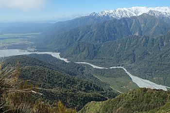
Waiho River flowing out of the Franz Josef Glacier valley
|
|
| Country | New Zealand |
| Physical characteristics | |
| Main source | Franz Josef Glacier |
| River mouth | Tasman Sea |
| Length | 25 km (16 mi) |
The Waiho River is a river located on the West Coast of New Zealand's South Island. It gets its water from the melting ice of the famous Franz Josef Glacier. The river flows right past the main town of Franz Josef.
About the Waiho River
The Waiho River is also sometimes called the Waiau River. It is about 25 kilometers (15.5 miles) long. The river's water level can change a lot. This is because it depends on how much rain falls and how much snow melts from the glacier.
Where the River Flows
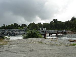
The Waiho River flows out of the Franz Josef Glacier valley. It then goes past the town of Franz Josef. State Highway 6, an important road, used to cross the river on a long, single-lane bridge.
The Waiho River eventually joins with a stream called Docherty Creek. After that, it flows into the Tasman Sea. This meeting point is about 10 kilometers (6.2 miles) southwest of a place called Okarito.
The Story of the Waiho Bridge
On March 26, 2019, a very big rainstorm hit the area. Over 400 millimeters (about 16 inches) of rain fell! This huge amount of rain caused the Waiho River to swell up. The powerful water flow sadly destroyed the bridge that carried State Highway 6.
Because the bridge was gone, the road link was broken. This meant people could not easily travel through the area. But workers quickly got to work! They rebuilt the bridge and one of its supports. The road was reopened after just 18 days. This quick repair helped everyone get back to normal travel.
 | Claudette Colvin |
 | Myrlie Evers-Williams |
 | Alberta Odell Jones |


