
Franz Josef Glacier facts for kids
Quick facts for kids Franz Josef Glacier /Kā Roimata o Hine Hukatere |
|
|---|---|

Franz Josef Glacier from the valley floor in 2001
|
|

Franz Josef Glacier / Kā Roimata o Hine Hukatere
Location in West Coast
|
|
| Coordinates | 43°28′01″S 170°11′30″E / 43.46694°S 170.19167°E |
| Length | 10.5 km (6.5 mi) |
| Thickness | Up to 300 metres (980 ft) thick |
| Status | Retreating |
The Franz Josef Glacier / Kā Roimata o Hine Hukatere is a long, icy river located in Westland Tai Poutini National Park on the West Coast of New Zealand's South Island. It stretches about 12 km (7.5 mi) and is known as a temperate maritime glacier. This means it's found in a warmer climate near the sea.
Along with the Fox Glacier, which is about 20 km (12 mi) south, and another glacier, it flows down from the Southern Alps. These glaciers reach very low altitudes, less than 300 metres (980 ft) above sea level. The area around these two glaciers is part of Te Wahipounamu, a special World Heritage Site. The river that flows from the end of the Franz Josef Glacier is called the Waiho River.

Contents
The Glacier's Names and Their Stories
Māori Name: Kā Roimata o Hine Hukatere
The traditional Māori name for the glacier is Kā Roimata o Hine Hukatere. This means 'The tears of Hine Hukatere'. It comes from an old story. Hine Hukatere loved climbing mountains and convinced her boyfriend, Tuawe, to climb with her. Tuawe wasn't as good at climbing as Hine Hukatere. One day, an avalanche swept him away, and he died. Hine Hukatere was so sad that her many tears flowed down the mountain. Rangi, the Sky Father, felt sorry for her and froze her tears to form the glacier.
European Naming
The first European to describe one of the West Coast glaciers (thought to be Franz Josef) wrote about it in a ship's log in 1859. Later, in 1865, a German geologist named Julius von Haast gave the glacier its European name. He named it after Emperor Franz Joseph I of Austria.
After a special law was passed in 1998, the glacier's name was officially changed to include both names: Franz Josef Glacier / Kā Roimata o Hine Hukatere.
Where the Glacier Is Located
Snowfield and Valley
The top part of the Franz Josef Glacier, called the névé or snowfield, is over 2,500 metres (8,200 ft) above sea level. It covers an area of 20 square kilometres (7.7 sq mi). This large snowfield is more than 300 metres (980 ft) deep. It feeds huge amounts of packed snow into a steep and narrow valley. The glacier drops quickly to very low altitudes, reaching 300 metres (980 ft) above sea level in just 11 km (6.8 mi).
This unique combination of features allows Franz Josef Glacier to exist where most glaciers in warmer areas would have melted. It even shares its valley with a temperate rainforest!
Glacier's Past and Present Reach
Franz Josef Glacier currently ends about 19 km (12 mi) from the Tasman Sea. Around 18,000 years ago, near the end of the last ice age, it stretched all the way to the coastline or even further. As the glacier melted and moved back, it left behind piles of rock and ice called moraines. These created coastal hills and lakes. For example, Lake Wombat is a kettle lake formed by ice left in a moraine 9,000 years ago. Peters Pool, closer to the glacier, formed in the same way only 210 years ago.
The Waiho Loop, about 4 km north of the Franz Josef village, is a large pile of rubble left by the glacier between 3,000 and 12,000 years ago. This arc of rock is 80 m high and was too rough for farming, so it's still covered in native forest.
How the Glacier Changes: Advance and Retreat

Franz Josef Glacier often grows (advances) and shrinks (retreats). This happens because of the balance between how much snow falls at its top and how much ice melts at its bottom. Over the last 14,000 years, most glaciers around the world have gotten smaller. Many of New Zealand's large glaciers also shrank a lot in the late 1900s due to global warming.
However, in the Southern Alps, warmer temperatures can cause more rain and snow to fall on the western side. Because Franz Josef Glacier is short and steep, it reacts quickly to more snow at its top. If the extra precipitation is snow, the glacier will grow. If it's rain, it will shrink. It takes about 5–6 years for more snowfall to make the glacier's end point change.
Historical Changes
Franz Josef Glacier grew quickly during the Little Ice Age, reaching its biggest size in the early 1700s. When Julius von Haast first saw it, the glacier was much longer and 300 m higher than it is today. Between its first official map in 1893 and 1983, Franz Josef Glacier had shrunk by 3 km up the valley.
The glacier also had several periods of growth in the 1900s:
- 1946 to 1951 (grew 340 m)
- 1965 to 1967 (grew 400 m)
- 1983 to 1999 (grew 1420 m)
- 2004 to 2008 (grew 280 m)
Each time it grew, it was followed by an even bigger period of shrinking.

This changing behavior is shown on a postage stamp from 1946. It shows the view from St James Anglican Church. The church was built in 1931 with a large window to see the glacier. By 1954, the glacier could no longer be seen from the church. But it briefly reappeared in 1997.
Between 1983 and 2008, while most glaciers worldwide were shrinking, many New Zealand glaciers actually grew. Franz Josef regained almost half the ice it had lost in the previous century. This unusual growth was likely due to a series of cooler years caused by more southerly winds in the Tasman Sea. After 2008, the glacier began to shrink very quickly. It lost 1.5 km of its length between 2008 and 2017. Now, it is 3 km shorter than it was 100 years ago. Scientists predict that Franz Josef Glacier could shrink by 5 kilometres (3.1 mi) and lose 38% of its ice by 2100 if warming continues at a moderate rate. It might even shrink by as much as 8 kilometres (5.0 mi).
Glacier Floods
Sometimes, there are sudden floods from the glacier called jökulhlaups. These happen when water builds up in ice tunnels and then bursts out. The snowfields of Fox and Franz Josef glaciers get some of the highest amounts of rain and snow in the world, up to 15 m a year!
In December 1965, after 280 mm of rain in two days, the Waiho River burst out of the glacier. It carried large chunks of ice downstream. These ice chunks were still up to 50 cm across when they reached the Tasman Sea, 20 km away. Another flood destroyed the access road bridge in 1989. Then, another flood happened in April 1991. In March 2019, heavy rain destroyed the bridge across the Waiho River again. It took 18 days to replace it.
Plants and Nature Around the Glacier
Westland Tai Poutini National Park is one of the few places in New Zealand with a complete natural landscape, from mountain peaks to the sea. As Franz Josef Glacier has retreated, native forests have grown on the bare rock it left behind. You can tell how long ago the glacier retreated by looking at the different stages of plant growth, called ecological succession. Some bare rock was only exposed ten years ago, while other areas were exposed in 1951, 1830, 1750, and 1600.
Visiting the Glacier
The Fox and Franz Josef glaciers are among the easiest glaciers in the world for people to visit. For over a century, they have been a very popular tourist attraction.
.jpg)
The glacier is connected to the Graham family, especially mountaineers and guides Alec and Peter Graham, hotelier Rose Graham, and historian Dorothy Fletcher (who was born Graham). Their hotel services led to the building of St James Church.
Today, the Franz Josef glacier area is the third-most-visited tourist spot in New Zealand. It's one of the main attractions on the West Coast. In 2008, about 250,000 people visited each year. By 2017, this number grew to 700,000 visitors a year.
Changes to Access
It used to be possible to walk right up to the glacier. However, in March 2012, the front part of the glacier collapsed, making it too dangerous to approach closely. Signs now warn people not to go past the safety barriers at the lookout. As of 2020, the valley walk ends at a lookout about 50 m from the main face of the glacier.
To visit the glacier up close now, you usually need a helicopter flight to get past the unstable front area. Glacier walks also require special gear like ice axes and crampons (spikes that attach to sturdy boots). Tour companies usually provide these.

Since walking tours to the glacier take a long time and only go to the first icefall (a frozen waterfall), many tourists choose helicopter tours. These tours usually drop guests between the first and second icefalls for a guided 1–2 hour walk on the glacier. The glacier's landscape changes almost daily because it flows unusually fast. Some walks even go through ice tunnels. These tours are generally considered safe, though they can be a bit tiring.
Other Ways to See the Glacier
Another way to see the glacier is to hike up the 1,303 metres (4,275 ft) high Alex Knob. This 8-hour day hike offers great views of the Franz Josef Glacier and the valley below. The path up Alex Knob is a good hiking trail, but it's tough because it climbs steeply about 1,100 metres (3,600 ft) in height. It's considered an "advanced" hike due to its length.
At the entrance of the valley is the village of Franz Josef. About 330 people live there permanently. It's 5 km from the glacier on State Highway 6. The village has a petrol station, a busy heliport, many places to stay (up to 2,000 people can stay overnight during busy times), restaurants, and shops. Just south of the village, a paved road leads from the highway into the Franz Josef Glacier valley and to a car park. Several short walks start from this road and the car park. You can also comfortably cycle from Franz Josef village to the car park.

Images for kids
-
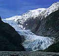
The glacier from the valley floor in 2001
-
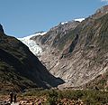
The same viewpoint in 2016
_%E2%80%93_the_glacier_in_2016.jpg)
See also
 In Spanish: Glaciar Franz Josef para niños
