
Fox Glacier facts for kids
Quick facts for kids Fox Glacier |
|
|---|---|
| Fox Glacier / Te Moeka o Tuawe | |
 |
|

Fox Glacier
Location in New Zealand
|
|
| Coordinates | 43°30′07″S 170°04′52″E / 43.502°S 170.081°E |
| Length | 13 km (8.1 mi) |
| Status | Retreating |
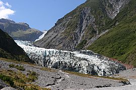
The Fox Glacier (also known as Māori: Te Moeka o Tuawe) is a huge, slow-moving river of ice. It is about 13-kilometre-long (8.1 mi). You can find it in the Westland Tai Poutini National Park on the West Coast of New Zealand's South Island.
Like the nearby Franz Josef Glacier, Fox Glacier is one of the easiest glaciers in the world to visit. Its end, called the terminal face, is only about 300 metres (980 ft) above sea level. This is very close to the village of Fox Glacier. Many people visit it, especially during the busy tourist season. About 1000 people come to see it every day!
How the Fox Glacier Got Its Name
The local Māori call the glacier Te Moeka o Tuawe. This means 'The bed of Tuawe'.
There is an old Māori story about how it got this name:
- A girl named Hine Hukatere loved climbing mountains.
- She convinced her boyfriend, Tuawe, to climb with her.
- Tuawe wasn't as good at climbing as Hine Hukatere.
- Sadly, an avalanche swept Tuawe away, and he died.
- Hine Hukatere was very sad and cried many tears.
- Rangi, the Sky Father, felt sorry for her.
- He froze her tears to form the Franz Josef Glacier.
- The Fox Glacier marks the place where Tuawe rests.
In 1857, Māori people showed the glaciers to the first Europeans, Leonard Harper and Edwin Fox.
Later, in 1865, a German geologist named Julius von Haast explored the area. He named two glaciers Victoria and Albert. He named them after Queen Victoria and her husband, Prince Albert.
The Victoria Glacier kept its name. But the lower part of the Albert Glacier was renamed in 1872. This happened after Sir William Fox, who was New Zealand's Premier at the time, visited.
An explorer named Charlie Douglas had already seen the glacier in the 1860s. He was looking for a lost cow! He later wrote that he "did not pay much attention to the glaciers" back then.
In 1998, the glacier's name officially changed again. It became Fox Glacier / Te Moeka o Tuawe. This was part of the Ngāi Tahu Claims Settlement Act 1998.
Where the Glacier Is
.JPG)
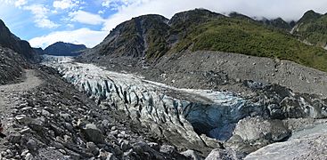
The Fox Glacier starts high up in the Southern Alps. It is fed by four other glaciers. It flows down 2,600 m (8,500 ft) over its 13 kilometres (8.1 mi) journey. It ends near a rainforest, about 300 metres (980 ft) above sea level.
For most of the last 100 years, the glacier was getting smaller. This is called "retreating." But between 1985 and 2009, it actually grew bigger, or "advanced." In 2006, it was growing by about a metre each week!
By January 2009, the end of the glacier was still moving forward. Its steep ice faces would often collapse. Since then, it has been getting much smaller again. You can see where the glacier reached its highest point around 2009. It looks like a line of plants on the southern slope.
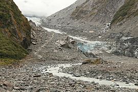
The water that melts from the glacier forms the Fox River. During the last ice age, the glacier was even bigger. It reached beyond today's coastline. As it melted and retreated, it left behind many piles of rock and dirt called moraines. Lake Matheson formed in a hollow left by the glacier.
-
The glacier in 2007
-
The glacier in 2013
-
The glacier in 2013, showing how high it reached around 2009
-
The Fox River flowing out from the glacier


Visiting the Fox Glacier
.jpg)
In the 1890s, Charlie Douglas wrote about the interesting places around Fox Glacier. He thought it would be easy to travel from Cook's Flat to the glacier. He also said the road between Fox Glacier (then called Weheka) and Franz Josef was very bad. He even said he left the road and walked through the bush because it was better! By 1903, the road had improved.
Charlie Douglas had helped survey the glacier and built the first hut there. It was called the iron hut.
In the 1920s, the West Coast area became popular for its beautiful mountains, lakes, and forests. Visitors to Weheka stayed in local homes. Then, in 1928, the Sullivan brothers opened the first hotel, the Fox Glacier Hostel. This hotel is still open today!
.jpg)
Official glacier tours started around this time. Famous mountain climbers like Frank Alack and Harry Ayres worked as guides. People could reach the ice by walking along the north side of the Fox River valley and crossing a swingbridge. They would get onto the ice at a shelter built in 1931. As the glacier moved back, new ways were found to reach it. Eventually, the northern route became the main road for tourists.

The Chancellor Hut was built in 1930–31. It is high up on Chancellor Ridge, about 200 metres (660 ft) above the glacier. All the building materials had to be carried up the glacier by hand! This was before helicopters could fly things in. It is the oldest mountain hut in the Southern Alps still in its original spot. It is considered a historic building. The hut was built so tourists could enjoy climbing, not just for serious mountaineers.
In the 1930s and 1940s, roads were built on both sides of the valley to make it easier to get to the glacier. The northern road led to the main car park for people who wanted to walk to the glacier. There were signs and barriers to keep people out of dangerous areas near the glacier's active face.
However, some visitors did not follow the safety warnings. It is very important to always stay behind safety barriers and follow all warnings when visiting glaciers.
On March 26, 2019, heavy rains caused big floods. They also caused a huge landslide in the Fox River valley. This landslide washed away about 150 metres (490 ft) of the northern glacier access road and destroyed the car park. The road had been damaged many times before.
Because of the landslide, the road has been closed for a long time. There is no easy way to fix it. Now, the only way to reach the glacier is by helicopter.
To help the local area, money was given for other tourism projects. These include:
- Making a cycleway longer to Lake Matheson.
- Improving and reopening the track to Lake Gault.
- Making the road and track access better on the south side of the Fox River valley.
- Reopening the coastal walkway to Galway Beach.
-
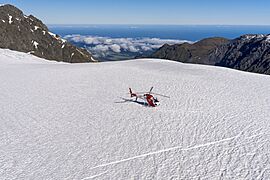
The upper part of Fox Glacier
-
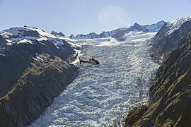
The upper slope of Fox Glacier
-
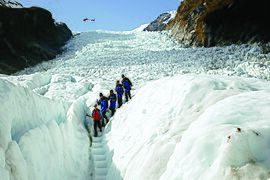
A group on a heli-hiking tour
-
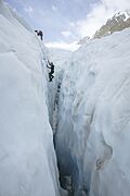
Learning to ice climb
-
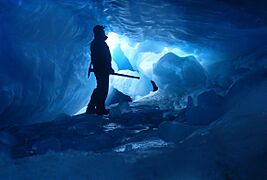
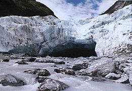
An ice cave


See also
 In Spanish: Glaciar Fox para niños
