
Lake Matheson facts for kids
Quick facts for kids Lake Matheson |
|
|---|---|
_%26_Mount_Tasman_-_Lake_Matheson_(New_Zealand).jpg) |
|

Lake Matheson
Location in New Zealand
|
|
| Location | Fox Glacier, West Coast, South Island |
| Coordinates | 43°26′17″S 169°57′47″E / 43.43806°S 169.96306°E |
| Type | monomictic dystrophic |
| Native name | Te Ara Kairaumati Error {{native name checker}}: parameter value is malformed (help) |
| Etymology | local farmer Murdoch Matheson |
| Surface area | 30 ha (74 acres) |
| Average depth | 12 m (39 ft) |
| Shore length1 | 1.5 km (0.93 mi) |
| Surface elevation | 100 m (330 ft) |
| 1 Shore length is not a well-defined measure. | |
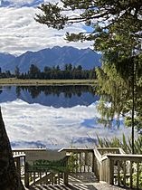
Lake Matheson (also known as Māori: Te Ara Kairaumati) is a small lake in New Zealand. It is located near the town of Fox Glacier on the South Island. This lake is famous for its amazing reflections of New Zealand's tallest mountains, Aoraki / Mount Cook and Mount Tasman.
For the local Māori, Lake Matheson was a traditional place to gather food. Today, there is an easy walking track around the lake. Many visitors come to see the stunning mountain reflections on its calm surface.
Contents
Lake Matheson's Geography

Lake Matheson was formed about 14,000 years ago. This happened at the end of the last ice age. The Fox Glacier / Te Moeka o Tuawe was melting and moving back. It left behind two large piles of rock and dirt called moraines. A huge block of ice was also left, covered by gravel. As this ice slowly melted, it created the lake bed.
Today, the lake is about 12 kilometers from the end of the glacier. The moraines and other gravels blocked the valley. This allowed the lake to grow. Small streams and water seeping from the ground feed the lake. There isn't a big river flowing in or out of it.
Lake Matheson covers an area of 30 hectares. Its shoreline is about 1.5 kilometers long. The lake is about 12 meters deep on average. The streams that flow into the lake pass through thick native forests. These streams carry natural materials and tannins from the trees. This makes the water a dark brown color. This dark color is what helps the lake act like a giant mirror. It makes the reflections of the mountains look even clearer!
The lake water is also a bit acidic. It doesn't have many nutrients. Sometimes, it has very little oxygen. These are all signs of a "dystrophic" lake. This means it's slowly filling up with organic matter. Over a very long time, the lake will eventually become a peat bog.
Lake Matheson's History
The Māori people traditionally called the lake Te Ara Kairaumati. It was a special "mahinga kai," which means a place for gathering food. Māori travelers would stop here to catch longfin eels or water birds. They were often on their way to the coast to collect pounamu (greenstone).
Later, the first European settlers, called Pākehā settlers, arrived in the area. They named the lake Lake Matheson. This was after Murdoch Matheson, a farmer who lived nearby in the 1870s.
.jpg)
Since the early 1900s, tourism has grown in New Zealand. Lake Matheson became a very popular spot. People loved its reflections of the Southern Alps mountains. You can see peaks like Mount Haast, La Perouse, and New Zealand's highest mountains, Aoraki / Mount Cook and Mount Tasman.
The best time to see these reflections is at dawn or dusk. It's even better on a calm, clear morning. This is before the wind can disturb the water. It's also before clouds might cover the mountain peaks.
In the 1950s, the nearby Fox Glacier Hotel offered trips to the lake. Visitors would take a bus to the start of the path. Then, they would walk for about 15 minutes through the forest. There were no bridges or proper tracks back then. They would then get into a rowboat. The boat would take them to Reflection Island. There, they would wait for the water to become still. Then, the famous reflections would appear!
The amazing view across Lake Matheson became very famous. It was printed on chocolate boxes, beer bottles, calendars, and souvenirs. Today, Lake Matheson is one of the most photographed lakes in all of New Zealand.
Walking Around Lake Matheson
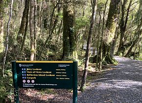
The Department of Conservation (DOC) looks after the area around Lake Matheson. It is part of Westland Tai Poutini National Park. DOC maintains the walking tracks and viewing spots.
There is an easy 2.6-kilometer walking track that goes all the way around the lake. It starts and ends at the Matheson Cafe. This cafe is about 5 kilometers from Fox Glacier town. The track crosses a cool suspension bridge over the Clearwater River. It leads to several great viewing points. The "View of Views" and Reflection Island are at the far end of the lake. The whole walk takes about 1½ hours.
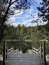
The first 20 minutes of the walk is easy for wheelchairs. This part leads to a pontoon jetty that goes out into the lake.
-
-
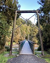
Swingbridge
-
Reflection Island
-
View of Views
-
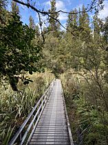
Boardwalk through wetland


In 2019, a big landslide blocked the road to the Fox Glacier. To help visitors, the government improved the facilities at Lake Matheson. They built a cycling and walking trail from the town to the lake. An old track to Lake Gault, which is an 8-kilometer round trip, was also improved. Now it's an easy walk too.
Plants and Animals at Lake Matheson
The lake and its surrounding area are mostly covered by native podocarp forest. Around the lake's edge, you'll find trees like Hall's tōtara (Podocarpus laetus), southern rātā (Metrosideros umbellata), kāmahi (Weinmannia racemosa), and rimu (Dacrydium cupressinum). Other trees include miro (Prumnopitys ferruginea), broadleaf (Griselinia littoralis), kahikatea (Dacrycarpus dacrydioides), mountain horopito (Pseudowintera colorata), and pate (Schefflera digitata). As the walkway goes higher, rimu and Quintinia serrata become more common.
A rare water plant called stout water milfoil (Myriophyllum robustum) lives in the lake. The wetlands near the lake have flax (Phormium tenax) and spike sedge (Eleocharis acuta).
-
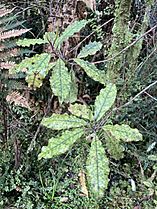
Quintinia serrata


Many ferns and mosses grow around the lake. You might see the Prince of Wales feathers fern (Leptopteris superba), shining spleenwort (Asplenium oblongifolium), and hanging spleenwort (Asplenium flaccidum). The giant moss Dawsonia can also be spotted.
-
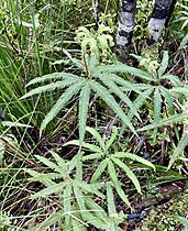
Umbrella fern
-
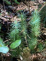
Dawsonia


Fernbirds, or mātātā (Poodytes punctatus), live in the wetlands. The rare Ōkārito brown kiwi, called rowi (Apteryx rowi), has been released in the nearby Omoeroa Ranges since 2018. A local eco-tourism group started "Project Early Bird" in 2018. They set up 80 traps around Lake Matheson. These traps help catch animals like stoats and rats that are not native to New Zealand. This helps protect the native wildlife.
Images for kids
-
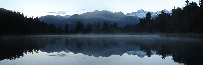
Before sunrise
-
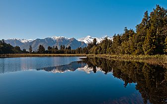
Just after sunrise
-
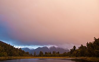
Just before sunset
-
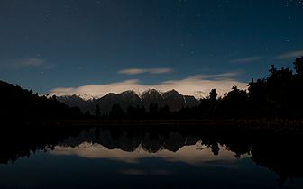
At night
-
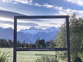
Photo opportunity at the start of the walk
-
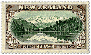
1946 "Peace and Tranquility" stamp

_just_after_the_sunrise.jpg)
_just_before_the_sunset.jpg)
_at_night.jpg)


See also
 In Spanish: Lago Matheson para niños
