
Ross, New Zealand facts for kids
Quick facts for kids
Ross
|
|
|---|---|

An aerial photograph of Ross, with the Tasman Sea seen to the right
|
|
| Country | New Zealand |
| Region | West Coast |
| District | Westland District |
| Ward | Northern |
| Electorates |
|
| Area | |
| • Total | 8.87 km2 (3.42 sq mi) |
| Population
(June 2023)
|
|
| • Total | 280 |
| • Density | 31.6/km2 (81.8/sq mi) |
| Time zone | UTC+12 (NZST) |
| • Summer (DST) | UTC+13 (NZDT) |
| Postcode |
7812
|
| Area code(s) | 03 |
| Local iwi | Ngāi Tahu |
Ross is a small town on the West Coast of New Zealand's South Island. It's about 27 kilometers (17 miles) south-west of Hokitika. Ross is known for its history, especially during the exciting gold rush days. It is located in the Westland District.
Contents
History of Ross
Ross was founded in the 1860s during the West Coast gold rush. It quickly became a very important place for gold miners. At its busiest, about 2,500 people lived in the town.
Gold Mining in Ross
After the gold in the area started to run out in the early 1870s, the population of Ross became smaller. Miners sometimes found quartz on a nearby ridge called Mount Greenland. Not much gold was found for a while. Then, in 1909, two miners made an amazing discovery. They found a huge gold nugget that weighed 3.1 kilograms (about 6.8 pounds)! This special nugget was named the "Honourable Roddy Nugget." It was named after Roderick McKenzie, who was the Minister for Mines at that time.
Chinese Miners in Ross
From 1872 to the early 1900s, many Chinese miners lived and worked in Ross. Today, there is a special Chinese Miners' Memorial Garden by Ross Lake. This garden remembers their important contributions to the town's history.
How Ross Got Its Name
The settlement had a few different names at first. It was called Jones Flat, and sometimes Georgetown or Totara. Around 1866, it was named Rosstown, which was later shortened to Ross. The town was named after George Ross. He was the treasurer for the Canterbury Provincial Council when the town was named.
People of Ross
Ross is a small rural town. As of 2018, about 285 people live there. The population has changed a little over the years. In 2006, there were 291 people, and in 2013, there were 294.
Who Lives in Ross?
In 2018, there were more males (156) than females (129) in Ross. About 42 people were under 15 years old. Most people in Ross are of European background (90.5%). Some people also identify as Māori (13.7%), Asian (2.1%), or other ethnicities. Many people in Ross (58.9%) said they had no religion. About 32.6% were Christian.
Economy of Ross
The main ways people earn a living in Ross are through farming and forestry. For many years, a large open-cut mine operated right next to the town. This mine started in 1988. In the 2000s, the big pit created by the mine was filled with water. This is how Ross Lake was formed.
Places to See and Things to Do
Ross has some useful places and interesting attractions.
Local Amenities
You can find a small shop in Ross that sells everyday items and has a New Zealand Post office. There's also a small self-service petrol station. The town has a volunteer fire brigade and a police station to help keep everyone safe.
Chinese Miners' Memorial Garden
Next to Ross Lake, you'll find the beautiful Chinese Miners' Memorial Garden. A group of volunteers worked for two years to create this garden. It cost a lot of money to build, but it's a special place. The garden has a Chinese pavilion, which is a type of open building, and many pretty trees and plants.
Sometimes, the lake levels can rise, which has caused problems for the garden. In 2020, a slip blocked the lake's outlet, and the pavilion was flooded. Volunteers worked hard to dig a small channel to help the water flow away. Local councils and the community worked together to find a solution. In 2021, they agreed to lower the lake levels to protect the garden from future flooding.
Education in Ross
Ross has one school called Ross School. It's a primary school for students in years 1 to 6. As of 2023, about 40 students attend the school. Ross School first opened its doors in 1875. In 2000, it celebrated its 125th anniversary!
For older students (years 7 to 13), the closest school is Westland High School. This school is located in Hokitika.
Getting Around Ross
Roads and Buses
State Highway 6 goes right through Ross. This road connects the town to Hokitika in the north. It also connects to Hari Hari and Franz Josef in the south. You can also catch a bus service in Ross. Intercity Coaches provides daily bus services to places like Fox Glacier and Greymouth.
Cycle Trail
Ross is the southern end of the West Coast Wilderness Trail. This is a popular cycle route that stretches all the way north to Greymouth. It's a great way to explore the beautiful West Coast scenery by bike.
Railway History
Ross used to have its own railway line. The Ross Branch railway was extended to Ross on April 1, 1909. This made Ross the very end of the railway line owned by the New Zealand Railways Department. There was even a plan to extend the railway further south through the Haast Pass, but this never happened.
From the 1940s until 1962, a special train service ran directly from Christchurch to Ross twice a day. However, because not enough people were using the line and it was expensive to maintain, the railway line beyond Hokitika was closed on November 24, 1980. Today, you can still see parts of the old railway. Much of the old track bed between Ruatapu and Hokitika can be driven on, and an old bridge still stands north of Ross.
Images for kids
-
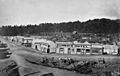
Aylmer Street, Ross, 1870. You can see the Morning Star mine in the background.
-
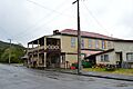
The historic Empire Hotel in Ross.
-

The peaceful Chinese Miners' Memorial Garden.
-
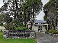
Ross School, the local primary school.
.jpg)


