
Haast Pass / Tioripatea facts for kids
Quick facts for kids Haast Pass / Tioripatea |
|
|---|---|

Gates of Haast
|
|
| Elevation | 562 m (1,844 ft) |
| Traversed by | State Highway 6 |
| Location | West Coast / Otago, New Zealand |
| Range | Southern Alps |
| Coordinates | 44°06′19″S 169°21′22″E / 44.105278°S 169.3561°E |

Haast Pass / Tioripatea
Location in New Zealand
|
|
The Haast Pass / Tioripatea is a special pathway through the Southern Alps mountains in the South Island of New Zealand. It's a low point between tall mountains that makes it easier to travel from one side to the other. Long ago, the Māori used this pass for their journeys.
The pass is named after Julius von Haast. He was a 19th-century explorer and a geologist, which means he studied rocks and the Earth. Later, the pass's name was officially changed to Haast Pass / Tioripatea. This happened after the Ngāi Tahu Claims Settlement Act 1998, which recognized the history and rights of the Ngāi Tahu Māori tribe.

Haast Pass is one of only three places where a road crosses over the Southern Alps. The other two are the Lewis Pass and Arthur's Pass. There's also the Homer Tunnel, which goes under the mountains. The road through Haast Pass, known as State Highway 6 (State Highway 6), was finished in 1966. By 1995, it had a smooth, sealed surface.
The highest point of the Haast Pass is 562 meters (about 1,844 feet) above sea level. This makes it the lowest of the passes that cross the Southern Alps. The road connects the valleys of the Haast River and the Makarora River. You won't find any towns or villages along the Haast Pass road between Haast and Makarora. The area around the pass is mostly covered in natural beech forests. The pass itself is inside Mount Aspiring National Park. It also marks the border between the Otago and West Coast areas.
History of the Pass
Long ago, the Ngāi Tahu Māori tribe used the Haast Pass. They traveled across it from Lake Wānaka to the West Coast. In 1835, a group led by Te Pūoho-o-te-rangi used the pass for a surprise journey. This allowed them to reach seasonal villages in the Makarora valley.
Europeans first learned about the pass in 1844. A Māori chief named Huruhuru drew a map for the explorer Edward Shortland. The first European to climb up to the pass from the Wānaka side was John Holland Baker in March 1861. He was looking for new land for sheep.
A gold prospector named Charles Cameron said he was the first European to cross all the way to the coast in 1863. However, many people believed he only reached the upper parts of the Haast River / Awarua. The first official crossing was made by Julius Haast in January 1863. He was a geologist for the Canterbury region. Haast led a team of five men. He named the Haast River after himself. After six weeks, he returned to Lake Wānaka, almost without shoes!
Images for kids
-
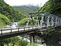
Gates of Haast
-
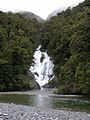
Fantail Falls, in the Haast Pass
