
Lake Wānaka facts for kids
Quick facts for kids Lake Wānaka |
|
|---|---|

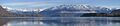
View of Lake Wānaka from Mt. Roy.
|
|

Lake Wānaka
Location in Otago peninsula
|
|

Location on the South Island
|
|
| Location | Queenstown-Lakes District, Otago, South Island |
| Coordinates | 44°30′S 169°08′E / 44.500°S 169.133°E |
| Primary inflows | Makarora River, Matukituki River |
| Primary outflows | Clutha River / Mata-Au |
| Basin countries | New Zealand |
| Max. length | 42 km (26 mi) |
| Max. width | 10 km (6.2 mi) |
| Surface area | 192 km2 (74 sq mi) |
| Average depth | 99 m (325 ft) |
| Max. depth | est. 311 m (1,020 ft) |
| Water volume | 19.01 km3 (4.56 cu mi) |
| Surface elevation | 278 m (912 ft) |
| Islands | Harwich Island, Mou Tapu, Mou Waho, Ruby Island, Stevensons Island |
Lake Wānaka is a beautiful lake in New Zealand. It is the fourth-largest lake in the country. The town of Wānaka sits right on its shores in the Otago region. The lake is about 278 meters (912 feet) above sea level. It covers a huge area of 192 square kilometers (74 square miles). The lake is also very deep, reaching more than 300 meters (984 feet) in some places.
The name "Wānaka" comes from the Māori language. It means "the lore of the tohunga or priest" or a "place of learning."
Contents
Geography of Lake Wānaka
Lake Wānaka is located in the middle of the Otago Lakes area. This is in the lower part of New Zealand's South Island. The town of Wānaka is built in a valley carved by glaciers. It is also the main entrance to Mount Aspiring National Park. Nearby, Lake Hāwea is just a 15-minute drive away. This is on the way to Makarora, a small town before the West Coast Glacier region. To the south, you can find the historic Cardrona Valley. This is a popular scenic route to Queenstown.
How Lake Wānaka Was Formed
Lake Wānaka sits in a U-shaped valley. This valley was carved out by huge glaciers. This happened during the last ice age, over 10,000 years ago. The lake gets its water from the Matukituki River and Makarora River. It is also the starting point for the Clutha River / Mata-Au.
The lake is about 42 kilometers (26 miles) long from north to south. At its widest point, which is at the southern end, it is 10 kilometers (6.2 miles) across. The western side of the lake has tall mountains. These mountains rise to over 2000 meters (6,560 feet) high. The eastern side is also mountainous, but the peaks are a bit lower.
Lake Hāwea is another lake nearby. It is in a valley next to Lake Wānaka. At their closest point, the two lakes are only 1000 meters (3,280 feet) apart. This narrow rocky ridge is called The Neck.
Islands in Lake Wānaka
Lake Wānaka has four small islands. These include Ruby Island, Stevensons Island, Mou Tapu, and Mou Waho (also known as Harwich Island). Some of these islands are special places for protecting nature. For example, Stevensons Island is home to buff weka birds. Mou Tapu island is 120 hectares (296 acres) big. It is a pest-free island. You can find mountain stone wētā and Southern Alps geckos there.
The towns of Wānaka and Albert Town are located near where the lake flows into the Clutha River / Mata-Au.
Human History of Lake Wānaka
Early Exploration and Settlement
For the Māori people, the Wānaka area was an important meeting point. The Haast Pass allowed them to reach the West Coast. This is where they found pounamu (greenstone). The Cardrona Valley led to a natural rock bridge called "Whatatorere". This was the only place to cross the Kawarau River and Mata-Au (the Clutha River) without boats. Māori used native reeds to build small boats called mōkihi. These boats helped them travel quickly downriver back to the east coast. The Cromwell basin used to have many moa birds. These large birds were hunted until they became extinct about 500 years ago.
Until the early 1800s, the Ngāi Tahu tribe visited Wānaka every year. They looked for pounamu in the mountains near the Haast River. They also hunted eels and birds during the summer. They would return to the east coast by floating down Mata-Au in their mōkihi boats.
According to the Ngāi Tahu stories, Lake Wānaka was created by the Waitaha explorer Rākaihautū. He used his special digging tool called kō, named Tūwhakaroria. After the Waitaha people arrived in New Zealand, Rākaihautū traveled down the middle of the South Island. As he went, he dug out the freshwater lakes.
Many Māori food-gathering places and settlements were located around the lake. The Kāti Māmoe settlement at the southern end was called Parakarehu. The Ngāi Tahu tribe took over this area in the early 1700s. Māori visits to the area stopped after attacks by tribes from the North Island in the 1830s.

The first map of Lake Wānaka was drawn in 1844. It was made by the Ngāi Tahu leader Te Huruhuru. The first European to see the lake was Nathanael Chalmers in 1853. He was guided by Reko and Kaikōura. By 1861, several sheep farms were set up around the southern end of the lake. In 1862, the lake itself was surveyed.
Names of the Lake and Town
The name "Lake Wanaka" was used in 1863. This was when the first survey for the town of Wanaka was done. The town was later renamed "Pembroke." But it changed back to "Wanaka" in 1940. This was to avoid confusion between the town and the lake.
In 2019, the official name of the lake was updated to "Lake Wānaka." The town's name was updated to "Wānaka" in 2021. These changes added the macron (the line above the 'a') to show the correct Māori pronunciation.
Current Use and Tourism

Today, Lake Wānaka is a very popular place for holidays. In the summer, people enjoy fishing, boating, and swimming. The mountains and fast-flowing rivers nearby offer exciting activities all year round.
Popular things to do include skiing and snowsports in winter. People also enjoy hiking, mountain-biking, mountaineering, rock-climbing, and parapenting (a type of paragliding).
Protecting Lake Wānaka
Lake Wānaka is special because its shoreline is still natural. It is one of the few lakes in the South Island like this. Because of this, it is protected by a special law called the Lake Wanaka Preservation Act of 1973. This law created a group called the 'Guardians of Lake Wanaka'. This group advises on how to keep the lake safe and healthy.
However, an invasive species called oxygen weed (Lagarosiphon major) has been a problem. This plant is usually found in aquariums. It has been growing in the lake's ecosystem. People have tried to get rid of it, but it keeps coming back. Large suction dredging operations have helped, but small bits of weed can still regrow.
Pūteketeke Conservation
In 2013, a zoologist named John Darby started the Lake Wānaka Grebe Project. This project put floating platforms on the lake. These platforms help the pūteketeke birds build their nests. This has led to more breeding pairs of these birds. The pūteketeke was even named New Zealand's Bird of the Year in 2023. This happened after a big campaign by British-American comedian John Oliver.
In Popular Culture
A willow tree growing in the lake is very famous. It is often called "That Wānaka Tree". It has become a popular spot for tourists to take photos. You can see it on many people's Instagram feeds.

Lake Wānaka in Films
The area around Lake Wānaka has been used as a setting for many international movies. Some famous films include The Lord of the Rings and The Hobbit. It was also featured in A Wrinkle in Time. Lake Wānaka was mentioned several times in the 2006 movie Mission: Impossible III.
The New Zealand cook and author Annabel Langbein owns a small property by the lake. She filmed her cooking shows The Free Range Cook and Simple Pleasures there.
Images for kids
-
View of Lake Wānaka, New Zealand
See also
 In Spanish: Lago Wānaka para niños
