
Kawarau River facts for kids
Quick facts for kids Kawarau River |
|
|---|---|

Kawarau River with Roaring Meg hydro station
|
|
| Country | New Zealand |
| Physical characteristics | |
| Main source | Lake Wakatipu |
| River mouth | Lake Dunstan |
| Length | 60 km (37 mi) |
The Kawarau River is a river found in the South Island of New Zealand. It starts from Lake Wakatipu in the Otago region. The river flows mostly east for about 60 kilometers (37 miles). It goes through the steep Kawarau Gorge before joining Lake Dunstan near Cromwell.
Two other rivers, the Shotover River and the Nevis River, also flow into the Kawarau. The Kawarau River has many fast-moving parts and strong currents. This makes it popular for exciting activities like bungy jumping and kayaking.
A special natural bridge called "Whatatorere" is found where the river becomes very narrow, only about 1.2 meters (4 feet) wide. This spot was very important long ago. It was the only place where people could cross the Kawarau and Clutha rivers without a boat. Early Māori used it on their journeys to find greenstone (pounamu). Later, gold miners used it to reach the goldfields.
Today, State Highway 6, a main road to Queenstown, runs through the Kawarau Gorge.
Contents
What's in a Name?
The name Kawarau comes from the Māori words meaning many shrubs. This name likely came from the native bushes that grew along the river a long time ago. However, many of the shrubs there now are not native to New Zealand.
River History
In the 1800s, people found a lot of gold in the Kawarau River. They used a method called placer mining to get the gold from the riverbed. You can still visit the Goldfields Mining Centre today. It shows how gold mining was done in the 19th century. Some old miners' huts are still there, often near busy vineyards.
In 1924, a company tried to drain the river. Their goal was to block off Lake Wakatipu and then collect gold from the dry riverbed. They built ten huge gates, which were finished in 1927. The river level did drop, but it didn't dry up completely as they had hoped. These gates were part of State Highway 6 until a new bridge was built in 2017.
Protecting the River
A special rule called a Water Conservation Order was put in place in March 1997. This rule helps protect the Kawarau River and its smaller rivers from having new hydroelectric dams built on them. This order covers the river from the Lake Wakatipu control gates down to Scrubby Stream.
Adventure and Tourism
The first European to visit this area was Nathanael Chalmers in 1853. He was guided by Māori Chiefs Reko and Kaikoura. They showed him the "Whatatorere" rock bridge at Roaring Meg. This was the only place to cross the Kawarau River back then.
| Early adventure tourism? |
|---|
| In 1910, Nathanael Chalmers remembered his raft trip through the Cromwell Gorge: ‘I shall never forget the “race” through the gorge ... my heart was literally in my mouth, but those two old men seemed to care nothing for the current.’ |

Today, the Kawarau River is famous for adventure activities. These include riverboarding, jet boating, white water rafting, and river surfing. The Kawarau Gorge Suspension Bridge is 43 meters (141 feet) above the river. It is a historic place and the site of the world's first commercial bungy jumping business.
The Kawarau is the biggest river in New Zealand for commercial rafting. It has an average flow of 216 cubic meters per second (7,600 cubic feet per second). There are four main rapids used for rafting: Smiths Falls, Twin Bridges, Do Little Do Nothing, and the 400-meter (1,300-foot) Chinese Dog Leg. Some parts of the river, like Nevis Bluff, Citroen, and Roaring Meg, are very dangerous.
Bridges Over the Kawarau
Several bridges cross the Kawarau River:
- Kawarau Gorge Suspension Bridge
- Kawarau River Bridge
- Kawarau River (Victoria) Bridge
- Kawarau Falls Bridge
- A bridge at the Goldfields Mining Centre
The natural rock bridge "Whatatorere" at Roaring Meg was the only way to cross the Kawarau River and Clutha River / Mata-Au without a boat until it was destroyed in the 1800s.
Images for kids
-
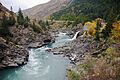
Kawarau River with Roaring Meg hydro station
-
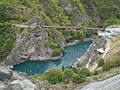
Kawarau Bridge Bungy, the world's first commercial bungy site. The A. J. Hackett Bungy Centre is on the right.
See also
 In Spanish: Kawarau River para niños
