
Cromwell, New Zealand facts for kids
Quick facts for kids
Cromwell
Tīrau (Māori)
|
|
|---|---|
|
Town
|
|
 |
|
| Country | New Zealand |
| Region | Otago region |
| Territorial authority | Central Otago District |
| Ward | Cromwell Ward |
| Community | Cromwell Community |
| Electorates |
|
| Area | |
| • Total | 15.63 km2 (6.03 sq mi) |
| Elevation | 210 m (690 ft) |
| Population
(June 2023)
|
|
| • Total | 7,160 |
| • Density | 458.1/km2 (1,186.5/sq mi) |
| Time zone | UTC+12 (NZST) |
| • Summer (DST) | UTC+13 (NZDT) |
| Postcode(s) |
9310
|
| Local iwi | Ngāi Tahu |

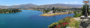
Cromwell is a lively town in the Central Otago region of New Zealand's South Island. Its Māori name is Tīrau. The town sits on the shores of Lake Dunstan, where the Kawarau River flows into the lake.
Cromwell started during the exciting Otago gold rush. Today, it's famous for its delicious wines and fresh fruit. In 2018, about 5,610 people called Cromwell home.
Contents
What's in a Name?
Māori Name: Tīrau
The Māori people called this area "Tīrau." This name comes from the Ti or cabbage trees they planted. These trees were used as important navigation markers. They also provided food for people traveling through the area.
European Names and the Name Cromwell
Early European gold miners had different names for the area. They called it "The Junction," "The Point," or "Kawarau Junction." This was because it was where the Clutha River / Mata-Au and the Kawarau River met.
The town was officially named Cromwell in 1863. A man named J. A. Connell chose the name. He was from Northern Ireland and decided to name it after Oliver Cromwell.
Exploring Cromwell's Location
Cromwell is located between two important highways. State Highway 6 connects it to Wānaka (about 50 km north) and Queenstown (about 60 km west). State Highway 8 leads to the Lindis Pass (about 75 km northeast) and Alexandra (about 33 km south). The road to Alexandra goes through the scenic Cromwell Gorge.
Cromwell is one of the furthest places from the sea in New Zealand. It is about 119 kilometers away from the coast.
Lake Dunstan and Mountains
A big feature of Cromwell is the human-made Lake Dunstan. This lake was created when the Clyde Dam was built.
Mountains surround Cromwell. To the north, you'll find the Pisa Range. The Dunstan Mountains are to the northeast. Mount Difficulty is to the west, and the Old Woman Range is to the south.
Nearby Towns and Special Features
Small towns like Bannockburn, Lowburn, Tarras, and Ripponvale are close by. Cromwell is a central point for travel between Wānaka, Queenstown, and Alexandra.
Cromwell is also home to a special insect, the Cromwell Chafer Beetle (Prodontria lewisi). The 45th parallel south line, which is halfway between the Equator and the South Pole, runs just north of the town.
Before the Clyde Dam was built, the Clutha and Kawarau Rivers met here. Their waters were different colors, and there was an old bridge. The dam's construction in the early 1990s flooded this area, including the old town center.
Cromwell's Weather
Cromwell gets about 400 mm of rain each year. This is because it's located far inland. The town has an oceanic climate, which means it has mild temperatures and enough rain.
| Climate data for Cromwell (1991–2020 normals, extremes 1949–present) | |||||||||||||
|---|---|---|---|---|---|---|---|---|---|---|---|---|---|
| Month | Jan | Feb | Mar | Apr | May | Jun | Jul | Aug | Sep | Oct | Nov | Dec | Year |
| Record high °C (°F) | 36.6 (97.9) |
36.4 (97.5) |
32.7 (90.9) |
27.8 (82.0) |
24.0 (75.2) |
21.0 (69.8) |
18.8 (65.8) |
22.3 (72.1) |
26.0 (78.8) |
30.0 (86.0) |
33.3 (91.9) |
33.8 (92.8) |
36.6 (97.9) |
| Mean daily maximum °C (°F) | 24.9 (76.8) |
24.7 (76.5) |
21.9 (71.4) |
17.8 (64.0) |
13.2 (55.8) |
9.0 (48.2) |
9.1 (48.4) |
12.2 (54.0) |
15.5 (59.9) |
18.1 (64.6) |
20.6 (69.1) |
23.2 (73.8) |
17.5 (63.5) |
| Daily mean °C (°F) | 17.9 (64.2) |
17.6 (63.7) |
14.9 (58.8) |
11.0 (51.8) |
7.7 (45.9) |
4.3 (39.7) |
3.9 (39.0) |
6.2 (43.2) |
9.3 (48.7) |
11.7 (53.1) |
13.9 (57.0) |
16.4 (61.5) |
11.2 (52.2) |
| Mean daily minimum °C (°F) | 10.9 (51.6) |
10.5 (50.9) |
7.8 (46.0) |
4.3 (39.7) |
2.2 (36.0) |
−0.3 (31.5) |
−1.3 (29.7) |
0.2 (32.4) |
3.0 (37.4) |
5.2 (41.4) |
7.2 (45.0) |
9.5 (49.1) |
4.9 (40.9) |
| Record low °C (°F) | 0.0 (32.0) |
−0.4 (31.3) |
−3.4 (25.9) |
−6.0 (21.2) |
−9.1 (15.6) |
−10.0 (14.0) |
−9.0 (15.8) |
−8.8 (16.2) |
−7.2 (19.0) |
−9.6 (14.7) |
−4.2 (24.4) |
−0.2 (31.6) |
−10.0 (14.0) |
| Average rainfall mm (inches) | 47.2 (1.86) |
38.9 (1.53) |
31.5 (1.24) |
34.0 (1.34) |
38.2 (1.50) |
33.9 (1.33) |
25.1 (0.99) |
25.7 (1.01) |
25.7 (1.01) |
27.0 (1.06) |
34.2 (1.35) |
37.0 (1.46) |
398.4 (15.68) |
| Mean monthly sunshine hours | 256.1 | 235.4 | 222.0 | 172.3 | 119.9 | 94.8 | 108.2 | 156.8 | 188.8 | 223.8 | 238.4 | 251.8 | 2,268.3 |
| Source: NIWA | |||||||||||||
Cromwell's Past: A Glimpse into History
Early Explorers and Gold Discovery
The first European to visit Cromwell was Nathanael Chalmers in 1853. He was guided by Māori locals, Reko and Kaikōura.
In 1862, gold was found near Cromwell by two miners, Horatio Hartley and Christopher Reilly. When news of the gold spread, thousands of miners rushed to the area. Cromwell quickly grew, even having nine hotels!
Town Growth and Changes
Cromwell became an official town in 1866. The government built a bridge across the Clutha River in 1866. The town's newspaper, The Cromwell Argus, started in 1869. A hospital was also built in 1875.
The population of Cromwell was 424 people in 1878. It grew slightly to 429 people by 1881. Later, large companies used dredges to mine for gold, but this didn't last long.
A railway station opened in Cromwell in 1921, connecting it to Dunedin. However, it closed in 1976.
Wars and Farming
Soldiers from Cromwell fought in World War I, and 13 of them sadly lost their lives. A memorial was put up in 1923 to remember them. Another 11 soldiers from Cromwell died during World War II. A special hall was built in the 1950s to honor all those who served.
As gold mining slowed down, Cromwell became a center for farming. It also became known for growing stone fruit like peaches and apricots. An irrigation system was built in the 1920s to help water the fruit orchards.
The Giant Fruit Sculpture

To celebrate its fruit industry, Cromwell has a huge sculpture of stone fruit. It was built by the Cromwell Rotary Club in 1990. This giant fruit sculpture is a famous landmark in the town.
The Clyde Dam and New Cromwell
A big change for Cromwell was the decision to build the Clyde Dam. This project meant that about one-third of the old town would be flooded.
Many homes and businesses had to be moved to higher ground. The old town center was relocated between 1984 and 1985. This new area is now called "The Mall." Some of the old buildings that weren't flooded were kept. They form a special historic area near the lake.
Lake Dunstan began to fill in 1992. This flooded about 2,000 hectares of land, including farms and orchards. Cromwell is sometimes called the "Fruit Bowl of the South" because of its fruit growing.
Cromwell Today: What to See and Do
Fun Places to Visit
- Highlands Motorsport Park: On the edge of Cromwell, this park has a race track and a cool museum with classic cars.
- Cromwell Museum: This museum tells the story of Cromwell. It has items from Chinese gold miners, old household tools, and photos of the town. It moved in 1988 because of the lake filling up.
- Cromwell Swimming Pool: This indoor pool complex has a 25-meter pool, a learners' pool, and a toddler's pool. It's a great place to swim all year round.
- Kiwi Water Park: Just outside Cromwell, this park has inflatable obstacles and water toys. It's a popular spot for fun in the summer!
- Cromwell Public Library: Located at The Mall, the library offers books, magazines, DVDs, and computers. It's a quiet place to read or study.
Sports and Outdoor Adventures
- Rugby: The Cromwell rugby club started in 1888. They have had many successful teams over the years.
- Mountain Biking: The Lake Dunstan mountain bike trail opened in 2021. It's 55 kilometers long and connects Cromwell to Clyde. Some parts of the trail have exciting cantilevered platforms that hang over cliffs! There are also other trails in the area, and plans for a new mountain bike park.
- Cromwell Golf Club: The golf course was redesigned in 2010. It's an 18-hole course and has hosted many important golf events.
- Cromwell Bowling Club: This club has an artificial green, which means they can play bowls for ten months of the year.
- Cromwell Racecourse: Horse racing has happened here since 1862. The racecourse is also used for concerts and other events. The Cromwell gallops race meeting has been held every year for over 150 years!
Historic Buildings and Sites
Cromwell Heritage Precinct

When Lake Dunstan was created, part of the old Cromwell town was flooded. Some historic buildings were saved or rebuilt. They now form the heritage precinct, showing what the old town looked like.
Old Churches
- Former St John's Presbyterian Church: This church was built in 1872 using local stone. It has a Gothic style. It closed in 2004 and is now a protected historic place.
- Mary Immaculate and the Irish Martyrs Catholic Church: Opened in 1909, this church has a tall belltower with an orange roof. It was considered the most beautiful building in Cromwell when it was built.
- St Andrew's Anglican Church: This Gothic-style church opened in 1874. Local residents helped raise money and donated land for its construction.


Other Historic Spots
- Athenaeum Hall: Built in 1874, this hall used to house the Cromwell Museum. It was partly buried by earthworks during the dam construction.
- Litany Street Cemetery: This was Cromwell's first cemetery, started in 1865. Many early gold miners, including Chinese immigrants, are buried here.
- Former Cromwell Courthouse: Built in 1872, this building served as the courthouse for over 100 years. It is now privately owned and is a protected historic place.

Nearby Gold Mining Areas
- Bannockburn: Bannockburn is a small town about 5.8 km from Cromwell. It was once a busy gold mining center. You can walk to Bannockburn on a lakeside trail. The Bannockburn sluicings show old dams, tunnels, and shafts from the gold mining days.
- Bendigo Goldfields: This area was successful for quartz mining for over 50 years. You can find remains of old stone cottages from former mining towns like Logantown and Welshtown.
- Carrick Goldfields: Here you can see the ruins of Carricktown and the Young Australian 6-meter water-wheel, which was used for mining.
Learning in Cromwell
Cromwell has several schools and a polytechnic.
- The first school opened in Cromwell in 1865.
- Cromwell Primary School is for students in Year 1 to 6.
- Goldfields School is also for students in Year 1 to 6.
- Cromwell College is a secondary school for students in Year 7 to 13.
- Otago Polytechnic has a campus in Cromwell. It specializes in subjects like horticulture (growing plants), catering, and tourism.
Images for kids
-
Cromwell Station Yard Plan

