Clutha River facts for kids
Quick facts for kids Clutha River |
|
|---|---|
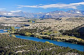
Upper Clutha Valley, looking upriver toward the Southern Alps / Kā Tiritiri o te Moana
|
|
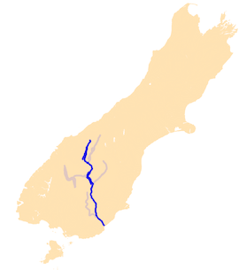
The Clutha River system.
|
|
| Native name | Mata-Au |
| Other name(s) | Mata-Au |
| Country | New Zealand |
| Region | Otago |
| Physical characteristics | |
| Main source | Mount Brewster Southern Alps / Kā Tiritiri o te Moana |
| River mouth | Pacific Ocean Sea level 46°21′S 169°48′E / 46.350°S 169.800°E |
| Length | 338 km (210 mi) |
| Depth |
|
| Basin features | |
| Progression | Makarora River → Clutha River |
| Basin size | 21,960 km2 (8,480 sq mi) |
| Waterbodies | Lake Wānaka, Lake Dunstan, Lake Roxburgh |
| Islands | Inch Clutha |
The Clutha River, also known as Mata-Au in Māori, is a very important river in New Zealand. It's the second longest river in the whole country and the longest in the South Island.
This powerful river flows for about 338 kilometres (210 mi) from Lake Wānaka in the Southern Alps / Kā Tiritiri o te Moana all the way to the Pacific Ocean. It's known for being New Zealand's highest volume river, meaning it carries the most water. It's also one of the fastest-flowing rivers in the world!
The Clutha / Mata-Au is famous for its beautiful scenery, its history linked to the gold rush, and its bright turquoise waters. Both its English name "Clutha" and its Māori name "Mata-Au" are officially recognised as equally important.
Contents
Exploring the Clutha River's Path
The Clutha River starts high up in the mountains, near the Haast Pass. Its water first flows into Lake Wānaka. From the southern end of Lake Wānaka, the Clutha River begins its journey.
Near Albert Town, the Hāwea River joins the Clutha. This river flows out of Lake Hāwea, which is like a twin lake to Lake Wānaka. The Cardrona River also adds its waters soon after.
The river then rushes through the Upper Clutha Valley. It passes through a winding section known as the 'Snake'. Near Luggate, there's a unique bend called the "Devil's Nook". The river narrows as it goes through the Māori Gorge.
River Journey to the Sea
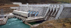
Further downstream, the Lindis joins the Clutha. The river then widens into Lake Dunstan. This lake was created by the huge Clyde Dam, which generates hydroelectricity (power from water).
About 50 kilometres (31 mi) from Lake Wānaka, the Clutha meets the Kawarau River at Cromwell. Before the Clyde Dam was built in 1992, people noticed how different the colours of these two rivers were when they met.
After the Kawarau, the Clutha flows through the Cromwell Gorge to Clyde and Alexandra. Here, the Manuherikia River adds its water. South of Alexandra, the river forms another artificial lake, Lake Roxburgh, behind the Roxburgh Dam. This dam also creates electricity.
The town of Roxburgh is about 120 kilometres (75 mi) downstream from Lake Wānaka. From Roxburgh, the river continues past towns like Ettrick and Millers Flat. It then flows through the Rongahere Gorge, which is known for its native bush (forest).
The Tuapeka River joins the Clutha at Tuapeka Mouth. The river then turns south and is joined by its last major tributary, the Pomahaka River. This is about 30 kilometres (19 mi) from the coast.
Finally, the river passes Balclutha and spreads out into the Clutha delta. This delta has a large, flat island called Inch Clutha. Here, the river splits into two main branches. The northern branch is called the Matau, and it flows past Kaitangata. The southern branch is called the Koau. Both branches flow into the Pacific Ocean at Molyneux Bay.
How Fast and Clear is the Clutha?
The Clutha River is famous for being incredibly fast-flowing. It carries a huge amount of water, about 614 cubic metres per second (21,700 cu ft/s) on average. This makes it one of the world's swiftest rivers, even though it's not the longest. The highest flow ever recorded was during heavy storms in June 2015, reaching 1,621 cubic metres per second (57,200 cu ft/s).
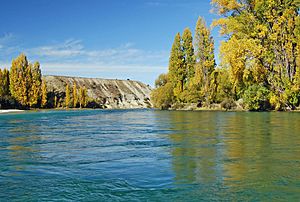
The water in the upper part of the Clutha is a beautiful clear turquoise colour. This happens because the water comes from glaciers and melting snow, and it gets filtered as it flows through Lake Wānaka. This clear, high-volume water is quite rare! However, after the Kawarau River joins at Cromwell, the water becomes less turquoise because the Kawarau carries more silt.
The River's Hidden Path in the Ocean
The Clutha River doesn't just stop at the coast. Underwater, a huge canyon system extends for over 100 kilometres (62 mi) into the Pacific Ocean. This underwater canyon looks a lot like the river and its branches on land. Many smaller rivers along the Otago coast can almost be thought of as part of this underwater Clutha system.
The rocks in the Clutha's area are mostly quartz and schist. This means the river carries white quartz sand downstream to the beaches. Ocean currents then carry this sand further north, even to beaches near Dunedin. However, the Roxburgh Dam has stopped some of this sand from reaching the coast, which can cause beaches to erode.
Clutha River History
The Māori people originally knew the river as Mata-au. This name means "current" or "eddy" in a large body of water. One of the river's branches in the delta is still called Matau today.
The English name "Clutha" comes from Cluaidh, which is the Scottish Gaelic name for the River Clyde in Scotland. Early European explorers, like Captain Cook, called it the Molyneux.
Long ago, the upper parts of the river were home to many flightless moa birds. These birds were hunted by the giant Haast's eagle. When Europeans first arrived, there was a Māori settlement of about 250-300 people living near the river.
In the early days of European settlement, a whaling station was set up near the river's mouth at Port Molyneux. At that time, the ocean and whaling were very important for the local economy.
The Gold Rush Era
The Clutha River played a huge role in the Central Otago goldrush. The first major gold discoveries in Otago happened near the Tuapeka River at Gabriel's Gully in 1861. The next year, even more gold was found near where Cromwell is today.
By Christmas 1861, about 14,000 gold prospectors were working in the area. The main gold rush for easily found gold didn't last long, mostly ending by 1863. But more miners kept arriving, with a peak of 18,000 miners in February 1864.
Major Floods on the Clutha
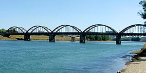
The Clutha River has had several very large floods. Two of the most famous were the "Hundred year floods" in October 1878 and October 1978.
The 1878 flood is considered the biggest known flood in New Zealand's history. During this flood, a bridge at Clydevale was washed away. It then crashed into the Balclutha Road Bridge, destroying it too. The flood also changed the river's path near its mouth, creating two new outlets to the sea. The busy town of Port Molyneux, which was at the old river mouth, became much smaller and no longer exists today.
The 1978 flood caused rivers to overflow from the south to the Tokomairaro River. Over 12,000 hectares (30,000 acres) of land was covered in water, and more than 21,000 farm animals were lost. Many towns were affected, including Balclutha and Milton. The small settlement of Kelso was completely abandoned and never rebuilt after the waters went down. At its highest, the Clutha's flow was over 4,500 cubic metres per second (160,000 cu ft/s).
Another big flood in 1999 caused serious damage, especially in Alexandra. This flood was partly blamed on the riverbed rising in the Roxburgh reservoir, which is behind the Roxburgh Dam. Even though the 1999 flood had less water volume than the 1878 flood, the water levels in Alexandra were much higher.
How People Use the Clutha River
The Clutha River is very important for generating electricity. There are two large hydroelectric power stations on the river: the Clyde Dam and the Roxburgh Dam. These dams help provide electricity for New Zealand. Other dams were planned in the past but were not built.
Many towns along the Clutha River use its water for their drinking water supply. The water is treated to make it safe to drink.
The river also provides water for irrigation. This helps grow delicious stone fruit like apples, apricots, and cherries, as well as grapes for wine in areas like Cromwell, Alexandra, and Roxburgh. There are also many vineyards further up the river near Wānaka.
Fun Activities on the Clutha
The beautiful scenery of Central Otago makes the upper Clutha / Mata-Au a popular place for holidays and adventure tourism. People enjoy activities like jetboating, kayaking, rafting, riverboarding, and fishing. You can also find operators offering waterskiing, tandem parachuting, and paragliding.
The upper Clutha / Mata-Au is also used for multi-sport events. Lake Dunstan is a great place for rowing. In the mountains at the top of the river's area, there are major ski fields where people can go skiing. During the cold Central Otago winters, people also play curling near the river.
See also
 In Spanish: Río Clutha para niños
 | Kyle Baker |
 | Joseph Yoakum |
 | Laura Wheeler Waring |
 | Henry Ossawa Tanner |


