Lake Roxburgh facts for kids
Quick facts for kids Lake Roxburgh |
|
|---|---|
 |
|
| Location | Central Otago District, Otago Region, South Island |
| Coordinates | 45°28′16″S 169°19′41″E / 45.471°S 169.328°E |
| Type | Artificial lake |
| Primary inflows | Clutha River |
| Primary outflows | Clutha River |
| Basin countries | New Zealand |
| Surface area | 6 km2 (2.3 sq mi) |
| Surface elevation | 132 m (433 ft) |
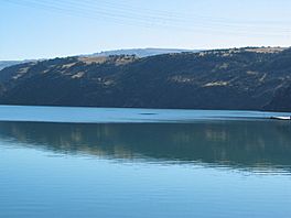
Lake Roxburgh is a special kind of lake in New Zealand. It's not a natural lake, but one made by people! It was created when the huge Roxburgh Dam was built. This dam was one of the very first big projects to make electricity from water in the southern part of New Zealand's South Island.
Discover Lake Roxburgh
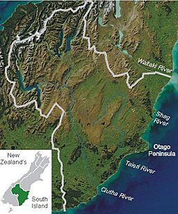
Lake Roxburgh sits on the Clutha River. This river is one of the longest and fastest in New Zealand. The lake is about 160 kilometers (100 miles) away from the city of Dunedin.
How Big Is Lake Roxburgh?
The lake covers an area of about 6 square kilometers (2.3 square miles). It stretches for almost 30 kilometers (19 miles) towards the town of Alexandra. The town of Roxburgh is located about 5 kilometers (3 miles) south of the dam itself.
Why Was Lake Roxburgh Created?
Lake Roxburgh is an example of an artificial lake or reservoir. It was made to help generate hydroelectricity. Hydroelectricity is a clean way to make power using the force of moving water. The Roxburgh Dam holds back the Clutha River, creating the lake. Then, water is released through turbines in the dam. These turbines spin and create electricity for homes and businesses.
This project was very important for New Zealand. It helped provide power to many people, especially in the South Island. It was one of the first large-scale efforts to use the country's rivers for energy.
 | George Robert Carruthers |
 | Patricia Bath |
 | Jan Ernst Matzeliger |
 | Alexander Miles |


