Roxburgh, New Zealand facts for kids
Quick facts for kids
Roxburgh
|
|
|---|---|
|
Town
|
|

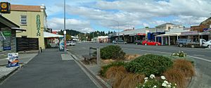
The main street of Roxburgh
|
|
| Country | New Zealand |
| Region | Otago region |
| Territorial authorities | Central Otago District |
| Ward | Teviot Valley Ward |
| Community | Teviot Valley Community |
| Electorates |
|
| Area | |
| • Urban area | 2.34 km2 (0.90 sq mi) |
| Population
(June 2023)
|
|
| • Urban area | 660 |
| • Density | 282.1/km2 (731/sq mi) |
| Time zone | UTC+12 (NZST) |
| • Summer (DST) | UTC+13 (NZDT) |
| Postcode |
9500
|
| Area code | 03 |
| Local iwi | Ngāi Tahu |
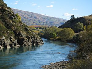
Roxburgh is a small town in Central Otago, New Zealand. It used to be called Teviot or Teviot Junction. About 600 people live there. The town sits in the Teviot Valley next to the Clutha River. It is about 40 kilometres (25 miles) south of Alexandra in the South Island.
State Highway 8 goes through Roxburgh. This road connects Central Otago with Dunedin city. Roxburgh is famous for its delicious summer fruit, like apples, cherries, and apricots. It is also known for "Jimmy's Pies."
Roxburgh was important during the Otago gold rush in the 1860s. Today, the town's economy relies on farming animals and growing fruit. It is a major area for growing apples in New Zealand.
Just 5 kilometres (3 miles) north of Roxburgh is the Roxburgh Dam. This was one of the first big hydroelectric dams built on the Clutha River. There is also a mine nearby at Coal Creek where they dig up lignite, a type of coal.
Contents
History of Roxburgh
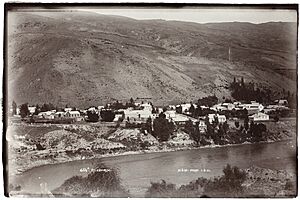
The town was first known as Teviot. From 1863 to 1866, it was called Teviot Junction. Today, the name Teviot is used for the valley and a river. The name Roxburgh was officially chosen on April 18, 1877. This name comes from Roxburghshire in Scotland, where some of the first European settlers came from.
The Roxburgh Railway Line
From 1928 to 1968, a branch line railway served Roxburgh. This line connected the town to the main railway network. The railway tracks did not go right into the town. Instead, the station was about 2 kilometres (1.2 miles) south of Roxburgh at a place called Hercules Flat.
The railway line often lost money, but it helped Roxburgh grow. It was very important for bringing materials to build the Roxburgh Dam. Today, you can still see parts of the old railway station. There is a pit where trains used to turn around and a water tower for steam locomotives. The old station building is now used as a hay shed. Many houses where railway workers lived are still there, owned by private people.
Roxburgh War Memorial
The Roxburgh War Memorial was opened on May 24, 1923. It is a tall, square stone monument. It lists the names of 42 men from Roxburgh and the local area who died in World War One and World War Two.
When it was first put up, the memorial included a German mortar and a machine gun. The mortar was captured by New Zealand soldiers in 1918. The machine gun was stolen in the 1970s. The mortar was moved on March 16, 2003, when a new plaque was placed near the Council Building.
Roxburgh in Film
Some parts of the 2004 movie In My Father's Den were filmed in Roxburgh.
People of Roxburgh
Roxburgh is a rural settlement. In 2018, it had a population of 588 people. This was an increase of 60 people since 2013. The town covers an area of about 2.34 square kilometres (0.90 square miles).
Most people in Roxburgh are of European descent (86.7%). About 14.8% are Māori, and smaller numbers are Pasifika or Asian. Many people (44.9%) said they had no religion. About 44.4% were Christian.
Entertainment in Roxburgh

Roxburgh has the oldest working cinema in New Zealand. It first opened on December 11, 1897, on Scotland Street. It can seat 258 people. It is one of only four cinemas left in Central Otago. Sometimes, live shows are also held there.
Education in Roxburgh
Roxburgh Area School is a school for students from Year 1 to Year 13 (ages 5 to 18). It is a co-educational school, meaning both boys and girls attend. The school has about 375 students.
Education in the Roxburgh area began in 1865. There were other schools in nearby areas like Coal Creek Flat. Roxburgh District High School started in 1926. In 1976, it changed its name to Roxburgh Area School.
Roxburgh Climate
Roxburgh has a varied climate. Summers are warm, and winters are cool. The average high temperature in January (summer) is about 23.2°C (73.8°F). In July (winter), the average high is about 8.7°C (47.7°F). Rainfall is spread throughout the year.
| Climate data for Roxburgh Power Station (1981–2010) | |||||||||||||
|---|---|---|---|---|---|---|---|---|---|---|---|---|---|
| Month | Jan | Feb | Mar | Apr | May | Jun | Jul | Aug | Sep | Oct | Nov | Dec | Year |
| Mean daily maximum °C (°F) | 23.2 (73.8) |
22.9 (73.2) |
20.5 (68.9) |
17.3 (63.1) |
12.8 (55.0) |
9.5 (49.1) |
8.7 (47.7) |
11.9 (53.4) |
14.9 (58.8) |
17.4 (63.3) |
19.6 (67.3) |
21.2 (70.2) |
16.7 (62.0) |
| Daily mean °C (°F) | 16.6 (61.9) |
16.1 (61.0) |
14.0 (57.2) |
11.0 (51.8) |
8.0 (46.4) |
5.3 (41.5) |
4.6 (40.3) |
6.6 (43.9) |
9.1 (48.4) |
11.2 (52.2) |
13.0 (55.4) |
15.0 (59.0) |
10.9 (51.6) |
| Mean daily minimum °C (°F) | 9.9 (49.8) |
9.2 (48.6) |
7.4 (45.3) |
4.8 (40.6) |
3.1 (37.6) |
1.2 (34.2) |
0.3 (32.5) |
1.3 (34.3) |
3.3 (37.9) |
5.0 (41.0) |
6.5 (43.7) |
8.9 (48.0) |
5.1 (41.1) |
| Average rainfall mm (inches) | 42.4 (1.67) |
33.3 (1.31) |
52.7 (2.07) |
35.7 (1.41) |
47.9 (1.89) |
32.1 (1.26) |
35.7 (1.41) |
26.4 (1.04) |
33.5 (1.32) |
46.7 (1.84) |
36.7 (1.44) |
57.5 (2.26) |
480.6 (18.92) |
| Source: NIWA (rainfall 1971–2000) | |||||||||||||
 | Victor J. Glover |
 | Yvonne Cagle |
 | Jeanette Epps |
 | Bernard A. Harris Jr. |


