Milton, New Zealand facts for kids
Quick facts for kids
Milton
|
|
|---|---|
|
Town
|
|
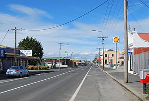
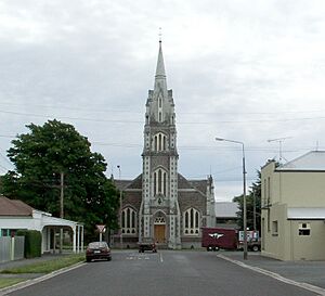
Milton Union Street in 2012
|
|
| Country | New Zealand |
| Region | Otago |
| Territorial authority | Clutha District |
| Ward | Bruce |
| Electorates |
|
| Area | |
| • Total | 4.16 km2 (1.61 sq mi) |
| Population
(June 2023)
|
|
| • Total | 2,240 |
| • Density | 538.5/km2 (1,395/sq mi) |
| Time zone | UTC+12 (NZST) |
| • Summer (DST) | UTC+13 (NZDT) |
| Postcode |
9220
|
| Area code(s) | 03 |
| Local iwi | Ngāi Tahu |
Milton is a town in Otago, New Zealand. It's home to over 2,000 people. You can find it about 50 kilometres south of Dunedin on State Highway 1.
The town sits on the flat land near the Tokomairaro River. This river has a special connection to Milton. It even gives its name to the town's high school, Tokomairiro High School.
Milton started as a town for milling in the 1850s. There's been a long discussion about how it got its name. The streets in Milton are named after famous British poets. It's thought that the town's first name, "Milltown," might have been shortened to Milton because of the famous poet John Milton. Or, maybe the name Milton came first, and that's why they chose poets' names for the streets.
Contents
History of Milton
Milton's early days were greatly changed by the Otago gold rush. This happened when Gabriel Read found gold near Lawrence. Milton was on an easy path to the goldfields. Because of this, it grew a lot during the gold rush in the 1860s. It became a main stop for gold seekers on their way to find riches.
The town first began in a place called Fairfax. This settlement was at the bottom of the hills southeast of Milton. As it became more important to connect with the goldfields, the town spread onto the plains by the river. A beautiful Gothic church, Tokomairiro Presbyterian Church, was built then by architect R A Lawson. When it was built, this church was the tallest building so far south in the world.
Today, the church is still the most famous landmark in Milton. You can see it from many kilometres away across the Tokomairiro Plains. It was placed at the end of the main road from Fairfax to the goldfields. This made it a grand building that stood out on the road.
Milton was very important in early Otago. This was mainly because it was on the way to the goldfields. It also had the Bruce Woollen Mills, which were some of the biggest factories in the area. Another important business was the Kiwi Bacon Factory. It had a branch in Milton until the early 1980s.
Milton was also important for communication. In February 1878, it was one of the first two towns to get a long-distance telephone line. This line connected Milton and Dunedin. Milton was a bigger town than Balclutha for a long time. But Balclutha grew much larger in the early 1900s.
Education was also important in early Milton. The Tokomairiro School started in 1856. This was only eight years after the province itself began. It was one of the best schools in the province for many years. Today, it's split into Tokoiti School and Tokomairiro High School. Electric lights were put in the town in 1919.
Milton's Railway History
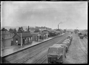
Milton got connected to the national railway system in the early 1870s. The Main South Line was built through the town. Goods trains started running in October 1874. The line officially opened from Green Island to Balclutha on September 1, 1875.
Milton became a railway junction in 1907. An extension of the Roxburgh Branch line was built next to the Main South Line. This helped trains run better. But in 1960, Milton lost this status. The extension was removed, and the Roxburgh Branch junction went back to Clarksville.
The Main South Line still goes through Milton. However, the station stopped having passenger trains on December 1, 1970. The Southerner train, which replaced the old service, did not stop in Milton.
The Milton station had a shed for two engines. It also had a long passenger platform and a goods shed. There was a loading area, cattle yards, and a stationmaster's house. From 1895 to 1957, there was a refreshment room. A bookstall was added in 1897.
A large turntable was put in place in 1927. There were fires at the engine shed in 1938 and 1959. In 1959, two A Class locomotives in the shed were not harmed. There was also a fire at the station in 1942 and in a large shed in 1944.
The stockyards closed in 1971. The station building, platform, and goods sheds were still there in 1988. But by 1995, they were gone.
Coal Mines and Railway Line
People started digging for coal in the Tokomairaro valley in 1855. A railway for coal was thought about as early as 1875. Mining near Fortification Hill began in 1882. It was hard to get coal out because of bad roads and tricky river navigation.
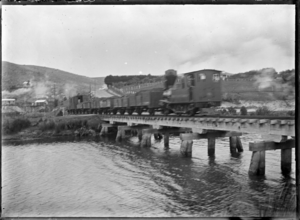
The Fortification Railway and Coal Company started building a railway in 1900. It opened on April 3, 1901. But the company closed in 1903. In 1906, the Bruce Coal Company Ltd opened a new mine called Waronui. It was across the river. A temporary bridge was built over the river. The railway was then extended to the new mine in 1908.
The railway line ran southwest from Milton for about 6 miles (10 km). It crossed the Tokomairaro River a few times. It went to mines at Fortification and Waronui. The line was not used much after two miners died in 1930. It was sold for scrap in 1932.
Milton Pottery Works
Milton was once famous for its pottery. Many people thought it was some of the best in the country. Clay is easy to find in South Otago. Pottery factories were a big employer in the late 1800s across South Otago and Southland.
From 1873 to 1915, many pottery businesses worked in the Milton area. William White's Tokomairiro Steam Pottery Works started first. It's said to have had the first industrial kilns in the Southern Hemisphere.
The Milton Pottery works was saved in 1880 by Charles Reeves. He was a former Mayor of Dunedin. The pottery industry was at its busiest in the 1880s. At that time, five kilns were running, and over 40 people worked there. They made building materials like bricks and tiles. They also made bathroom items like washbasins. And they created dishes, vases, and jars for homes and decoration.
The pottery industry in Milton did not last after World War I. Many workers left for the war. But pottery continued in South Otago at Benhar, near Balclutha. Benhar was a major maker of toilet bowls and other home ceramics until the 1990s.
The Bruce Herald Newspaper
The Bruce Herald was a newspaper started by Joseph Angus Mackay in 1864. It was one of the longest-running country newspapers. It closed on October 7, 1971. It was part of a group of newspapers. This group included Mataura Ensign in Gore and Clutha Times in Balclutha.
Other local papers were the Bruce Independent (1866–1867) and the Milton Mirror in 1905. But the Herald took over the Mirror after a fire at its office in 1910.
Milton's Population
Milton covers an area of 4.16 square kilometres. It has an estimated population of 2,240 as of June 2023, . This means there are about 538 people living in each square kilometre.
At the 2018 New Zealand census, Milton had 2,157 people. This was an increase of 87 people since the 2013 census. There were 861 homes. The population included 1,086 males and 1,068 females. The average age was 42.9 years. About 1 in 5 people (19.9%) were under 15 years old.
Most people in Milton are of European background (87.8%). About 17.8% are Māori. Other groups include Pasifika (1.7%) and Asian (1.9%). Some people identify with more than one ethnic group.
About 8.3% of people in Milton were born outside New Zealand. This is lower than the national average of 27.1%.
When asked about religion, 56.1% of people said they had no religion. About 33.4% were Christian. A small number followed Māori religious beliefs (0.4%), Hindu (0.3%), Muslim (0.1%), or Buddhist (0.1%).
For people aged 15 and older, 7.1% had a university degree or higher. About 34.2% had no formal qualifications. The average income was $26,800. About 47.2% of people aged 15 and over worked full-time.
Modern Milton Today
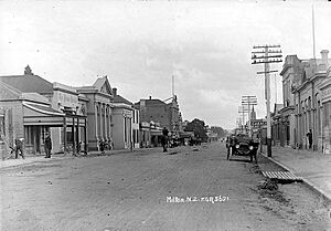
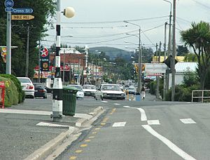
Today, Milton is the second largest town in South Otago, after Balclutha. The town is mostly built along the main highway, State Highway 1. There's also a part of town called Helensbrook, which is north of the river.
The old town of Fairfax is now a small village called Tokoiti. Tokoiti means "small poles" in the Māori language. State Highway 1, also known as Union Street, is the main road in Milton. Five main streets run next to Union Street: Elderlee, Ajax, Spenser, Johnson, and Chaucer Streets. Other roads connect these streets, forming a mostly regular grid pattern. Tokoiti is about one kilometre southeast of Milton.
Milton's main purpose today is to serve the farms around it. Forestry (growing trees for wood) is also becoming more important. Milton is also home to Calder Stewart, one of New Zealand's biggest construction companies.
The farming area of Milburn, two kilometres north of Milton, was chosen for a new prison. It opened in 2007 and can hold 485 prisoners. Its official name is the Otago Corrections Facility. But people quickly gave it the nickname "The Milton Hilton".
"The Kink" in Union Street
In Milton, there's a strange thing about the main street, Union Street. It's straight for several kilometres as it crosses the Tokomairaro Plain and goes through the town. But in the northern part of Milton, it has a sudden bend or "kink" in it. If you're heading north on the main street, the road suddenly shifts a whole road-width to the west.
People disagree about why this "kink" is there. A common idea, but not the official one, is that two surveyors laid out the road. One started from the north, and the other from the south. Each surveyor marked the road slightly to the right of their survey line.
Another popular belief is that the road changed direction to protect a large tree that used to stand where the kink is. However, it's unclear why a single tree would be protected in an area being developed for milling. Also, this idea doesn't explain why the road didn't go back to its original straight line after passing the tree.
A story about "The Kink" was published by Stuff on May 6, 2021.
Climate in Milton
| Climate data for Milton (1971–2000 normals, extremes 1964–1985) | |||||||||||||
|---|---|---|---|---|---|---|---|---|---|---|---|---|---|
| Month | Jan | Feb | Mar | Apr | May | Jun | Jul | Aug | Sep | Oct | Nov | Dec | Year |
| Record high °C (°F) | 32.0 (89.6) |
33.6 (92.5) |
30.0 (86.0) |
26.8 (80.2) |
23.2 (73.8) |
17.8 (64.0) |
19.5 (67.1) |
20.5 (68.9) |
24.0 (75.2) |
27.8 (82.0) |
29.5 (85.1) |
29.9 (85.8) |
33.6 (92.5) |
| Mean daily maximum °C (°F) | 20.2 (68.4) |
20.4 (68.7) |
18.5 (65.3) |
15.8 (60.4) |
12.3 (54.1) |
9.6 (49.3) |
9.2 (48.6) |
11.0 (51.8) |
13.5 (56.3) |
15.5 (59.9) |
17.2 (63.0) |
19.0 (66.2) |
15.2 (59.3) |
| Daily mean °C (°F) | 14.8 (58.6) |
14.8 (58.6) |
13.0 (55.4) |
10.4 (50.7) |
7.6 (45.7) |
5.2 (41.4) |
4.8 (40.6) |
6.2 (43.2) |
8.4 (47.1) |
10.4 (50.7) |
11.9 (53.4) |
13.8 (56.8) |
10.1 (50.2) |
| Mean daily minimum °C (°F) | 9.4 (48.9) |
9.2 (48.6) |
7.5 (45.5) |
5.1 (41.2) |
2.9 (37.2) |
0.9 (33.6) |
0.3 (32.5) |
1.3 (34.3) |
3.3 (37.9) |
5.3 (41.5) |
6.6 (43.9) |
8.6 (47.5) |
5.0 (41.1) |
| Record low °C (°F) | 0.8 (33.4) |
−0.4 (31.3) |
−2.1 (28.2) |
−3.1 (26.4) |
−7.0 (19.4) |
−8.1 (17.4) |
−7.4 (18.7) |
−6.7 (19.9) |
−6.1 (21.0) |
−2.9 (26.8) |
−2.0 (28.4) |
−1.3 (29.7) |
−8.1 (17.4) |
| Average rainfall mm (inches) | 71 (2.8) |
52 (2.0) |
62 (2.4) |
63 (2.5) |
78 (3.1) |
73 (2.9) |
59 (2.3) |
47 (1.9) |
47 (1.9) |
58 (2.3) |
65 (2.6) |
72 (2.8) |
747 (29.5) |
| Source: NIWA (rainfall 1951–1980) | |||||||||||||
Schools in Milton
Milton has several schools for different age groups.
Primary Schools
- Milton Primary School is a state school for both boys and girls. It teaches students from Year 1 to Year 6. It has a roll of 93 students as of February 2024.
- Tokoiti School is also a state school for boys and girls. It teaches students from Year 1 to Year 6. It has a roll of 29 students.
- St Mary's School is a state-integrated Catholic school. It's for boys and girls in Year 1 to Year 6. It has a roll of 55 students.
Secondary Schools
- Tokomairiro High School is a state secondary school for both boys and girls. It teaches students from Year 7 to Year 13. It has a roll of 203 students.
Famous People from Milton
Many notable people have connections to Milton:
- Ken Bloxham – a famous All Black rugby player
- Richard Hayes – a pilot
- Samantha Hayes – a TV news journalist
- Thomas Joseph King – an Army Officer
- Tony Kreft – an All Black rugby player
- Frank Oliver – an All Black rugby player
- Richard Pearse – an aviation pioneer who lived in Milton for a while
- Martin Phillipps – a musician who spent some of his childhood in Milton
- Edward Stewart – an All Black rugby player
- Daryl Tuffey – a test cricketer
- Arthur Anderson Martin – a surgeon
 | Valerie Thomas |
 | Frederick McKinley Jones |
 | George Edward Alcorn Jr. |
 | Thomas Mensah |


