
Gore, New Zealand facts for kids
Quick facts for kids
Gore
Maruawai (Māori)
|
|
|---|---|
|
Town
|
|

Sculpture of the brown trout at the northern entrance to Gore
|
|
| Country | New Zealand |
| Region | Southland region |
| Territorial authorities of New Zealand | Gore District |
| Ward | Gore Ward |
| Electorates |
|
| Area | |
| • Total | 13.76 km2 (5.31 sq mi) |
| Population
(June 2023)
|
|
| • Total | 8,240 |
| • Density | 598.8/km2 (1,551.0/sq mi) |
| Time zone | UTC+12 (NZST) |
| • Summer (DST) | UTC+13 (NZDT) |
| Postcode(s) |
9710
|
| Area code(s) | 03 |
| Local iwi | Ngāi Tahu |
| Website | www.GoreDC.govt.nz |
Gore (Māori: Maruawai) is a town in the Southland area of New Zealand's South Island. It is known for its country music and farming. The town has a population of about 8,240 people.
Contents
About Gore, New Zealand
Gore is on State Highway 1. It is about 64 kilometres northeast of Invercargill and 70 kilometres west of Balclutha. Gore is the second largest town in the Southland region.
The Mataura River divides the town into two parts: Gore and East Gore. Most of the town is on the western side of the river. Gore is also near the Hokonui Hills, and many farms are in the hills around the town.
A railway line from Christchurch to Invercargill goes through Gore. Passenger trains stopped running in 2002. Gore used to be a busy railway hub. Other railway lines, like the Waimea Plains Railway, also connected to Gore.
History of Gore
Before Europeans arrived, Māori travelers used routes that passed through or near where Gore is today. The closest Māori settlement was Tuturau, near modern Mataura. In 1836, southern Māori successfully defended their land from a northern raid. This made the area safe for Europeans to buy land and settle. By the mid-1850s, many large sheep farms were set up nearby.
How Gore Got Its Name
Crossing the Mataura River used to involve a long walk through shallow water. Because of this, the area was called "the Long Ford." In 1862, some town areas were marked out on the west bank of the river. The town was then named Gore, in honor of Sir Thomas Gore Browne, an early Governor of New Zealand. One of the first buildings was Long Ford House, a place for travelers to stay.
A village called Gordon grew on the other side of the Mataura River. It was named after Governor Sir Arthur Gordon. By 1864, a road from Balclutha through Gore to Invercargill was built. This allowed regular coach services to run between Invercargill and Dunedin.
Growth and Development
By 1877, Gore had enough businesses for the Bank of New Zealand to open a branch. Other banks soon followed.
.jpg)
A railway line between Invercargill and Gore opened on August 30, 1875. By 1879, the railway reached Balclutha, connecting Gore to Dunedin. Another private railway line, the Waimea Plains railway, opened in 1880, connecting Gore to Lumsden. These railways helped Gore grow into an important center.
Newspapers also started in Gore. The Ensign began publishing in 1879, and the Standard followed in 1887.
Gore Becomes a Borough
In 1885, Gore officially became a borough, which is a type of town. In 1890, Gordon (now called East Gore) joined with Gore. The town even earned the nickname "Chicago of the South."
By 1905, Gore's population had grown to 2,354 people. In 1894, Gore became the third town in New Zealand to have a public electricity supply.
After the Second World War until 1976, Gore was very successful. This was because farm product prices were high. The town's population grew from 5,000 in 1945 to 9,000 in 1976. By the late 1960s, Gore was known for having the highest retail sales per person in New Zealand.
Recent Times
After 1976, the farming industry faced challenges, and Gore's population decreased. Some businesses closed, including the town's cereal mill, which had been processing grains since 1877.
However, since 2000, Gore has seen new growth. Many farms in the area have changed to dairy farms, thanks to good prices for dairy products. This has led to low unemployment in the town.
Marae in Gore
O Te Ika Rama Marae is a special meeting place for the Hokonui Rūnanga branch of Ngāi Tahu, a Māori tribe. It includes the O Te Ika Rama wharenui (meeting house). In 2020, the government provided funds to improve the marae, creating jobs for the community.
Climate in Gore
Gore has an oceanic climate. This means it has mild temperatures and rainfall throughout the year.
| Climate data for Gore (1991–2020 normals, extremes 1907–present) | |||||||||||||
|---|---|---|---|---|---|---|---|---|---|---|---|---|---|
| Month | Jan | Feb | Mar | Apr | May | Jun | Jul | Aug | Sep | Oct | Nov | Dec | Year |
| Record high °C (°F) | 35.0 (95.0) |
34.1 (93.4) |
32.2 (90.0) |
27.8 (82.0) |
23.3 (73.9) |
20.0 (68.0) |
18.3 (64.9) |
23.9 (75.0) |
24.4 (75.9) |
27.2 (81.0) |
30.0 (86.0) |
34.7 (94.5) |
35.0 (95.0) |
| Mean daily maximum °C (°F) | 19.4 (66.9) |
19.2 (66.6) |
17.5 (63.5) |
14.7 (58.5) |
11.9 (53.4) |
9.1 (48.4) |
8.6 (47.5) |
10.4 (50.7) |
12.8 (55.0) |
14.4 (57.9) |
16.0 (60.8) |
18.2 (64.8) |
14.4 (57.8) |
| Daily mean °C (°F) | 14.5 (58.1) |
14.3 (57.7) |
12.7 (54.9) |
10.3 (50.5) |
7.9 (46.2) |
5.5 (41.9) |
4.8 (40.6) |
6.4 (43.5) |
8.4 (47.1) |
9.9 (49.8) |
11.3 (52.3) |
13.4 (56.1) |
10.0 (49.9) |
| Mean daily minimum °C (°F) | 9.6 (49.3) |
9.4 (48.9) |
7.8 (46.0) |
5.8 (42.4) |
3.9 (39.0) |
1.9 (35.4) |
1.0 (33.8) |
2.4 (36.3) |
4.0 (39.2) |
5.4 (41.7) |
6.7 (44.1) |
8.6 (47.5) |
5.5 (42.0) |
| Record low °C (°F) | −1.1 (30.0) |
−1.1 (30.0) |
−1.7 (28.9) |
−4.2 (24.4) |
−6.1 (21.0) |
−7.8 (18.0) |
−8.3 (17.1) |
−8.9 (16.0) |
−5.6 (21.9) |
−3.4 (25.9) |
−1.7 (28.9) |
−1.7 (28.9) |
−8.9 (16.0) |
| Average rainfall mm (inches) | 92.7 (3.65) |
77.9 (3.07) |
73.0 (2.87) |
70.8 (2.79) |
75.9 (2.99) |
78.2 (3.08) |
59.1 (2.33) |
60.0 (2.36) |
65.7 (2.59) |
88.4 (3.48) |
89.2 (3.51) |
87.8 (3.46) |
918.7 (36.18) |
| Source: NIWA | |||||||||||||
Media and Entertainment
Gore has its own local radio stations. Hokonui broadcasts country music and local news. Cave FM is a smaller, locally owned station that also broadcasts in Gore and online.
Education in Gore
Gore has schools for all ages, from primary to high school. All schools mentioned below are for both boys and girls.
High Schools
- Gore High School is the biggest school in Gore. It teaches students from Year 9 to Year 13. It opened in 1908 and has about students.
- St Peter's College is a Catholic school for students from Year 7 to Year 13. It has about 387 students. It started as a private school in 1969 and became a state-integrated school in 1982.
Intermediate School
- Longford Intermediate School is for students in Year 7 and Year 8. It has about students and opened in 1972.
Primary Schools
There are four primary schools in Gore, for students from Year 1 to Year 6.
- East Gore School has about 86 students. It opened in 1886 as Gordon School and changed its name in 1907.
- Gore Main School has about 177 students. It first opened in 1878. The school buildings were rebuilt in 1896, 1922, and again in 1984 after fires.
- St Marys School is a Catholic school with about 185 students. It opened in 1890.
- West Gore School has about 144 students. It opened in 1953.
All student numbers are from February 2024. .
Culture and Arts
Gore is famous for its connection to Country and Western music. The annual New Zealand country music awards have been held in the town for 36 years. Gore is a sister city with Tamworth, New South Wales, which is known as the "Country Music Capital of Australia".
Gore is also becoming known for its visual arts. The town's Eastern Southland Art Gallery has a great collection of art. This includes a large collection of ethnological art (art from different cultures) and modern New Zealand art, with pieces by famous artist Ralph Hotere.
Landmarks and Features

The Flemings "Creamoata Mill" is a well-known building in Gore. The Flemings "Creamoata" brand of porridge was once called the "National Breakfast." The mill was considered one of the most modern cereal mills in the Southern Hemisphere. Production moved to Australia in 2001, and Creamoata was stopped in 2008. The building's famous "Sgt Dan" sign remains because a company called "Sgt Dan Stockfoods Ltd" bought the rights to it. The building is a Category I historic place.
The old East Gore Presbyterian Church is one of only two wooden Gothic churches designed by the famous architect R.A. Lawson. Built in 1880, it is a Category 2 historic place. It is no longer a church and is being turned into an art center. It will have a studio and a flat for visiting artists. This flat even has bedroom furniture from the Royal Suite used by Queen Elizabeth II during her visit to Southland in 1954.
The Hokonui Moonshine Museum celebrates Gore's history of making illegal whiskey. This "moonshine" was made in the Hokonui Hills until the 1930s.
The St James Theatre on Irk Street is a theatre and cinema. It has a main hall that seats 450 people and a smaller room for 78. In 2021, the theatre announced it might close if it couldn't raise money for repairs and safety upgrades.
Notable People from Gore
Many well-known people have come from Gore:
- Ronald Bannerman, a brave pilot during World War I. Bannerman Park in Gore is named after him.
- Jimmy Cowan, an international rugby player.
- James Hargest, a politician and military leader.
- Amanda Hooper (Christie), an international women's hockey player.
- Luke Hurley, a musician.
- Hadyn Jones, a television journalist.
- Roy Kerr, a mathematical physicist.
- Justin Marshall, an international rugby player.
- Shona McFarlane, an artist and broadcaster.
- Hugh McIntyre, a farmer and business leader.
- Brian McKechnie, an international cricket and rugby player.
- Chris McLennan, a travel photographer.
- Mike Puru, a radio host.
- Geoff Rabone, an international cricketer.
- Eric Roy, a politician.
- Jenny Shipley, a former Prime Minister of New Zealand.
- Barry Soper, a political journalist.
- Stu Wilson, an international rugby player.
- Ethan de Groot, an international rugby player.
Images for kids
-
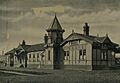
Gore Railway Station around 1887–1915
-
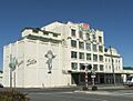
Fleming's Rolled Oats factory, a major landmark in central Gore.
See also
 In Spanish: Gore (Nueva Zelanda) para niños
