
Southland Region facts for kids
Quick facts for kids
Southland
Māori: Murihiku
|
|
|---|---|
|
Region
|
|
| Southland Region | |
|
|
|

Southland within the South Island, New Zealand
|
|
| Country | New Zealand |
| Island | South Island |
| Established |
|
| Seat | Invercargill |
| Territorial authorities | |
| Government | |
| • Body | Southland Regional Council |
| Area | |
| • Land | 31,218.27 km2 (12,053.44 sq mi) |
| Population
(June 2023)
|
|
| • Region | 103,900 |
| GDP | |
| • Total | NZ$ 7.396 billion (2021) |
| • Per capita | NZ$ 72,223 (2021) |
| Time zone | UTC+12 (NZST) |
| • Summer (DST) | UTC+13 (NZDT) |
| HDI (2017) | 0.906 very high · 10th |
| Website | https://www.es.govt.nz/ |

.jpg)

.JPG)
Southland (called Māori: Murihiku in Māori, meaning "the last joint of the tail") is New Zealand's southernmost region. It covers the southwestern part of the South Island and includes Stewart Island. Southland shares borders with the Otago Region to the north and east. It also borders the West Coast Region in the far northwest.
Southland is a large area, covering over 3.1 million hectares. It has a long coastline of 3,613 km. As of June 2023, about 103,900 people live in Southland. This makes it the eleventh-most-populated region in New Zealand. It is also the second-most spread out, meaning not many people live close together. About half of the region's population lives in Invercargill, which is Southland's only city.
The first people to live in Southland were Māori from the Waitaha tribe (iwi). Later, the Kāti Māmoe and Kāi Tahu tribes arrived. Early European visitors were sealers and whalers. By the 1830s, Kāi Tahu had a successful business supplying whaling ships. They also helped whalers and settlers.
Later in the 1800s, these industries became less important. More immigrants, mostly Scottish settlers, moved further inland. Southland still has a strong cultural identity. This includes its own special way of speaking English, called the Southland burr. It also has strong influences from its Māori and Scottish history.
Southland stretches from Fiordland in the west to the Catlins in the east, past the Mataura River. It is home to New Zealand's highest waterfall, the Browne Falls. It also has the country's deepest lake, Lake Hauroko. Fiordland has many mountains, fiords, and glacial lakes. These were carved out by glaciations (ice ages) between 75,000 and 15,000 years ago.
The coast of Southland has many fiords and sea inlets. These stretch from Milford Sound in the north to Preservation Inlet in the south. Further north and east in Fiordland are the Darran and Eyre Mountains. These mountains are part of a large rock formation that goes into Central Otago. Southland has many natural resources. These include large amounts of forestry, coal, petroleum, and natural gas.
Contents
Southland's Past: A Journey Through Time
The first people to live in Murihiku (Southland) were Māori from the Waitaha tribe. Later, the Kāti Māmoe and Kāi Tahu tribes arrived. The Waitaha people traveled on a special canoe called the Uruao waka. Their captain, Rakaihautū, named places and carved out lakes in the area. The Takitimu Mountains were formed from the overturned Kāi Tahu waka called Tākitimu. Māori families created networks of food gathering spots. They traveled with the seasons to support their homes along the coast and inland.
Early European Contact
The coastline was a place where Māori and Europeans first met. These Europeans included sealers, whalers, and missionaries. One famous missionary was Wohlers at Ruapuke Island. Contact started as early as 1813. By the 1830s, the Kāi Tahu tribe had a busy business. They supplied whaling ships and helped whalers and settlers. Māori and settlers began to live together.
Throughout the 1800s, local Māori traveled often for trade. A "Māori house" was built in 1881. It was for Māori who traveled from Ruapuke and Stewart Island to Bluff to sell their goods.
The Treaty of Waitangi
On June 10, 1840, Tūhawaiki signed the Treaty of Waitangi. He was a very important chief of the Kāi Tahu tribe. He signed it on a ship called HMS Herald at Ruapuke. Tūhawaiki knew that this treaty might not keep his land safe. He had said he would only sign it if the Europeans signed a treaty he had written first.
In 1853, Walter Mantell bought Murihiku from the local Māori tribes. He claimed the land for European settlement. Part of the deal was that schools and hospitals would be built near each Kāi Tahu village. However, this promise was not kept. The borders of the land sold were also not clear. The Kāi Tahu always said that Fiordland was not meant to be part of this sale.
Scottish Settlers Arrive
Over many years, many Scottish settlers moved to what is now Southland and Otago. They came to New Zealand because of money problems in Scotland. Also, there was a split between two churches there.
In 1852, James Menzies became the first leader of the Southland area. At that time, Southland was still part of the larger Otago region. Menzies wanted Southland to be separate. Because of his influence, Southland Province broke away from Otago in 1861. This happened after political arguments became worse.
However, Southland had money problems. It had to rejoin Otago in 1870. The province system was completely stopped on November 1, 1876.
Growth of Dairy Farming
In the 1880s, Southland started to export butter and cheese. This helped dairy farming grow in the region. The first dairy factory in New Zealand was built at Edendale in 1882. Much of these products were sent to the United Kingdom.
Today, Edendale has the world's largest raw milk-processing plant. Southland's economy now relies on farming, tourism, fishing, forestry, coal, and hydropower.
The Southland Region and the Southland Regional Council were created in 1989. This was part of changes to local government in New Zealand.
How Southland is Governed

Southland is divided into two areas for the parliament. These are called electorates. The large rural electorate of Southland includes some of the nearby Otago Region. It is currently represented by Joseph Mooney. The Invercargill area is represented by Penny Simmonds. Both of these politicians are from the National Party.
Southland is also part of a special Māori electorate called Te Tai Tonga. This area covers the entire South Island and nearby islands. It is currently represented by Rino Tirikatene from the Labour Party.
National Parks in Southland
Southland is home to two amazing national parks: Fiordland National Park and Rakiura National Park. Fiordland National Park is New Zealand's largest national park. It covers 7,860 square kilometers. Southland also includes Stewart Island. About 85% of Stewart Island is covered by Rakiura National Park. The Department of Conservation manages both of these parks.
Southland's Landscape and Features

Southland stretches from Fiordland in the west to Catlins in the east, past the Mataura River. To the north, the Darran and Eyre Mountains frame Southland. Further south is Stewart Island, separated from the mainland by the Foveaux Strait.
Southland has New Zealand's highest waterfall, the Browne Falls. Lake Hauroko is the deepest lake in the country. The highest mountain in Southland is Mount Tūtoko. This peak is part of the Darran mountains. The largest lake in Southland is Lake Te Anau, followed by Lake Manapouri. Both are inside Fiordland National Park. This park was created on February 20, 1905. It is the largest national park in New Zealand. Most of Fiordland has no people living there permanently.
Fiordland's landscape has many mountains, fjords, and glacial lakes. These were shaped by ice ages between 75,000 and 15,000 years ago. The coast has many fiords and sea inlets. They stretch from Milford Sound in the north to Preservation Inlet in the south. Further north and east in Fiordland are the Darran and Eyre Mountains. These are part of a large rock area that extends into Central Otago.
East of the Waiau River, you'll find the Southland Plains. These plains have some of New Zealand's most fertile farmland. Southland's two main towns, Invercargill and Gore, are on these plains. The plains go from the Waiau River in the west to the Mataura River in the east. The southern part of these plains has many wetlands and swamps. This includes the Awarua Plains near Bluff.
In the far southeast of Southland, there are the rough hills of The Catlins. This area is split between Southland and the nearby Otago region. The largest town there, Owaka, is in Otago. The Catlins hills are part of a big geological fold system. This system, called the Southland Syncline, extends northwest from the coast. It includes the Hokonui Hills above Gore.
Off the coast of Southland is the Great South Basin. This huge area covers over 500,000 km2. That's 1.5 times the size of New Zealand's land! It is one of the country's largest untouched offshore areas for oil and gas.
Southland's Climate: Weather Patterns
Southland's weather is cooler than other parts of New Zealand. This is because it is further from the Equator. However, the weather can be divided into three types:
- The coastal areas have a mild ocean climate.
- The inland areas have a semi-continental climate.
- Fiordland to the west has a wetter mountain climate.
Because Southland is closer to the South Pole, you can often see the Aurora Australis or "Southern Lights" here.
Coastal Weather
The coastal areas have mild summers and cool winters. The average daily temperature is about 5.2 °C in July and 14.9 °C in January. Rainfall is between 900 mm and 1300 mm each year. Rain falls more often in coastal areas, and rainbows are a common sight. Summers are mild, but sudden heavy rain and cold snaps can happen. For example, on January 7, 2010, Invercargill had a hail storm. Temperatures quickly dropped from 15 °C to 8 °C that afternoon. Sometimes, temperatures go above 25 °C. The highest temperature recorded in Invercargill was 33.8 °C in 1948. In Winton, it reached 35.0 °C in 2018.
Winters are colder and harsher than in other regions. The average highest temperature in July is 9.5 °C. Southland's lowest recorded temperature was −18 °C in July 1946. Snow and frost often happen in inland areas. But they are less common and not as extreme in coastal areas. The ocean helps keep coastal temperatures milder. The long, cool, and wet conditions are caused by a low-pressure area southeast of the country.
Fiordland's Mountain Climate
Fiordland has a wet mountain climate. But conditions change depending on how high up you are and how exposed the area is. Rainfall is the highest in the country, between 6,500 and 7,500 mm each year. The coastal parts of Fiordland have a small temperature range. Rainfall increases at higher altitudes. The wet climate is influenced by low-pressure systems that move across the country and into Fiordland.
Southland's People and Places
Southland Region covers about 31,218 square kilometers. It has an estimated population of about 103,900 people as of June 2023. This is about 2.0% of New Zealand's total population. It is the country's second-most spread out region. This means there are about 3.3 people per square kilometer.
Southland had a population of 100,143 in the 2023 New Zealand census. This was an increase of 2,676 people (2.7%) since the 2018 census. It was an increase of 6,801 people (7.3%) since the 2013 census. There were 46,761 homes. The average age was 40.4 years. There were 18,921 people (18.9%) under 15 years old. There were 17,211 (17.2%) aged 15 to 29. Also, 45,495 (45.4%) were aged 30 to 64, and 18,516 (18.5%) were 65 or older.
The different ethnic groups were:
- 84.1% European/Pākehā
- 16.8% Māori
- 3.3% Pasifika
- 7.1% Asian
- 1.0% Middle Eastern, Latin American, and African New Zealanders
- 1.5% other ethnicities.
People can identify with more than one ethnicity.
In the 2018 census, 12.2% of people were born overseas. This is lower than the national average of 27.1%. About 50.7% of people said they had no religion. 38.5% were Christian. Other religions included Hindu (0.6%), Muslim (0.3%), and Buddhist (0.4%).
For those aged 15 and older, 14.1% had a university degree or higher. 25.3% had no formal qualifications. The average income was $32,100. About 14.0% of people earned over $70,000. For those 15 and older, 52.5% worked full-time. 15.6% worked part-time, and 3.1% were unemployed.
Many people who moved to Southland in the 1800s came from Scotland and Ireland. Māori people mostly live around the port of Bluff. In the 1940s, the growth of meat processing plants brought more Māori from the North Island to the region for a short time.
In the 2000s, the number of people of Asian origin in Southland grew. This was because dairy farms hired many workers, often from the Philippines. In 2013, people of Asian origin made up 3.2% of Southland's total population.
Southland has one of New Zealand's strongest regional identities. It is the only part of New Zealand with a special regional accent. This accent is known for a rolling 'r' sound. A local food specialty is cheese rolls. Swedes are also a popular vegetable, cooked like pumpkin or kumara (sweet potato) elsewhere. For many years, a TV channel called Southland TV (later Cue TV) showed content about Southland. The strong identity might be because a high number of people in the region were born in New Zealand. In 2013, 85% were New Zealand-born, compared to 70% for New Zealand as a whole.
Cities and Towns in Southland
Invercargill is the main city and the center of local government. It has a population of about 51,700 people. This means it makes up half of Southland's total population. Six other towns have populations over 1,000:
Most of Southland's population lives on the eastern Southland Plains. Fiordland, the western part of the region, has almost no permanent human settlements.
| Name | Population (June 2023) |
% of region |
|---|---|---|
| Invercargill | 51,000 | 49.1% |
| Gore | 8,240 | 7.9% |
| Winton | 2,460 | 2.4% |
| Te Anau | 3,060 | 2.9% |
| Bluff | 1,840 | 1.8% |
| Mataura | 1,740 | 1.7% |
| Riverton | 1,640 | 1.6% |
Southland's Economy: How People Make a Living
.jpg)
Southland's economy was estimated to be worth NZ$6.36 billion in March 2019. This was 2.1% of New Zealand's total economy. The average income per person was about $63,084. In March 2018, primary industries (like farming) made up 22.4% of the region's economy. Industries that make goods contributed 25.2%. Service industries (like tourism) contributed 43.7%.
The region's economy is based on several key areas. These include farming, tourism, fishing, forestry, and energy sources like coal and hydropower.
Farming and Dairy
The farming industry includes both sheep and dairy farming. These are a big part of Southland's income and exports. Much of this farming happens on the Southland Plains. Since the 1950s and 1960s, farming has also expanded into more distant western areas. Southland also has the world's largest raw milk-processing plant. It is located in the town of Edendale and is owned by Fonterra. In the 2019-20 season, Southland had 591,600 milking cows. This was 12.0% of all cows in the country. These cows produced 247,230 tonnes of milk solids. This was worth $1,780 million.
Energy and Tourism
Other important industries in Southland are coal and hydroelectric power. Eastern Southland has a lot of lignite coal. This is considered New Zealand's biggest fossil fuel energy source. A company called Solid Energy used to operate open-pit lignite mines at Newvale and Ohai.
Southland is home to New Zealand's largest hydroelectric power station. It is located at Manapouri and is owned by Meridian Energy. This station powers the Tiwai Point Aluminium Smelter. The Manapouri project caused a lot of debate among environmental groups. They started the Save Manapouri Campaign because they were worried about rising water levels in nearby lakes.
Tourism is a big part of Southland's economy. Visitors spent NZ$595 million in 2016. Of this, $210 million was spent in the Fiordland area. In July 2007, the New Zealand Government allowed companies to explore for oil and gas in four areas of the Great South Basin. The companies that got permits were ExxonMobil New Zealand, OMV, and Greymouth Petroleum.
Images for kids
-
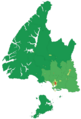
A map showing how many people live in different parts of the Southland Region, based on the 2006 census.
-
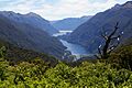
Doubtful Sound is a beautiful fiord in Southland.
-
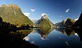
Fiordland National Park is a major tourist attraction in Southland.
See also
 In Spanish: Región de Southland para niños
