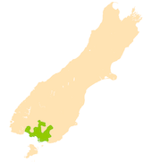
Southland Plains facts for kids
The Southland Plains is a general name for several flat areas of land in the South Island of New Zealand. These plains are separated by the Hokonui Hills in the north. They make up a big part of the Southland Region and include its two main towns: the city of Invercargill and the town of Gore. The Southland Plains are known for having some of New Zealand's most fertile farmland.
Exploring the Southland Plains
The Southland Plains stretch from the Waiau River in the west to the Mataura River in the east. The Mataura River also forms the border with the Otago region.
The plains can be divided into three main parts:
- The Southland Plain (the main part)
- The Waimea Plains
- The lower Waiau Plain
The Southland Plain
The Southland Plain and the Waimea Plains are separated by the Hokonui Hills, which are west of Gore. The Southland Plain is located north of Invercargill. It was formed by several large rivers, including the Aparima, the Oreti, and the Makarewa. This plain reaches inland for more than 45 kilometers from the coast of the Foveaux Strait. It covers an area of almost 1,500 square kilometers.
The Waimea Plains
To the northeast of Invercargill, you'll find the Waimea Plains. These plains are part of the Mataura River area and its smaller river, the Waimea River. They stretch inland all the way to the town of Gore.
At their southern end, the Waimea Plains become the Awarua Plain. This is a large area of marshy, wet land. It stretches from near Bluff to the base of the Catlins in the far east. Together, the lowlands around the Awarua Plain and the Mataura River cover another 2,000 square kilometers.
The Lower Waiau Plain
To the west, there is a smaller area called the lower Waiau Plain. This plain is located around the mouth of the Waiau River. It is found between the Longwood Range to the east and the beautiful Fiordland area to the west.
 | Aurelia Browder |
 | Nannie Helen Burroughs |
 | Michelle Alexander |


