
The Catlins facts for kids
|
|
|
 |
|
|
|
|
| Location | |
|---|---|
| Country: | New Zealand |
| Island: | South Island |
| Statistics | |
| Population: | approximately 1,200 (2001) |
| Area: | 1,900 km2 (730 sq mi) |
| Location | |
| Coordinates: | 46°30′S 169°30′E / 46.500°S 169.500°E |
| Administration | |
| Regions: | Otago and Southland |
| Districts: | Clutha District and Southland District |
| Main towns and settlements: | Owaka, Papatowai, Waikawa, Tokanui, Kaka Point, Fortrose |
| Parliamentary electorate: | Clutha-Southland |
The Catlins, also known as The Catlins Coast, is a special area in the southeastern part of New Zealand's South Island. It sits between the towns of Balclutha and Invercargill. This region crosses the border between the Otago and Southland areas. It is home to Slope Point, the southernmost tip of the South Island.
This rugged and quiet place is famous for its beautiful coastlines and thick temperate rainforests. These forests are home to many rare birds, like the yellow-eyed penguin. The coast also attracts lots of sea animals, such as New Zealand fur seals and Hooker's sea lions.
The Catlins has a cool, ocean-influenced climate. Its open location means it often has wild weather and big ocean waves. These waves are a big draw for big-wave surfers. Sadly, the strong waves have also caused many shipwrecks over the years.
People have lived in the Catlins since about 1350 AD. Before Europeans arrived, Māori groups lived here, often near river mouths. Later, whalers and sealers visited the area. From the mid-1800s until the 1930s, cutting down trees for timber was a major industry.
Today, tourism is growing in the Catlins. The main jobs are still dairy farming and fishing. The population has dropped since the early 1900s. About 1,200 people live here now, many in the town of Owaka. Owaka has the main school for the area, called the Catlins Area School.
Contents
- Exploring the Catlins' Landscape
- Catlins Weather and Climate
- A Look Back: Catlins History
- Wildlife and Plants of the Catlins
- People and Communities
- Catlins Economy and Jobs
- Getting Around the Catlins
- How the Catlins is Governed
- Learning in the Catlins
- Health Services in the Catlins
- Images for kids
- See also
Exploring the Catlins' Landscape
The Catlins covers about 1,900 km2 (730 sq mi) of land. It forms a rough triangle shape, reaching up to 40 km (25 mi) inland. The coastline stretches for about 100 km (60 mi). The Clutha River in the northeast and the Mataura River in the west mark its coastal edges.
Coastal Wonders and High Cliffs

The Catlins coast is very scenic. It has sandy beaches, blowholes, and a petrified forest at Curio Bay. You can also visit the amazing Cathedral Caves when the tide is low. Much of the coast has high cliffs, some up to 200 m (660 ft) tall. The land rises steeply from the sea in many places. This is why many rivers here form beautiful waterfalls as they reach the ocean. A famous example is the Purakaunui Falls.
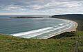
Slope Point is the South Island's southernmost point. It is located near the southwestern part of the Catlins. To its west is Waipapa Point, which many consider the western edge of the Catlins.
Inland Hills and Rivers

Inside the Catlins, several parallel ranges of hills stand out. They are separated by valleys with rivers like the Ōwaka, Catlins, and Tahakopa River. These rivers all flow southeast into the Pacific Ocean. The most well-known hills are often called the Catlins Ranges.
The highest point in the Catlins is Mount Pye, which is 720 m (2,360 ft) high. It is about 25 km (16 mi) north-northeast of Waikawa. Other tall peaks include Mount Rosebery and Catlins Cone. The Catlins also has small lakes, like the pretty Lake Wilkie. Catlins Lake, near Owaka, is actually where the Catlins River meets the tide.
Lighthouses and Ocean Swells
The Catlins coast has always been dangerous for ships. Many shipwrecks have happened on its rocky points. Two lighthouses help guide ships safely. The Nugget Point Lighthouse stands 76 m (249 ft) above the water. It has been shining its light since 1870. The Waipapa Point light was built in 1884. It was the last wooden lighthouse in New Zealand. Both lighthouses are now automatic.
The Catlins coast gets some of New Zealand's biggest ocean swells, often over 5 m (16 ft) high. This area is becoming famous for big wave surfing. Surfing competitions and amazing rides have brought attention to the sport here.
Catlins Weather and Climate
The Catlins has a cool maritime temperate climate. It is a bit cooler than other parts of the South Island. The Pacific Ocean greatly affects its weather. Winds can be very strong, especially along the open coast. Many storms in the South Island form to the south or southwest. This means the Catlins often gets the full force of these storms.
The Catlins, especially its central and southern areas, gets a lot more rain than most of the South Island's east coast. Heavy rain is not common, but light drizzle happens often. The region has about 150 rainy days each year. Rain is spread fairly evenly throughout the year. The average yearly rainfall is about 1,300 mm (51 in).
On sunny days, it can be warm. Temperatures can reach over 30 °C (86 °F) in mid-summer (January/February). A more common summer high is 18–20 °C (64–68 °F). Snow is rare, even on the peaks in winter. However, frost is common from June to September. Typical winter high temperatures are 10–13 °C (50–55 °F).
A Look Back: Catlins History
The first people to live in the Catlins were Māori from the Kāti Māmoe, Waitaha, and Kāi Tahu tribes. They later joined together to become the Kāi Tahu tribe. Evidence shows people lived here around 1350 AD. They were semi-nomadic, moving around to find food. They often lived near river mouths. Māori legends say that wild giants called Maeroero lived in the Catlins forests.
The Catlins may have been one of the last places to hunt the giant flightless bird, the moa. The forest timber was also perfect for building canoes. The name of the town Owaka means "Place of the canoe." There were no large Māori villages (pa) in the Catlins. However, there were many hunting camps, especially at Papatowai.
Early European Visitors and Settlements

Europeans first saw the area in 1770. This was when James Cook's ship Endeavour sailed along the coast. Sealers and whalers started the first European settlements in the early 1800s. Hunting sea animals was the main European business in New Zealand then. A whaling station was set up on the Tautuku Peninsula in 1839.
The Catlins gets its name from the Catlins River. The river was named after whaling captain Edward Cattlin. He bought a large area of land along the river in 1840. He bought it from the Kāi Tahu chief Hone Tūhawaiki.
Timber Industry and Shipwrecks

In the mid-1800s, the Catlins became a big timber-producing area. It supplied wood to the growing city of Dunedin. The timber was shipped from ports like Waikawa and Fortrose. Many shipwrecks happened along the dangerous coastline during this time.
One of New Zealand's worst shipping disasters happened here. The passenger-steamer Tararua sank off Waipapa Point in 1881. Only 20 of the 151 people on board survived. Another famous shipwreck was the Surat in 1874. This ship hit rocks and then reached the mouth of the Catlins River. Its 271 immigrants had to leave the ship. A beach there is now called Surat Bay.
After a dip in the 1890s, logging grew again. This was because the railway was extended, making new areas reachable. Logging slowed down in the mid-1900s. The land where trees were cut down became farms. Sheep and dairy farming are still very important to the Catlins' economy. Much of the remaining forest is now protected as part of the Catlins Conservation Park.
Wildlife and Plants of the Catlins
Amazing Wildlife

The Catlins coast is often visited by New Zealand fur seals and Hooker's sea lions. Sometimes, even southern elephant seals can be seen. Several types of penguins also nest along the coast. The rare yellow-eyed penguin (hoiho) is one of them. Other seabirds like mollymawks and Australasian gannets live here too.
River mouths are home to herons, stilts, and oystercatchers. In the forests, you might spot endangered birds like the yellowhead (mohua) and kakariki (New Zealand parakeet). Other birds include the tui, fantail (piwakawaka), and kereru (New Zealand pigeon).
One of New Zealand's only two native land mammals, the long-tailed bat, lives in these forests. Several types of lizards are also found here. Hector's dolphins are often seen near the Catlins coast, especially at Porpoise Bay. This area is part of the Catlins Coast Marine Mammal Sanctuary. During winter, you might even see migrating southern right whales and humpback whales.
Unique Plants and Forests

The Catlins has thick temperate rainforests. These forests are mostly made up of podocarps. This is the largest area of native forest left on the South Island's east coast. Over 500 square kilometres (190 sq mi) of forest is protected in Catlins Conservation Park.
The forest is full of trees like rimu, totara, silver beech, matai, and kahikatea. Some areas have untouched rimu and totara forests. There is also a large area of silver beech forest near the Takahopa River. This is New Zealand's most southerly beech forest. Many native plants grow in the forest undergrowth. These include young lancewoods, orchids, and many different native ferns.
Settlers cleared much of the coastal plants for farms. But in some places, the original coastal plants still survive. These are mainly around cliff edges and some bays. The Catlins coastal daisy is unique to this region. Tussocks, hebes, and flaxes are common. When the southern rātā flowers, the coastal forest canopy turns bright red.
Ancient Geology of the Catlins

The rocks of the Catlins are very old, over 150 million years old. They were formed when thick sediments and volcanoes built up on the edge of the ancient Gondwana supercontinent. The parallel hills of the Catlins are part of the Murihiku terrane.
Curio Bay has the petrified remains of a forest that is 160 million years old. This forest was once a subtropical woodland. It was later covered by the sea. You can see fossilized trees that are related to modern kauri and Norfolk pine trees here.
People and Communities
The Catlins area has very few people. The whole region has only about 1,200 residents. Most of the people live near the Southern Scenic Route. This road used to be a state highway from Balclutha to Invercargill. Many also live in tiny coastal towns.
The biggest town in the Catlins is Owaka, with about 400 people. It is 35 km (22 mi) southwest of Balclutha. Other larger settlements include Kaka Point (population 200), Waikawa, Tokanui, and Fortrose. Most other places are small farming communities or holiday spots. An outdoor education center is located at Tautuku.
Most people in the Catlins are of European background. The average income is lower than in most of New Zealand. However, the unemployment rate is very low.
Catlins Economy and Jobs
In the early 1800s, the Catlins' economy was based on whaling and sealing. Then, in the 1860s, cutting down trees for timber became important. This was because Dunedin was growing fast due to the gold rush. In the 1870s, more timber was shipped from Owaka than any other New Zealand port. The timber industry slowed down in the late 1880s. It picked up again in the 1920s when the railway was extended.
The land cleared of trees became farmland. From the 1880s, more land was used for dairy farming. Sheep and dairy farming are still a big part of the Catlins' income. A farming school, Telford Rural Polytechnic, is located near the Catlins.
Fishing and tourism now make up a lot of the area's economy. The beautiful natural scenery and quietness make the Catlins a popular place for weekend trips. Many people from Dunedin and Invercargill visit. There are many holiday cottages, called cribs, in places like Jack's Bay. Ecotourism is also growing, with many visitors coming from other countries. Tourism added about $2.4 million to the region's economy in 2003.
Getting Around the Catlins
The Southern Scenic Route connects Fiordland and Dunedin through the Catlins. This road runs northeast to southwest. It is an alternative to State Highway 1, which goes around the Catlins. This part of the Southern Scenic Route goes through most of the small towns. It was fully paved in the late 1990s. Owaka, Maclennan, Papatowai, Tokanui, and Fortrose are all on this route.
Other small roads in the area have gravel surfaces. These roads mostly connect the main route to small coastal towns. A railway line, the Catlins River Branch, used to connect the area to the main railway network. It was built from 1879 to 1915. The line closed in 1971 as the timber mills it served declined. Parts of the old railway line are now walking paths. One path goes through a 240 m (790 ft) long tunnel called "Tunnel Hill."
How the Catlins is Governed
The Catlins is part of the Clutha-Southland electorate in the New Zealand Parliament. This means people in the Catlins vote for a Member of Parliament to represent them.
For local government, the Catlins is split between the Clutha and Southland Districts. Most of the Catlins is in the Clutha District, which is based in Balclutha. The Clutha District is part of the Otago Regional Council (ORC). The western part of the Catlins is in the Southland District, based in Invercargill. This district is part of the Southland Regional Council (SRC). These councils help manage local services and resources.
Learning in the Catlins
The Catlins area has four schools. Tahakopa School, Tokanui School, and Romahapa School are all primary schools. Catlins Area School, in Owaka, is a combined primary and secondary school. It is the largest of the four schools. The closest dedicated secondary schools are in Balclutha and Wyndham.
For higher education, Telford Rural Polytechnic is located near the Catlins. Other colleges and universities are in Invercargill and Dunedin. The University of Otago is in Dunedin.
Health Services in the Catlins
Owaka used to have a hospital that opened in 1924. It closed in the 1980s. Now, the building is a youth hostel. Today, Owaka has a medical center and a pharmacy. The Southern District Health Board is in charge of health services in the area.
The closest hospital for most of the Catlins is Clutha Health First in Balclutha. There are also hospitals in Gore, Invercargill, and Dunedin. The hospitals in Invercargill and Dunedin are also teaching hospitals.
Images for kids
-
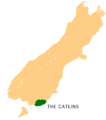
Location of the Catlins in New Zealand's South Island
-
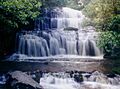
Purakaunui Falls, about 17 km (11 mi) southwest of Owaka
-
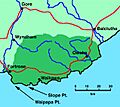
Map of the Catlins
-
The distant Tautuku Peninsula hosted an early whaling station.
-
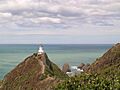
The Nugget Point lighthouse has guided ships since 1870.
-
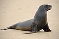
Hooker's sea lions frequent the Catlins coast.
-
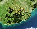
Forested areas show dark green in this satellite picture of the Catlins. The area's parallel strike ridges - part of the Southland Syncline - can clearly be seen running from north-west to south-east in the northern part of this image.
-
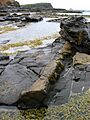
A petrified log at Curio Bay
-
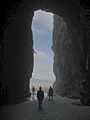
The Cathedral Caves, one of the Catlins' most popular tourist attractions

O then, drama abounds for sure,
and the window to the sea-ward
side of my crib begins rattle-screeching
an order for me to 'Come out! Come out, Sloth!
And witness this!'
'Uh huh', I say.
See also
 In Spanish: The Catlins para niños
