
Slope Point facts for kids

Slope Point is a special place in New Zealand. It's the very southernmost tip of the South Island. Imagine standing at the bottom of the South Island – that's where Slope Point is!
Contents
Where is Slope Point?
Slope Point is located about 24 kilometers (about 15 miles) south of a small town called Waikawa. It's also near a beautiful area known as the Catlins and a bay called Toetoes Bay. If you travel about 70 kilometers (about 43 miles) east from the city of Invercargill, you'll be close to Slope Point. There's even a nearby area named Haldane, which got its name from the first European family who settled there.
What Can You See at Slope Point?
The land around Slope Point is mostly used for sheep farming. You won't find any houses nearby, just wide-open spaces. The coastline here has eroded cliffs that drop down to the sea, showing how the ocean has shaped the land over time.
There's a cool signpost put up by the AA at Slope Point. This sign tells you how far away the Equator (the imaginary line around the middle of the Earth) is, and also how far it is to the South Pole. It's a great spot to think about how big our world is! You'll also see a small solar-powered lighthouse standing on the farmland, helping guide ships.
How Do You Get to Slope Point?
You can't drive right up to Slope Point because there isn't a road that goes all the way. Instead, you need to walk for about 20 minutes. There are some old yellow markers that show you the way.
It's important to know that you can't visit Slope Point during the lambing season. This is when baby lambs are born, usually from September to November. During this time, the farmers need to keep the area quiet and undisturbed for the sheep.
Images for kids
-
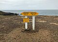
The AA signpost at Slope Point.
-
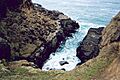
A view to the sea from the area around Slope Point.
.jpg)

See also
 In Spanish: Punta Slope para niños
