Toetoes Bay facts for kids
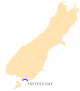
Toetoes Bay is a large bay located on the coast of Southland, New Zealand. It's one of three big bays along the Foveaux Strait, with Te Waewae Bay and Oreti Beach being the others. The bay is about 30 kilometers (20 miles) long.
The Mataura River, which is 240 kilometers long, flows into the sea at Toetoes Bay. Before reaching the sea, it passes through the Toetoes Harbour estuary, which is where the river meets the ocean.
Toetoes Bay is at the southern end of the Awarua Plain. This area is quite swampy and stretches inland for about 15 kilometers (10 miles). The eastern part of the bay is close to Slope Point, which is the southernmost tip of the South Island. It's also near the western end of the Catlins, a beautiful area known for its natural scenery.
What's in the Bay?
At the western end of Toetoes Bay, you'll find Tiwai Point. This peninsula is home to an aluminium smelter and is located near Bluff harbour.
About halfway along the bay, there's a special place called Waituna Lagoon. This lagoon is a unique wetland area. Towards the eastern side of the bay, the Mataura River finally empties its waters into the Foveaux Strait.
How Toetoes Bay Got Its Name
The name "Toetoes Bay" comes from a Māori chief from the 1800s named Toitoi. Long ago, whalers (people who hunted whales) used to call the nearby Waituna Lagoon "Toetoe's Place." Over time, this name was also given to the entire bay, and that's how it got its name!
See also
 In Spanish: Bahía Toetoes para niños
 | Roy Wilkins |
 | John Lewis |
 | Linda Carol Brown |


