
Mataura River facts for kids
Quick facts for kids Mataura River |
|
|---|---|

The Mataura Paper Mill operated on the river until 2000
|
|
 |
|
| Native name | Mataura |
| Country | New Zealand |
| Region | Southland |
| Towns | Athol, Gore, Mataura, Wyndham |
| Physical characteristics | |
| Main source | Mataura Saddle Eyre Mountains 45°18′58″S 168°25′12″E / 45.31611°S 168.42000°E |
| River mouth | Toetoes Bay Pacific Ocean Sea level 46°34′S 168°43′E / 46.567°S 168.717°E |
| Length | 240 km (150 mi) |
| Basin features | |
| Tributaries |
|
The Mataura River is a long and important river in New Zealand. It flows through the Southland Region on the South Island. This river stretches for about 240 kilometers (150 miles).
Contents
About the Mataura River
The Mataura River starts high up in the Eyre Mountains. These mountains are south of a famous lake called Lake Wakatipu. From its start, the river flows southeast, heading towards the town of Gore. After Gore, it turns south and goes through the town of Mataura. Finally, it reaches the Pacific Ocean at a place called Toetoes Bay, on the southern coast of the South Island.
River Features
A lot of the Mataura River's path is "braided." This means the river splits into many smaller, winding channels that look like braids. These channels then join back together.
Wildlife and Fishing
The Mataura River is very well-known for its brown trout. Many people enjoy fishing here. It is also a popular spot for "whitebaiting," which is fishing for tiny, young fish.
The river is also a special place for birds. BirdLife International has called it an Important Bird Area. This is because it is home to breeding groups of the black-billed gull. This type of gull is an endangered species, meaning it is at risk of disappearing forever.
History of the River
For a very long time, until about 18,000 years ago, the Mataura River used to drain Lake Wakatipu. However, glaciers changed the landscape. The old river bed is now blocked by rocks and dirt left behind by glaciers. Today, the Kingston Flyer train line follows part of this ancient river path.
Major Floods
The Mataura River, along with three other main rivers in Southland, caused big floods in January 1984. These rivers are the Waiau, Oreti, and Aparima. The town of Mataura was hit especially hard. Homes and businesses, including a pulp and paper factory, were badly affected by the rising waters.
See also
 In Spanish: Río Mataura para niños
Images for kids
-
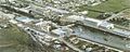
The Mataura Paper Mill used to operate on the river until 2000.
-
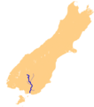
A map showing the Mataura River in New Zealand.
