Athol, New Zealand facts for kids
Quick facts for kids
Athol
|
|
|---|---|

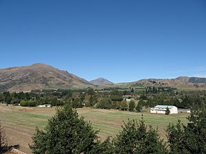
Athol – March 2014
|
|
| Country | New Zealand |
| Island | South Island |
| Region | Southland region |
| Territorial authority | Southland District |
| Population
(2006)
|
|
| • Total | 87 |
| Time zone | UTC+12 (NZST) |
| • Summer (DST) | UTC+13 (NZDT) |
| Postcode(s) |
9749
|
| Area code(s) | 03 |
| Local iwi | Ngāi Tahu |
Athol is a small town located in Southland, New Zealand. You can find it on State Highway 6, about 55 kilometers south of Queenstown. It's right in the middle of the journey between Lumsden and Kingston, along the beautiful Southern Scenic Route.
For a long time, farming has been a very important activity in this area. In earlier days, people also mined for gold, especially near the Nokomai. In recent years, more and more tourists have started visiting Athol. The Mataura River is well known for its excellent brown trout fishing. Also, the Around the Mountains Cycle Trail, which opened in November 2014, has brought even more visitors to the town.
How Did Athol Get Its Name?
It's not completely clear how Athol got its name. The town was first surveyed in 1863, and that's the first time its name was officially recorded.
- Hotel Owner Idea: One idea is that it was named after Harry Athol, who owned the first hotel there. However, there isn't much old information about a person with that exact name. It might be a mix-up with Harry Arthur, who ran an accommodation house in Athol in the 1860s.
- Scotland Connection: Another idea suggests it was named after the home area in Scotland of an early landowner, W. B. Rogers. But Rogers was born in New Zealand, and his father came from England, so this idea is probably not correct.
It seems most likely that Athol was named after Atholl, a place in Perthshire, Scotland. This might be because Dr. James Menzies, who was the Superintendent of Southland Province when the town was surveyed, came from that part of Scotland.
Athol's Location and Landscape
Athol is located 275 meters (about 900 feet) above sea level. It sits on a small flat area surrounded by mountains. To the south, you can see the Mid Dome mountain, which is 1478 meters high. To the east is Flagstaff mountain, standing at 1037 meters.
West of the town, the Eyre Creek flows, along with the smaller Quoich Creek. These two creeks join the Mataura River about 2 kilometers south of Athol.
Famous People from Athol
Some notable people have connections to Athol:
- Patrick Quirk Caples (around 1830 – 1904): He was an explorer and gold prospector. He mined for gold in an area called Paddy's Alley in the mid-1860s.
- Adam Hamilton (1880–1952): He was the first leader of the New Zealand National Party, a major political party in New Zealand. Before that, he worked as a Presbyterian home missionary in Athol in 1910.
- Ack Soper (1936–2020): He was a well-known New Zealand rugby union player.
 | Valerie Thomas |
 | Frederick McKinley Jones |
 | George Edward Alcorn Jr. |
 | Thomas Mensah |


