
Foveaux Strait facts for kids

Foveaux Strait is a waterway in New Zealand. It separates Stewart Island, New Zealand's third largest island, from the South Island. In the Māori language, it is called Te Ara a Kiwa ("the path of Kiwa") or Te Ara a Kewa ("the path of the whale"). A Māori legend says that the strait was made by Kewa the obedient whale. This happened when the traditional Māori ancestor Kiwa asked the whale to create a waterway.
Three large bays are found along the strait's northern coast. These are Te Waewae Bay, Oreti Beach and Toetoes Bay. The town and harbour of Bluff are also on this coast. Across the strait are the Solander Islands, Stewart Island, Dog Island and Ruapuke Island. The strait is about 130 kilometres (81 miles) long. It gets wider from east to west, from 14 kilometres (8.7 miles) at Ruapuke Island to 50 kilometres (31 miles) at Te Waewae Bay. It also gets deeper from east to west, from 20 to 120 metres (66 to 394 feet). The strait is part of New Zealand's continental shelf. It was likely dry land during the Pleistocene Ice Age.
Contents
History of Foveaux Strait
Early European Sightings
Some people believe that James Cook might have seen Foveaux Strait in March 1770. This was during his trip around the South Island. However, others think he simply made a mistake. Cook was focused on finding the southern end of New Zealand. Also, the weather conditions were not good for exploring the possible strait closely.
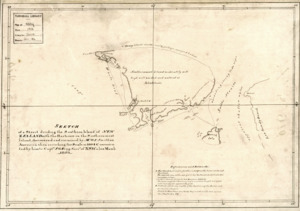
Charting the Strait
The strait was first properly mapped by Owen Folger Smith. He was from New York. Smith charted the strait in 1804 using a whaleboat. On his map from 1806, he named it Smith's Straits. This map was given to Governor Philip Gidley King. However, the map was not made public at that time.
The sealing ship Pegasus, led by Eber Bunker, got stuck in the strait in 1809. In the news report about this in the Sydney Gazette, the strait was called Foveaux Strait. It was named after Joseph Foveaux. He was the Lieutenant-Governor of New South Wales from 1808 to 1809.
Life and Work in the Strait
Whaling and Oysters
In the 1800s, whaling stations were set up along the shores of Foveaux Strait. These were places where whales were processed.
Today, Foveaux Strait is famous for its Bluff oyster fishery. These oysters are harvested by special dredging boats. Most of these boats work from Bluff Harbour on the South Island. The oyster season runs from March to August each year. Oystering first started on Stewart Island in the 1860s. It then moved into the strait when larger oyster beds were found there in 1879.

Challenges of the Waterway
Foveaux Strait is known for being a rough and sometimes dangerous stretch of water. It is located in the area known as the Roaring Forties. This means it often has strong winds and big waves. Between 1998 and 2012, some people unfortunately lost their lives in the strait due to boating incidents. For example, in 2006, a fishing boat sank while returning to Bluff.
Despite its challenges, some people have swum across the strait. John van Leeuwen swam it on February 7, 1963. He completed the swim in 13 hours and 40 minutes.
See also
 In Spanish: Estrecho de Foveaux para niños
