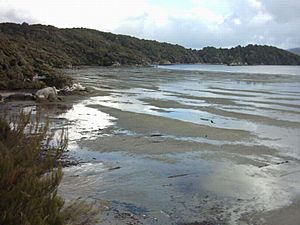
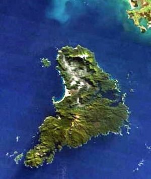
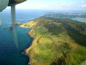
Stewart Island facts for kids
|
Native name:
Rakiura (Māori)
|
|
|---|---|
 |
|
 |
|
| Geography | |
| Location | Foveaux Strait |
| Coordinates | 47°00′S 167°50′E / 47.00°S 167.84°E |
| Archipelago | New Zealand archipelago |
| Area | 1,747.72 km2 (674.80 sq mi) |
| Highest elevation | 980 m (3,220 ft) |
| Highest point | Mount Anglem / Hananui |
| Administration | |
| Electorates | Invercargill (general) Te Tai Tonga (Māori) |
| MPs | Penny Simmonds (New Zealand National Party) Tākuta Ferris (Te Pāti Māori) |
|
Local Government
|
|
| Regional Council | Environment Southland |
| Largest settlement | Oban |
| Territorial authority | Southland District |
| Community Board | Stewart Island/Rakiura Community Board |
| Demographics | |
| Population | 450 (June 2023) |
| Pop. density | 0.26 /km2 (0.67 /sq mi) |
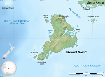
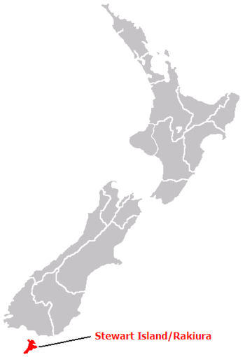
Stewart Island (which Māori people call Rakiura, meaning 'glowing skies') is officially known as Stewart Island / Rakiura. It is New Zealand's third-largest island. You can find it about 30 kilometres (16 nautical miles) south of the South Island, across a stretch of water called Foveaux Strait.
This island is shaped roughly like a triangle and covers about 1,746 square kilometres (674 square miles). Its coastline is 164 kilometres (102 miles) long and has many deep bays, like Paterson Inlet on the east, Port Pegasus in the south, and Mason Bay in the west. The island is mostly hilly, with its highest point being Mount Anglem, which is 980 metres (3,215 feet) tall. It's also covered in thick forests. Many flightless birds, including penguins, live here safely because there are not many introduced animals that hunt them. Most of the island belongs to the New Zealand government, and over 80 percent of it is protected as the Rakiura National Park.
Stewart Island's economy relies on fishing and the many tourists who visit in summer. In 2018, 408 people lived there permanently. Most of them live in the main town called Oban, on the eastern side of the island. Ferries connect Oban to Bluff on the South Island. Stewart Island is part of the Southland District for local government.
Contents
Island History and Names
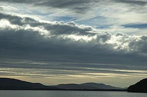
Scientists believe people first settled on Stewart Island in the 1300s. This was soon after the Māori people arrived in the South Island.
The original Māori name for the island is Te Punga o Te Waka a Māui. This name connects the island to an important Māori story. It means "The Anchor Stone of Māui’s Canoe." This refers to the legend of Māui and his crew. They used their canoe, Te Waka a Māui (which is the South Island), to fish up the great fish, Te Ika a Māui (which is the North Island). Stewart Island was the anchor that held their canoe in place.
The most common Māori name today is Rakiura. This usually means "Glowing Skies." It refers to the aurora australis, also known as the southern lights. These beautiful lights are often seen in the night sky in southern parts of the world.
Some people say Rakiura is a shorter version of Te Rakiura a Te Rakitamau. This means "great blush of Rakitamau." It tells the story of a chief named Te Rakitamau. He was embarrassed when two daughters of an island chief refused to marry him.
In 1770, James Cook sailed near the island. He might have known it was a separate island but didn't clearly mark it on his maps. Later, in 1804, an American sealer named Owen Folger Smith explored the strait between the islands. He named it Smith's Straits.
The island got its English name from William W. Stewart. He was an officer on the ship Pegasus, which visited in 1809. He mapped the large harbour in the southeast, which is now called Port Pegasus. He also proved that Stewart Island was a separate island. In 1826, he helped start a settlement there, and the island became known as Stewart's Island.
For a long time, "Stewart Island" was the official name. But in 1998, the name was officially changed to Stewart Island/Rakiura. This was part of an agreement with the Ngāi Tahu Māori tribe.
Geography and Nature
Stewart Island covers about 1,680 square kilometres (649 square miles). It has a hilly landscape and a mild, wet climate, like much of New Zealand. The northern part of the island has a large swampy valley called the Freshwater River. This river flows into Paterson Inlet. The highest point is Mount Anglem, which is 980 metres (3,215 feet) high.
The southern part of the island is more gently rolling. It has a ridge that runs south from the Rakeahua River valley. The southernmost point of New Zealand's main islands is South West Cape, located on Stewart Island.
Mason Bay, on the west side, is famous for its long sandy beach. Most other beaches on the island are much rockier.
Many smaller islands surround Stewart Island. Some important ones include Ruapuke Island in Foveaux Strait, Codfish Island / Whenua Hou near the northwest coast, and Big South Cape Island off the southwest tip. The Tītī / Muttonbird Islands are also nearby. Other interesting islands are Ulva Island near Paterson Inlet, and Anchorage Island near Port Pegasus.
Stewart Island has a mild climate. However, it often rains, so waterproof clothing and boots are a good idea! The main town, Oban, gets about 1,600 to 1,800 millimetres (63 to 71 inches) of rain each year.
Because of its location, Stewart Island is a great place to see the Aurora australis, or southern lights.
About 18,000 years ago, during the last Ice Age, sea levels were much lower. At that time, Stewart Island was connected to the rest of New Zealand. The sea levels rose about 7,000 years ago, separating Stewart Island from the mainland.
Towns and Settlements
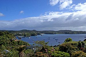
The only town on Stewart Island is Oban, located on Halfmoon Bay.
There used to be another settlement called Port Pegasus on the southern coast. It had shops and a post office. Today, no one lives there, and you can only reach it by boat or a very difficult hike. Another old settlement was at Port William. People from the Shetland Islands tried to settle there in the 1870s, but it didn't work out, and they left after a year or two.
Dark Sky Sanctuary
In January 2019, Stewart Island was named a Dark Sky Sanctuary by the International Dark-Sky Association. This means it's a very remote place with incredibly dark night skies. This helps people appreciate the stars and encourages protecting the dark sky for the future. This special title helps attract more visitors to the island, especially during the winter.
Rakiura National Park
Over 80 percent of Stewart Island is part of the Rakiura National Park. This park helps protect the island's unique plants and animals.
Climate
| Climate data for Oban, Stewart Island (1991–2020 normals, extremes 1975–present) | |||||||||||||
|---|---|---|---|---|---|---|---|---|---|---|---|---|---|
| Month | Jan | Feb | Mar | Apr | May | Jun | Jul | Aug | Sep | Oct | Nov | Dec | Year |
| Record high °C (°F) | 30.6 (87.1) |
28.5 (83.3) |
26.5 (79.7) |
29.0 (84.2) |
20.5 (68.9) |
17.5 (63.5) |
16.0 (60.8) |
17.1 (62.8) |
21.3 (70.3) |
25.0 (77.0) |
26.5 (79.7) |
28.5 (83.3) |
30.6 (87.1) |
| Mean daily maximum °C (°F) | 17.6 (63.7) |
17.5 (63.5) |
16.2 (61.2) |
14.4 (57.9) |
12.4 (54.3) |
10.4 (50.7) |
10.1 (50.2) |
10.8 (51.4) |
12.5 (54.5) |
13.6 (56.5) |
14.9 (58.8) |
16.7 (62.1) |
13.9 (57.1) |
| Daily mean °C (°F) | 13.6 (56.5) |
13.5 (56.3) |
12.3 (54.1) |
10.7 (51.3) |
9.0 (48.2) |
7.0 (44.6) |
6.5 (43.7) |
7.2 (45.0) |
8.6 (47.5) |
9.7 (49.5) |
10.9 (51.6) |
12.7 (54.9) |
10.1 (50.3) |
| Mean daily minimum °C (°F) | 9.6 (49.3) |
9.5 (49.1) |
8.4 (47.1) |
7.0 (44.6) |
5.7 (42.3) |
3.6 (38.5) |
2.8 (37.0) |
3.7 (38.7) |
4.8 (40.6) |
5.7 (42.3) |
7.0 (44.6) |
8.7 (47.7) |
6.4 (43.5) |
| Record low °C (°F) | 1.0 (33.8) |
0.9 (33.6) |
0.7 (33.3) |
−0.4 (31.3) |
−6 (21) |
−7.3 (18.9) |
−6 (21) |
−7 (19) |
−4.5 (23.9) |
−1.8 (28.8) |
−0.4 (31.3) |
0.6 (33.1) |
−7.3 (18.9) |
| Average rainfall mm (inches) | 138.4 (5.45) |
106.9 (4.21) |
139.3 (5.48) |
118.7 (4.67) |
155.3 (6.11) |
139.6 (5.50) |
130.8 (5.15) |
116.0 (4.57) |
122.8 (4.83) |
146.5 (5.77) |
134.4 (5.29) |
116.3 (4.58) |
1,565 (61.61) |
| Average rainy days (≥ 1.0 mm) | 15.3 | 13.6 | 15.4 | 16.0 | 17.9 | 17.8 | 17.0 | 16.5 | 16.0 | 17.0 | 17.0 | 16.1 | 195.5 |
| Average relative humidity (%) | 84.3 | 87.4 | 87.4 | 89.4 | 91.1 | 90.9 | 91.3 | 89.9 | 85.0 | 84.3 | 81.6 | 82.6 | 85.8 |
| Source: NIWA (rainy days and humidity 1975–2015) | |||||||||||||
People of Stewart Island
| Historical population | ||
|---|---|---|
| Year | Pop. | ±% p.a. |
| 2006 | 402 | — |
| 2013 | 378 | −0.88% |
| 2018 | 408 | +1.54% |
Stewart Island, including its smaller islands, covers about 1,747 square kilometres (675 square miles). As of 2023, about 450 people live there. This means there are about 0.26 people per square kilometre.
In the 2018 New Zealand census, 408 people lived on Stewart Island. This was a small increase from previous years. There were slightly more males than females. The average age was 49.3 years. About 13.2% of the people were under 15 years old.
Most people (93.4%) identified as European/Pākehā. About 19.9% identified as Māori. Some people also identified with other ethnic groups. About 16.9% of the people were born outside New Zealand.
When asked about religion, most people (67.6%) said they had no religion. About 23.5% were Christian.
Island Economy
Fishing has always been very important to Stewart Island's economy. While it is still a key industry, tourism has become the main way people on the island earn money. Some farming and forestry have also taken place.
Plants and Animals
Unique Flora
Even though the soil isn't super rich, the island has lots of rain and warm weather. This means it's covered in dense forests. You can find the world's southernmost thick forests of podocarps (a type of conifer) and hardwood trees like rātā and kāmahi. Higher up, you'll see mānuka shrubs. It's thought that these trees grew here after the last ice age. Their seeds were likely carried across the strait by seabirds. This might explain why beech trees, which are common in New Zealand but spread by wind, are not found on Stewart Island.
In the 1930s, a woman named Noeline Baker bought land near Halfmoon Bay. She planted all the local native plants there. In 1940, she gave her land and house to the government. Today, this place is called Moturau Moana, New Zealand's southernmost public garden.
Amazing Fauna
Stewart Island is home to many bird species that are thriving. This is because there are very few predators like cats, rats, stoats, and ferrets that humans brought to the main islands. Even more birds, including huge groups of sooty shearwaters and other seabirds, live on The Snares and other small islands nearby.
Birds you can find on Stewart Island include weka, kākā, albatross, the flightless Stewart Island kiwi, silvereyes, fantails, and kererū. The endangered yellow-eyed penguin has many places to breed here. Large groups of sooty shearwaters on the offshore Muttonbird Islands are part of a traditional Māori harvesting program called muttonbirding.
A small group of kākāpō, a flightless parrot that is very rare, was found on Stewart Island in 1977. These birds were then moved to smaller islands like Codfish Island / Whenua Hou to protect them from wild cats. The South Island saddleback is also protected in a similar way. Stewart Island is the only place where the critically endangered southern New Zealand dotterel still breeds.
Threats and Preservation Efforts
Stewart Island has always had a small population. There hasn't been much logging. This means that most of the original wildlife is still safe. This includes species that have disappeared from the main islands of New Zealand.
However, there are still some introduced animals on the island. These include brushtail possums, wild cats, hedgehogs, and three types of rats. But there are no mustelids (like stoats) or mice. There are also many white-tailed deer, which were brought to the island and are hunted for food and sport. A smaller group of red deer lives in the island's inland areas.
Almost all of Stewart Island is owned by the New Zealand government. Over 80 percent of the island is protected as the Rakiura National Park. Many of the small islands offshore, like the Snares, are also protected areas.
Getting Around Stewart Island
Ferry Services
The ferry trip across Foveaux Strait from Bluff Harbour on the South Island to Oban on Stewart Island is about 39 kilometres (21 nautical miles) long. Today, a fast catamaran ferry usually takes about one hour. The company RealNZ operates this ferry service.
History of Ferries
The first regular ferry service across Foveaux Strait started in 1877. It delivered mail weekly but soon carried passengers and goods too. Over the years, many different ships were used. In 1960, a new ship called the Wairua was built. It was the largest ship built in New Zealand at that time. The Wairua started service in 1961 and was the first ship in New Zealand with special features to stop it from rolling too much in rough seas. By 1985, the government decided the ferry service was losing too much money. Private companies were then invited to run the service.
Private companies took over the ferry service in 1985. A new ferry was built in 1999. In 2004, the ferry service was sold to Stewart Island Experience, a company that later became part of RealNZ.
Air Services
Stewart Island Flights offers plane services across Foveaux Strait. They fly between Invercargill Airport and Ryan's Creek Aerodrome on Stewart Island. Their planes can also land on the sand at Mason Bay, Doughboy Bay, and West Ruggedy Beach.
History of Air Travel
In 1950, a company called Amphibian Airways was allowed to start an air service to Stewart Island. Their first flight to Half Moon Bay was in March 1951. Later, in 1980, a sealed airstrip was built at Ryan's Creek, near Oban. Planes like the Nomad and Britten-Norman Islander were used for flights from Invercargill. The company changed its name to Southern Air and then to Stewart Island Flights in 2020.
Roads on the Island
In Oban, the main roads are sealed (paved), but some roads on the edges of town are gravel. If you want to bring a vehicle to Stewart Island, the only way is by ferry/barge from Bluff.
Island Infrastructure
Communications
On Stewart Island, you can listen to most AM and FM radio stations from the Southland region. Television is available through satellite services like Sky or Freeview.
Oban has ADSL broadband internet and phone services. You can get speeds up to 24 megabits per second for downloading.
Mobile phone companies like Spark, 2degrees, and One NZ all offer 3G coverage. Spark also has 4G coverage. All these services come to the island through a radio link from Bluff.
Electricity
Since 1988, Stewart Island has gotten its electricity from diesel generators. Before that, people used their own small generators. Because of this, electricity on the island is about three times more expensive than on the South Island. There have been plans to use wind turbines to generate electricity, but these plans have faced challenges.
Fun Facts and Promotions
People on Stewart Island have sometimes held fun events to pretend the island is independent. They even sold "passports" for 50 cents to raise money for a new swimming pool at the school. In 1970, they had a mock ceremony where they declared independence and showed a new flag. These were just for fun and fundraising. Stewart Island is still very much a part of New Zealand!
|
See also
 In Spanish: Isla Stewart para niños
 | Audre Lorde |
 | John Berry Meachum |
 | Ferdinand Lee Barnett |


