Ruapuke Island facts for kids
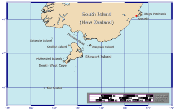
Ruapuke Island is one of the southernmost islands in New Zealand. It is located about 15 kilometers (9 miles) southeast of Bluff. It is also 32 kilometers (20 miles) northeast of Oban on Stewart Island/Rakiura.
Captain James Cook first saw the island in 1770. He named it "Bench Island." However, most people have always called it by its Māori name, Ruapuke. This name means "two hills." The island was also called Goulburn Island for a short time. Whalers often called it Long Island. Ruapuke Island is about 16 square kilometers (6 square miles) in size. It sits at the eastern end of Foveaux Strait.
Contents
Exploring Ruapuke Island's Past
Ruapuke Island once had a Māori population of 200 people. Important Māori leaders lived here. One famous person was Kāi Tahu chief Tūhawaiki. Another was John Topi Patuki.
In 1843, a mission station was started on the island. It was set up by Rev Johan Wohlers. This station is no longer there today.
Shipwrecks and Dangers at Sea
Many ships crashed near Ruapuke Island in the late 1800s. Luckily, most of these accidents did not cause anyone to lose their life. But in April 1894, two small ships, the "Annie" and "Deveron," crashed during a storm. Two people died in that accident.
The island and its rocky areas are still risky for fishing boats. Foveaux Strait is known for being a very dangerous area for ships.
Life on the Island Today
For some time, sheep were raised on Ruapuke Island. However, no one lives on the island now. It is owned by the family members of Chief Tūhawaiki.
The island is a special place for birds. It is a breeding spot for the endangered yellow-eyed penguin. You might also see large sea animals like southern right whales around the island. They pass by during their migration seasons.
Discovering Ruapuke Island's Geography
The middle part of Ruapuke Island is mostly flat. It is about 41 meters (135 feet) high. There are small hills, called hummocks, on the north, south, and west sides. The island is mostly covered with small trees. It also has open scrubland and some wet marshy areas.
Major Landforms and Bays
Ruapuke Island has three large bays. The biggest one is Henrietta Bay, located in the southwest. It was named after a ship called the Elizabeth Henrietta. This ship got stuck there in 1824. The other bays are Lagoon Bay in the west and Caroline Bay in the northwest.
A small body of water called Waitokariro Lagoon is just inland from Henrietta Bay. The three bays are separated by two large pieces of land that stick out into the sea, called peninsulas. Two more peninsulas are at the very northern and southern ends of the island. These end points are called North Head and South Head.
One of these peninsulas, between Lagoon and Caroline Bays, is a tombolo. This is a narrow strip of land connecting an island to the mainland or another island. North Head is a steep cliff that rises to a hummock, about 62 meters (203 feet) high. The island's highest point is about 64 meters (210 feet) above sea level. It is located near the westernmost point, on the peninsula between Lagoon Bay and Henrietta Bay. These two highest hummocks give the island its name, "two hills."
Coastline and Surrounding Islands
The eastern coast of Ruapuke Island has two long, straight beaches in the north. To the south, there are many smaller coves. Between the longer beaches and the smaller coves, there is an inlet. This is where the island's only river system flows into the sea.
A smaller island called Green Island is about 100 hectares (247 acres) in size. It lies about 2 kilometers (1.2 miles) off the central east coast. Another small island, Bird Island, is about one-third the size of Green Island. It is located about 3.5 kilometers (2.2 miles) west of Ruapuke's westernmost point.
Other small islands and groups of islands can be found around Ruapuke's coast. The South Islets are a group of small islands just south of South Head. None of them are larger than 10 hectares (25 acres). Beyond these, to the southwest, is the Hazelburgh Islet group, which is similar in size. Between Green Island and South Head, there is another small group called the Breaksea Islands. Many other smaller rocks and reefs are also found around the island.
See also
 In Spanish: Isla Ruapuke para niños
 | William M. Jackson |
 | Juan E. Gilbert |
 | Neil deGrasse Tyson |


