
Port Pegasus facts for kids
Port Pegasus, also known as Port Pegasus / Pikihatiti, is a special place at the very bottom of Stewart Island in New Zealand. It used to be called South Port. For about 60 years, from the 1890s to the 1950s, a small group of people lived here. They mostly worked as fishers. There was also a short period in the 1890s when people tried to mine for tin here. Today, no one lives permanently at Port Pegasus. But many visitors come to explore, including tourists, fishers, hunters, and divers.
Contents
Exploring Port Pegasus's Past
How Port Pegasus Got Its Name
In 1809, a man named William W. Stewart visited and mapped this island. He first called the bay "South Port." Later, the bay was renamed "Port Pegasus." This new name honored the ship Pegasus, which Stewart sailed on.
The Pegasus was originally a ship called Pegaso. British forces captured it in 1807 near Peru. It was then sold and renamed Pegasus. In 1808, the ship was bought by Thomas Moore. It was prepared for a trip to hunt seals in southern New Zealand.
Captain Eber Bunker commanded the Pegasus on this first trip. It lasted from August 1808 to March 1809. William Stewart was an officer on a second trip. He made important maps of the New Zealand coast. This included the island that was later named after him: Stewart Island.
Mapping the Coastline
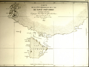
A French officer named Jules de Blosseville first used the name Port Pegasus. He put it on his map in 1824. This map showed the southern coast of New Zealand. Blosseville was part of an expedition on the ship Coquille.
His expedition did not visit southern New Zealand directly. But Blosseville gathered information from other captains. He spoke with Captain William Edwardson and seal hunting captains. Blosseville used this information to create his detailed maps. These maps were published in 1827.
Rediscovering the Kākāpō
In the late 1970s, something exciting happened near Port Pegasus. The Kākāpō was found again near the Tin Range. The Kākāpō is a very rare, flightless parrot. This rediscovery was a big moment for conservation.
Getting to Port Pegasus
Port Pegasus / Pikihatiti is not easy to reach. You can only get there by boat. Or you can hike a very tough trail from Oban. This trail was first marked by a ranger named Roy Traill.
