
Manapouri facts for kids
Quick facts for kids
Manapouri
|
|
|---|---|

Manapouri township
|
|
| Country | New Zealand |
| Island | South Island |
| Region | Southland region |
| Territorial authorities of New Zealand | Southland District |
| Ward | Mararoa Waimea Ward |
| Community | Fiordland Community |
| Electorates |
|
| Area | |
| • Total | 1.36 km2 (0.53 sq mi) |
| Elevation | 200 m (700 ft) |
| Population
(June 2023)
|
|
| • Total | 240 |
| • Density | 176/km2 (457/sq mi) |
| Local iwi | Ngāi Tahu |
Manapouri is a small town in the Southland region of New Zealand. It's located in the southwest corner of the South Island. Manapouri sits right on the edge of the amazing Fiordland National Park.
The town is on the eastern shore of Lake Manapouri. This lake is known for its beautiful scenery. Manapouri is also a starting point for many fun tourist activities. You can take boat trips from here to explore the area.
Manapouri is about a 20-minute drive from Te Anau on State Highway 95. It's often called the "gateway" to famous places like Doubtful Sound and Dusky Sound. Many visitors come here, especially in summer.
Contents
Manapouri's Past
Manapouri has an important place in New Zealand's history. There's a special monument at the crossroads of State Highway 95 and Hillside Road. This monument celebrates the Save Manapouri campaign. It was the first big environmental movement in New Zealand. People worked together to protect the lake and its surroundings.
The Manapouri Power Station
The Manapouri Hydroelectric Power Station is a huge power plant. It's located on the West Arm of Lake Manapouri. This station uses the power of water to create electricity. Most of this electricity goes to the Tiwai Point Aluminium Smelter.
Workers get to the power station by boat from Manapouri. There are no roads that lead directly to it. This power station uses a lot of water from the lake.
Fun Things to Do in Manapouri
Manapouri has many services for visitors and locals. You can find places to get petrol, art galleries, and cafes. There are also shops and restaurants. If you want to stay overnight, there are hotels, motels, and camping spots.
The small Te Anau Airport is just 5 kilometers north of town. It serves both Te Anau and Manapouri.
Boat Trips and Tours
Manapouri is a great place for boat trips. You can take tours to the amazing Fiordland Sounds. There are also fishing trips and boats you can rent.
Many tours start at Pearl Harbour. This is at the southern end of Manapouri town. You can take a boat across Lake Manapouri. Some tours even let you see the underground power station! After that, you might take a bus over Wilmot Pass for boat tours of Doubtful Sound. It's a full day of adventure!
Walking and Biking Trails
If you love walking, Manapouri has several day walks. These include the Circle Track and the Hope Arm Track. You can also explore the Shallow Bay part of the Kepler Track. The Frazers Beach Reserve also has nice walkways.
For biking, Supply Bay Road and the Rainbow Reach area are good choices. There's also a plan for a Manapouri-Te Anau Cycle trail.
Across the lake from Manapouri is a natural landmark called Monument Hill. It's a sharply pointed hill under the Hunter Mountains. It's a popular spot for adventurous hikers.

Kayaking Adventures
The eastern part of Lake Manapouri is perfect for kayaking. It has 20 islands to explore! You'll find many coves, beaches, and lagoons. There are also waterfalls, huts, and channels. You can paddle around for a whole day and return to Manapouri town.

Manapouri and The Lord of the Rings
Manapouri was a filming location for Peter Jackson's famous The Lord of the Rings movies.
One time, during a late snowstorm in November, Manapouri Hall was used for filming. It became the scene in The Two Towers where Frodo, Samwise, and Gollum try to enter the Black Gates of Mordor. The townspeople were very kind to the film crew. They only asked for a small fee to use the hall. But the movie production gave a large amount of money to help fix up the hall.
The film crew wasn't allowed to use real granite boulders from the forest. So, they made their own fake rocks. Two of these artificial rocks were given to the townspeople as a gift!
Other places near Manapouri were also used for filming. The Kepler Mire was used for aerial shots of the Dead Marshes. The Waiau River became parts of the River Anduin. The Norwest Lakes were used for the famous shot of the fellowship walking across mountain peaks. It's even rumored that parts of the Fiordland National Park near Manapouri were used for The Rings of Power TV series.
The Wee Bookshop
Manapouri is home to a very special place called the Wee Bookshop. It became famous because of a book written by Ruth Shaw. The bookshops were built in 2020. They first sold books about the local area and nature.
Now, there are actually three tiny bookshops! One is for adults, a smaller one is just for children, and there's even one for "the blokes" (a friendly term for men).
Manapouri's Weather
Manapouri has a mild climate. Summers are usually gentle, and winters are cool or cold. It often snows a few times during winter.
| Climate data for Manapouri (1991–2020 normals, extremes 1991-present) | |||||||||||||
|---|---|---|---|---|---|---|---|---|---|---|---|---|---|
| Month | Jan | Feb | Mar | Apr | May | Jun | Jul | Aug | Sep | Oct | Nov | Dec | Year |
| Record high °C (°F) | 32.0 (89.6) |
30.7 (87.3) |
28.8 (83.8) |
23.8 (74.8) |
21.3 (70.3) |
18.2 (64.8) |
16.1 (61.0) |
18.1 (64.6) |
22.3 (72.1) |
24.0 (75.2) |
26.4 (79.5) |
29.2 (84.6) |
32.0 (89.6) |
| Mean maximum °C (°F) | 27.6 (81.7) |
27.4 (81.3) |
24.6 (76.3) |
20.4 (68.7) |
17.7 (63.9) |
14.7 (58.5) |
14.0 (57.2) |
15.0 (59.0) |
18.3 (64.9) |
21.0 (69.8) |
23.2 (73.8) |
26.0 (78.8) |
28.6 (83.5) |
| Mean daily maximum °C (°F) | 20.7 (69.3) |
20.5 (68.9) |
18.4 (65.1) |
15.0 (59.0) |
11.8 (53.2) |
8.7 (47.7) |
8.3 (46.9) |
10.3 (50.5) |
12.9 (55.2) |
14.8 (58.6) |
16.7 (62.1) |
19.2 (66.6) |
14.8 (58.6) |
| Daily mean °C (°F) | 14.7 (58.5) |
14.4 (57.9) |
12.3 (54.1) |
9.6 (49.3) |
7.2 (45.0) |
4.5 (40.1) |
4.0 (39.2) |
5.3 (41.5) |
7.5 (45.5) |
9.3 (48.7) |
10.9 (51.6) |
13.3 (55.9) |
9.4 (48.9) |
| Mean daily minimum °C (°F) | 8.6 (47.5) |
8.2 (46.8) |
6.3 (43.3) |
4.2 (39.6) |
2.5 (36.5) |
0.3 (32.5) |
−0.4 (31.3) |
0.4 (32.7) |
2.2 (36.0) |
3.8 (38.8) |
5.2 (41.4) |
7.4 (45.3) |
4.1 (39.4) |
| Mean minimum °C (°F) | 0.9 (33.6) |
0.5 (32.9) |
−1.3 (29.7) |
−2.6 (27.3) |
−3.5 (25.7) |
−4.8 (23.4) |
−5.5 (22.1) |
−5.0 (23.0) |
−4.1 (24.6) |
−2.7 (27.1) |
−1.7 (28.9) |
0.2 (32.4) |
−6.1 (21.0) |
| Record low °C (°F) | −3.6 (25.5) |
−2.0 (28.4) |
−5.5 (22.1) |
−5.2 (22.6) |
−5.9 (21.4) |
−7.2 (19.0) |
−10.2 (13.6) |
−8.2 (17.2) |
−5.9 (21.4) |
−7.3 (18.9) |
−3.7 (25.3) |
−2.5 (27.5) |
−10.2 (13.6) |
| Average rainfall mm (inches) | 88.6 (3.49) |
85.3 (3.36) |
82.7 (3.26) |
85.0 (3.35) |
104.4 (4.11) |
91.4 (3.60) |
94.2 (3.71) |
82.0 (3.23) |
106.2 (4.18) |
113.0 (4.45) |
95.7 (3.77) |
97.4 (3.83) |
1,125.9 (44.34) |
| Average rainy days (≥ 1.0 mm) | 9.5 | 8.0 | 9.6 | 10.2 | 12.3 | 11.9 | 11.7 | 10.9 | 12.0 | 12.7 | 10.5 | 11.0 | 130.3 |
| Average relative humidity (%) | 77.5 | 83.3 | 86.2 | 88.5 | 91.0 | 92.1 | 92.3 | 91.8 | 86.0 | 82.6 | 76.9 | 76.0 | 85.3 |
| Source: NIWA Climate Data | |||||||||||||
| Climate data for Manapouri (West Arm Jetty) (1991–2020 normals, extremes 1962-present) | |||||||||||||
|---|---|---|---|---|---|---|---|---|---|---|---|---|---|
| Month | Jan | Feb | Mar | Apr | May | Jun | Jul | Aug | Sep | Oct | Nov | Dec | Year |
| Record high °C (°F) | 31.6 (88.9) |
31.1 (88.0) |
28.1 (82.6) |
21.4 (70.5) |
16.6 (61.9) |
18.7 (65.7) |
18.7 (65.7) |
15.9 (60.6) |
19.8 (67.6) |
23.2 (73.8) |
27.5 (81.5) |
29.4 (84.9) |
31.6 (88.9) |
| Mean maximum °C (°F) | 26.8 (80.2) |
26.4 (79.5) |
23.3 (73.9) |
18 (64) |
14.1 (57.4) |
11.6 (52.9) |
10.5 (50.9) |
12.1 (53.8) |
16.2 (61.2) |
19.4 (66.9) |
22.8 (73.0) |
25.9 (78.6) |
27.9 (82.2) |
| Mean daily maximum °C (°F) | 19.4 (66.9) |
19.1 (66.4) |
16.8 (62.2) |
13.2 (55.8) |
9.7 (49.5) |
6.7 (44.1) |
6.0 (42.8) |
7.9 (46.2) |
11.0 (51.8) |
13.2 (55.8) |
15.4 (59.7) |
17.9 (64.2) |
13.0 (55.5) |
| Daily mean °C (°F) | 14.5 (58.1) |
14.2 (57.6) |
12.3 (54.1) |
9.6 (49.3) |
6.9 (44.4) |
4.2 (39.6) |
3.4 (38.1) |
4.9 (40.8) |
7.2 (45.0) |
8.9 (48.0) |
10.8 (51.4) |
13.1 (55.6) |
9.2 (48.5) |
| Mean daily minimum °C (°F) | 9.6 (49.3) |
9.3 (48.7) |
7.8 (46.0) |
5.9 (42.6) |
4.1 (39.4) |
1.7 (35.1) |
0.7 (33.3) |
1.8 (35.2) |
3.4 (38.1) |
4.7 (40.5) |
6.2 (43.2) |
8.3 (46.9) |
5.3 (41.5) |
| Mean minimum °C (°F) | 4.1 (39.4) |
3.8 (38.8) |
2.5 (36.5) |
0.2 (32.4) |
−1.1 (30.0) |
−2.6 (27.3) |
−3.7 (25.3) |
−2.6 (27.3) |
−1.7 (28.9) |
−0.8 (30.6) |
0.9 (33.6) |
2.8 (37.0) |
−4.3 (24.3) |
| Record low °C (°F) | −1.1 (30.0) |
−0.6 (30.9) |
−0.7 (30.7) |
−3.2 (26.2) |
−4.4 (24.1) |
−8.5 (16.7) |
−7.9 (17.8) |
−5.6 (21.9) |
−3.4 (25.9) |
−5.4 (22.3) |
−3.1 (26.4) |
−0.6 (30.9) |
−8.5 (16.7) |
| Average rainfall mm (inches) | 365.8 (14.40) |
249.4 (9.82) |
231.0 (9.09) |
275.3 (10.84) |
413.3 (16.27) |
271.2 (10.68) |
329.0 (12.95) |
253.7 (9.99) |
374.7 (14.75) |
377.3 (14.85) |
300.4 (11.83) |
311.8 (12.28) |
3,752.9 (147.75) |
| Source: NIWA | |||||||||||||
Images for kids
-
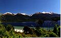
View from Frazers Beach Reserve
-
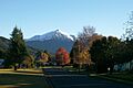
Autumn view along Mararoa Drive with snow-dusted Mount Moturau in the distance
-
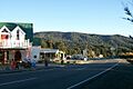
Manapouri commerce
-
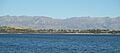
Manapouri township from Lake Manapouri


