Lake Manapouri facts for kids
Quick facts for kids Lake Manapouri |
|
|---|---|
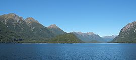
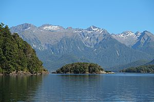
Lake Manapouri towards Turret Range and West Arm
|
|
| Location | Southland District, Southland Region, South Island |
| Coordinates | 45°30′S 167°30′E / 45.500°S 167.500°E |
| Primary inflows | Upper Waiau River |
| Primary outflows | Waiau River |
| Catchment area | 1,388 km2 (536 sq mi) |
| Basin countries | New Zealand |
| Max. length | 28 km (17 mi) |
| Surface area | 142 km2 (55 sq mi) |
| Max. depth | 444 m (1,457 ft) |
| Shore length1 | 170 km (110 mi) |
| Surface elevation | 177.8 m (583 ft) |
| Islands | 33 |
| Settlements | Manapouri |
| 1 Shore length is not a well-defined measure. | |
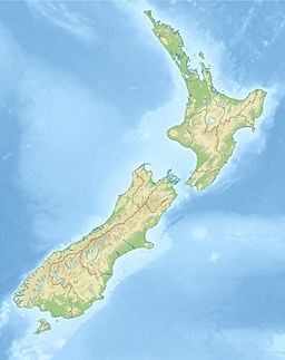
Lake Manapouri is a beautiful lake found in the South Island of New Zealand. It is located inside the Fiordland National Park. This park is part of the larger Te Wahipounamu World Heritage Area, which is a special place recognized globally for its natural beauty.
Contents
Māori Legends and Lake Manapouri's Name
According to Māori stories, Lake Manapouri was formed from the tears of two sisters, Moturua and Koronae. They were daughters of a local chief. One day, Koronae got lost and fell deep in the forest. Her sister, Moturua, found her but realized she couldn't be saved. Moturua stayed with Koronae until they both passed away. Their tears created the lake.
The name Manapouri means "anxious" or "sorrowful heart," reflecting the sisters' grief. However, the current name was given by mistake by an early settler. The lake's original Māori names are thought to be Roto-ua, meaning "Rainy Lake," and later Moturau, meaning "Many Islands."
Māori people have lived in this area for a long time. They found plenty of food around the lake, like eels and birds such as pigeons and New Zealand kaka (a type of forest parrot). Europeans first discovered Lake Manapouri in 1852. The explorers Charles J Nairn and W H Stevens were the first to find it.
Geography and Formation of Lake Manapouri
Lake Manapouri was shaped by huge sheets of ice called glaciers. This happened during the last ice age. It is New Zealand's second deepest lake, reaching 444 metres (1,457 ft) deep. The lake sits 178 metres (584 ft) above sea level. But because glaciers carved it so deeply, the very bottom of the lake is actually 267 metres (876 ft) below sea level!
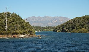
The lake has four main parts, or "arms": North, South, West, and Hope. It also has smaller areas like Shallow Bay and Calm Bay. Lake Manapouri is home to 33 islands. Twenty-two of these islands are covered in trees. Pomona Island is the largest island and is located near the center of the lake. Other big islands include Holmwood Island, Rona Island, and Mahara Island. The small town of Manapouri is on the lake's eastern side.
The Waiau River (Southland) naturally flows into and out of the lake. It enters the lake from the northeast, coming from Lake Te Anau, which is about 20 kilometres (12 mi) north. The river then flows out from Manapouri's southeastern end. However, the river's outflow has been changed. This is because of the Manapouri Hydroelectric Power Station. Now, water flows westwards to the sea at Deep Cove.
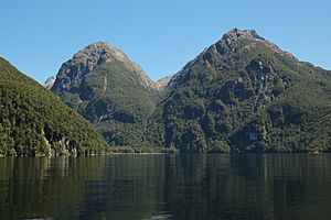
The area gets a lot of rain, especially in the western mountains. The western arm of Lake Manapouri receives about 3,786 millimetres (149.1 in) of rain each year. In contrast, Manapouri Township on the eastern side gets much less, around 1,143 millimetres (45.0 in) annually. Lake Manapouri collects water from a large area of 1,388 square kilometres (536 sq mi). This includes the Kepler Mountains, Turret Range, and Hunter Mountains, which surround most of the lake. Lake levels are usually high in spring due to melting snow and lower in winter. Many people say Lake Manapouri is New Zealand's most beautiful lake.
Lake Manapouri's Amazing Biodiversity
Lake Manapouri is famous for its excellent fishing and very clean water. Both Lake Manapouri and Lake Te Anau have extremely clear, oxygen-rich waters. This means they have very low amounts of tiny living things. These lakes, along with the connecting Waiau River, are home to the New Zealand longfin eel. You can also find introduced fish like brown trout, rainbow trout, and some Atlantic salmon. Luckily, an invasive plant called Lagarosiphon major, which causes problems in many other New Zealand lakes, is not found here.
Lake Manapouri provides a safe home for 73% of New Zealand's longfin eels. These eels are protected from commercial fishing in the lake. However, the number of longfin eels has decreased because of the hydroelectric dam. The dam blocks the eels' natural migration path. Eels can also be harmed when they pass through the dam's turbines.
To help the eels, a special "fish pass" was built in 1999. Also, a "trap and transfer" program began in 1998/1999. This program catches young eels, called elvers, and moves them safely upstream past the dam. Since it started, over 407,000 elvers have been moved. This program has helped improve where fish are found in the lake.
The plants growing underwater in Lake Manapouri are mostly native species. The lake has a wide variety of these submerged plants. In 1998, a rare shallow-water plant called Hydatella inconspicua was found in Lake Manapouri and other Fiordland lakes. This was the first time it had been seen in the South Island. This discovery meant the plant was no longer considered endangered.
The Unique Surroundings of Lake Manapouri
The shorelines in the north and west of the lake look much the same as they did after the glaciers melted. Beaches have formed where rivers bring sand and gravel to areas that are not too steep. These beaches are similar to ocean shores in many ways. The lake's shape guides wind and waves along its length. This moves sediment along the shore and sorts it by size.
However, there are some differences from ocean beaches. The lake's smaller size means waves are not as strong. This limits the size of the sand and gravel that can be moved. Big changes in the lake's water level can also cover up the beaches. The beaches have a special shape where the sand gets finer as you go deeper into the lake.
The islands in Lake Manapouri vary in size and how isolated they are. Many of these islands have plants that have not been changed by humans. However, the types of plants and animals can differ greatly between islands. Some islands have no plants or soil, while others are very rich in both.
Red deer have changed a lot of the plant life in Fiordland. But only the two largest islands in Lake Manapouri have red deer living on them. Other smaller islands are only visited by deer sometimes. The smaller islands are very special because they have natural plants that have not been harmed by red deer. This is because the deer have not been able to reach these islands. On these islands, you can find plants that deer usually eat, and a thick layer of moss on the forest floor. The Australian brush-tail possum (Trichosurus vulpecula), another animal that can harm native plants, is also not found on these islands.
Hydro-power and Protecting the Lake
Lake Manapouri helps create electricity through the Manapouri Hydroelectric Power Station. This power station is located in the West Arm of the lake. It sends water through two 10 kilometres (6.2 mi) long tunnels to the sea at Deep Cove in Doubtful Sound.
In 1959, there was a plan to raise the lake's water level by up to 30 metres (98 ft). This would have made more electricity for an aluminum factory. But this idea caused a huge protest across New Zealand called the Save Manapouri campaign. This protest lasted for over ten years. It successfully stopped the lake's water level from being raised. The Save Manapouri campaign is seen as a very important moment in the history of New Zealand's environmental protection.
Because of this campaign, the lake's water levels are now managed to stay close to their natural ups and downs. The success of the campaign also led to the creation of the Guardians of Lake Manapouri and Te Anau.
Working Together: Managing Lake Manapouri
The Save Lake Manapouri campaign is considered New Zealand's first major environmental movement. When this movement won the fight to stop the lake levels from being raised, the government created the Guardians of Lake Manapouri and Te Anau. The main people from the Save Manapouri campaign were chosen to advise the managers of the hydroelectric power plant. They help manage both Lake Manapouri and Lake Te Anau. This way of managing nature and power generation together was new for New Zealand.
The Guardians' job is to advise the government on how the power scheme affects the environment, nature, and people. This includes looking at the towns of Manapouri and Te Anau, the lakes and their shorelines, and the rivers flowing in and out. They pay special attention to how lake levels affect the scenery, nature, recreation, and tourism. The Guardians also receive reports from the government to help them do their job.
It was very important to understand the lake's natural water level changes. The lake had already experienced some land slipping because of lower water levels. Also, the forest around the lake needs the water levels to change naturally. The beech forest along the shoreline can have its roots underwater for a maximum of 50 days. This means lake levels must stay within a range that doesn't go over this limit. Raising the lake levels too high could also flood low-lying islands. Many of these islands have natural plants that have not been harmed by red deer.
Rules for managing the lake were created based on studies of the land and plants, along with 37 years of lake level records. They developed ideas like High, Main, and Low Operating Ranges for managing the lake. These rules worked well and became law in 1981.
In 1987, new environmental laws were being planned, which led to the Resource Management Act 1991. For Lake Manapouri, this meant a public process was set up. A group was formed to look at and solve many environmental issues. The lake management rules and shoreline monitoring became official under special permits. These permits also made sure that water flow patterns through the Te Anau and Manapouri control structures would follow the natural changes of the Waiau River more closely. The permits also created laws to help bring back the natural life and recreational activities in the lower river, especially right below the dam. Money was also given to make up for some of the negative environmental effects of sending water through the power station.
The Guardians of the Lake were given legal status in 1990. They also got similar responsibilities for Lake Monowai. The Guardians are still active today and work with Meridian Energy, which now owns the Lake Manapouri Hydroelectric Power Station.
See also
 In Spanish: Lago Manapouri para niños
 | Sharif Bey |
 | Hale Woodruff |
 | Richmond Barthé |
 | Purvis Young |


