
Fiordland National Park facts for kids
Quick facts for kids Fiordland National Park |
|
|---|---|
|
IUCN Category II (National Park)
|
|

New Zealand with Fiordland National Park in green
|
|
| Location | Southland, New Zealand |
| Nearest town | Te Anau, New Zealand |
| Area | 12,607 km2 (4,868 sq mi) |
| Established | 1952 |
| Governing body | Department of Conservation |
Fiordland National Park is a huge and amazing park located in the southwest corner of the South Island of New Zealand. It's the biggest of New Zealand's 14 national parks, covering an area of 12,607 square kilometers. This park is also a very important part of the Te Wahipounamu World Heritage Site, which means it's recognized globally for its special natural beauty. The park is looked after by the Department of Conservation.
Contents
History of Fiordland National Park
Almost 10,000 square kilometers of Fiordland were set aside as a special reserve in 1904. This happened after some important people, like future Prime Minister Thomas Mackenzie, suggested the area should become a national park.
The region was already popular with trampers (hikers). This was thanks to the Milford Track, which opened in 1889. It goes from Lake Te Anau to Milford Sound. An article in 1908 called it the "Finest Walk in the World," making it even more famous!

The Fiordland "public reserve" was managed like a national park, even before it officially became one. At that time, only Tongariro National Park and Egmont National Park were officially called national parks. In 1952, the National Parks Act was passed, which formally made Fiordland the third National Park in New Zealand.
The main road into the park, State Highway 94, reached the Homer Tunnel area in 1935. But it wasn't until the tunnel was finished in 1953 that Milford Sound could be reached by road. Today, it's still the only fiord in the park with road access.
In the 1960s, Fiordland became the center of a big conservation debate. There was a plan to raise the water level of Lake Manapouri to help produce electricity. But many people fought against this plan. In the 1970s, the government listened to the public and passed a law to protect the lake.
In 1986, Fiordland National Park was recognized as a World Heritage Site on its own. Then, in 1990, it became part of the larger Te Wahipounamu World Heritage Area, along with three other national parks. The park also includes all the islands along its coast, like the remote Solander Islands. There are also ten marine reserves that protect large areas of water in the fiords. In 1999, the park grew even bigger with the addition of the Waitutu Forest.
Geographical Features of Fiordland
In the past, huge sheets of ice called glaciers carved out many deep valleys, which are now called fiords. The most famous and visited one is Milford Sound. Other well-known fiords include Doubtful Sound and Dusky Sound. When the glaciers melted, they left behind U-shaped valleys with very steep cliffs. This is why Fiordland's coast is so rugged, with some of its 15 fiords reaching up to 40 kilometers inland.
The southern parts of the Southern Alps cover most of Fiordland National Park. These tall mountains and deep, glacier-carved valleys make the landscape very wild and hard to reach. In the northern part of the park, the Darran Mountains have peaks that rise over 2,500 meters high. Further south, mountains like the Franklin, Stuart, and Murchison Mountains reach about 2,000 meters.
The glaciers also cut off islands from the mainland. This created two large, uninhabited islands, Secretary Island and Resolution Island, plus many smaller ones. Even though the big glaciers are gone, a few small glaciers and permanent snow patches still remain.
Several large lakes are found within or partly within the park. These include Lake Te Anau and Lake Manapouri, which are on the western edge of the park. Other southern lakes are Lake Monowai, Lake Hauroko, and Lake Poteriteri. All these lakes look like the valleys carved by glaciers, with Lake Te Anau and Lake Manapouri having several arms that look like the fiords.
The Sutherland Falls, located southwest of Milford Sound on the Milford Track, are among the world's highest waterfalls. Other tall waterfalls in the park include Browne Falls, Humboldt Falls, Lady Alice Falls, and Bowen Falls. After it rains, countless temporary waterfalls appear in the fiords, making the landscape even more spectacular.
Strong westerly winds bring moist air from the Tasman Sea over the mountains. As this air rises and cools, it creates a huge amount of rainfall, over seven meters in many parts of the park! This heavy rain helps grow the amazing temperate rain forests of the Fiordland temperate forests ecoregion.
Plants and Animals of Fiordland
Fiordland National Park has the largest area of untouched plant life in New Zealand. The thick forests, which often grow on steep valley sides, are mostly made up of silver beech and mountain beech trees, as well as podocarps. A wide variety of shrubs and ferns, often including crown fern, grow beneath the trees, creating a rich understory. The forest floor is covered in mosses and liverworts. All this plant life thrives because of the high rainfall. However, introduced animals like red deer and possums can damage the plants.
The park is also a very important safe place for many endangered native animals. These include dolphins, bats, reptiles, insects, and birds. Among the birds are several endangered species found only in New Zealand. These include the takahē, mōhua (yellowhead), and the critically endangered kakapo. The kakapo is the only parrot in the world that cannot fly! The Fiordland crested penguin and southern brown kiwi are also found almost only within the park.
Richard Henry, a conservation pioneer, recognized how special the Fiordland area was for protecting animals back in the late 1890s. He started moving endangered species like kakapo and kiwi to islands in Dusky Sound to keep them safe. Today, the Department of Conservation continues this important work with many programs. The Takahē Recovery Programme helps the last wild group of takahē survive. This unique bird, the largest member of the rail family, was once thought to be extinct. But it was rediscovered in the Murchison Mountains in 1948! A special area of 500 square kilometers in Fiordland National Park was set aside just for its protection. By 2016, the takahē population reached 300 birds.
Several islands that are part of Fiordland National Park are special sanctuaries for threatened native species:
- Anchor Island - home to kakapo, little spotted kiwi, tieke (saddleback), and mōhua.
- Bauza Island - home to tieke.
- Breaksea Island - home to tieke, mōhua, knobbled weevil, and Fiordland skink.
- Chalky Island - home to Te Kakahu skink, tieke, mōhua, kakapo, little spotted kiwi, and orange-fronted kakariki.
- Coal Island - home to tokoeka (Haast brown kiwi) and mōhua.
- Resolution Island - home to New Zealand rock wren, mōhua, tieke, and knobbled weevil.
- Secretary Island - home to Fiordland crested penguin, kiwi/tokoeka, rock wren, kōkako, takahē, mōhua, and special mistletoe species.
Mōhua and tokoeka (Haast brown kiwi) have also been released on Pomona Island in Lake Te Anau. The Eglinton Valley has many long-tailed bats.
Public Access to Fiordland
The main way to get into Fiordland National Park by road is via the Milford Road (State Highway 94). This road runs north from Te Anau, following the edge of the park before entering it near the Eglinton River valley. From there, the road continues to the northwest corner of the park, ending at Milford Sound. At Milford Sound, you'll find a large car park, a wharf for tour boats, and a visitor center. A gravel side road in the upper Hollyford Valley leads to the start of the Hollyford Track.
A few other roads also lead to different entry points into the national park:
- State Highway 95 runs close to the park's boundary between Te Anau and Manapouri. Smaller side roads lead to two entry points along the Kepler loop track.
- A narrow, winding gravel road goes along the Borland and Grebe Valley. This road gives access to three hiking tracks and a campsite at Lake Manapouri's South Arm.
- A short gravel road leads to a campsite at Lake Monowai and the start of two hiking tracks.
- Another gravel road goes up the Lill Burn Valley and to hiking tracks south of Lake Hauroko. This includes a track to Lake Poteriteri, which is the largest lake in New Zealand without road access.
There's a gravel road that connects Doubtful Sound to the western edge of Lake Manapouri via Wilmot Pass. This road is only used by special shuttle buses for Doubtful Sound tours from Manapouri. These tours include a boat trip across Lake Manapouri and a bus ride over Wilmot Pass to reach tour boats waiting at Doubtful Sound.
Small planes and helicopters can also fly to Milford Sound, which has a small boat marina.
Some parts of Fiordland National Park are called "Wilderness Areas." In these areas, aircraft landings are not allowed. Wilderness Areas are special places that protect large areas of wild land in their natural state, without any buildings or facilities. Usually, you can only enter these areas by walking. There are often no hiking tracks, and sometimes you need special permits to visit, like for some offshore islands and the Takahē Specially Protected Area in the Murchison Mountains.
Activities in Fiordland National Park


Fiordland National Park is the most popular national park in New Zealand for visitors from other countries. More than half a million people visit the park every year! However, most visitors stay in the easily accessible area between Te Anau and Milford Sound.
Most tourists are drawn to places like Milford Sound. Here, boat tours of the fiord and kayaking are the most popular things to do. Some boat tours even include a visit to the Milford Discovery Centre & Underwater Observatory. Along the Milford Road from Te Anau, you can find camping grounds and several short walks. Some of these walks are even accessible for wheelchairs. Popular stops along the road include the Mirror Lakes, the Homer Pass area (just east of the tunnel), and The Chasm.
Te Anau, located on the shore of Lake Te Anau, is the closest town to the national park. It offers many places to stay and all the services you'd expect from a small town. The only other settlement close to the park is the much smaller Manapouri.
Doubtful Sound also offers boat tours. These day-long tours start from Manapouri and include a boat trip across Lake Manapouri and a bus ride over Wilmot Pass to reach Doubtful Sound. From Te Anau, you can also take boat trips across the lake to visit the Te Ana-au Caves.


Fiordland National Park is also a popular place for mountain climbers and especially for trampers (hikers). Famous multi-day hiking tracks include the Milford, Kepler, and Hollyford tracks. Half of the Routeburn Track is also inside the park. The Kepler, Hollyford, and Routeburn tracks can also be walked as day trips. However, to access both ends of the Milford Track, you need to take a boat, and you must book your trip in advance, especially during the busy summer season.
Besides these major hiking tracks, the Department of Conservation maintains dozens of lesser-known tracks. These range from tracks that need intermediate skills, like the Hump Ridge Track and the Lake Marian track, to advanced multi-day hikes like the Dusky Track. Some routes should only be tried by very experienced hikers. Fiordland is a challenging place to hike, and because the park is so big, there are not many tracks. Expert hikers often follow deer trails when going off-track. Sandflies, floods, and bad weather can be dangerous. It's not uncommon to be stuck for a day or two because of flooded rivers on tracks like the Dusky Track. Hikers on these remote tracks might also face three-wire bridges, fallen trees, and rough terrain where mud can be knee-deep.
Milford Sound, George Sound, Doubtful Sound, and Dusky Sound are the only fiords you can reach by tracks or routes. Inland, the southern lakes of Lake Monowai and Lake Hauroko have road access to campsites and tracks. Lake Poteriteri can be reached by a hiking track.
The steep granite peaks of the Darran Mountains are a popular area for mountain climbers. The park is also a well-known spot for rainbow trout and brown trout fly fishing.
Images for kids
-
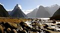
Milford Sound: Mitre Peak, the mountain on the left, rises 1692 m above the fiord
-
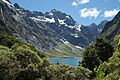
Lake Marian in the Darran Mountains
-
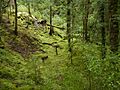
Understory with shrubs, ferns and mosses
-
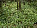
Crown ferns
-
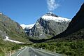
Milford Road east of Homer Pass
.jpg)

.JPG)
.JPG)

See also
 In Spanish: Parque nacional de Fiordland para niños
