Secretary Island facts for kids
|
Native name:
Ka Tū-waewae-o-Tū
|
|
|---|---|

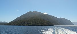
Secretary Island's eastern end
|
|
| Geography | |
| Location | Fiordland |
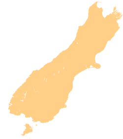
| Coordinates | 45°15′S 166°55′E / 45.250°S 166.917°E |
| Area | 81.4 km2 (31.4 sq mi) |
| Highest elevation | 1,196 m (3,924 ft) |
| Highest point | Mount Grono |
| Administration | |
| Demographics | |
| Population | 0 |
Secretary Island (which in Māori is called Ka Tū-waewae-o-Tū) is a special island in the southwest of New Zealand. It is completely inside Fiordland National Park. The island is shaped a bit like a triangle.
It sits between two sounds: Doubtful Sound / Patea to the south and Te Awa-o-Tū / Thompson Sound to the north. Its western side faces the big Tasman Sea. On the eastern side, a waterway called Pendulo Reach connects Thompson Sound and Doubtful Sound.
Secretary Island is very steep and covered in thick forest. It has several peaks over 1,000 metres high. The tallest is Mount Grono, which is 1,196 metres high. This makes it the highest peak in New Zealand's main island chain that isn't on the North or South Island. The island also has three lakes. The biggest one, Secretary Lake, is over 600 metres long and sits near Mount Grono at 550 metres above sea level.
No one lives on Secretary Island. It covers about 81.4 square kilometres of mostly steep land. This land is almost entirely covered in thick native forest, including special plants like mistletoes and mountain lancewood. These plants have been badly damaged in other places by animals like possums.
Because it's so isolated and large, Secretary Island is super important for protecting New Zealand's rare native animals and plants. The island never had possums or rats. By 2007, deer and stoats were also removed. This makes it the biggest island in New Zealand that is completely free of pests!
With the deer gone, the island's natural environment is doing really well. Plants from tiny ground covers to tall trees support many native animals, from insects and spiders to native birds. Endangered birds that have been moved here are recovering because there are no rats or mice to bother them.
Contents
Protecting Native Animals: Pest Eradication
Between 2004 and 2008, the New Zealand Department of Conservation worked on a big project to get rid of pests from Secretary Island. This was done to help protect the native animals and plants living there. It was the largest island in Fiordland to be made pest-free. The goal was to remove deer and stoats, which were the only animal pests left on the island at that time.
Removing Deer from the Island
In 2006, there were more than 700 deer on Secretary Island. The project worked hard to reduce their numbers. Getting rid of the deer helps the native plants grow back. These plants then support the endangered native animals on the island. This is a natural way to help the island's ecosystem heal.
Getting Rid of Stoats
Since 2004, a network of stoat traps has been set up across the island. These traps are connected by walking paths through the forest. Removing stoats is very important for protecting native birds already on the island. These include the Fiordland crested penguin, New Zealand falcon, kākā, kiwi, and kākāriki. Making the island a stoat-free safe place could also allow other animals to be brought back. These include the Fiordland skink and the kākāpō, which are no longer found on the mainland.
Helping Endangered Native Animals Recover
Because there are no rats or mice, many native insects and other small creatures can live and grow. This includes the very rare knobbled weevil.
Rock Wren Relocation
In 2008, 25 New Zealand rock wrens were moved to Secretary Island. The results were excellent! Two years later, rangers found 12 young rock wrens that had not been tagged. This showed that the birds started breeding soon after they were moved. Sixteen more birds were moved in 2010. Secretary Island is a great home for these birds because it is in the south and has many high areas over 1,000 metres. These are the harsh, high-up places that rock wrens like. On the mainland, rock wrens are in danger from introduced predators.
Other Bird Relocations
In 2008, 27 North Island kōkako were also moved to Secretary Island.
One of the biggest moves was bringing up to 60 yellowheads (mohua) to the island. These rare birds were caught in the Dart Valley and flown to Secretary Island. This helped create a new group of these birds in a place free of rats. Enough birds were moved to make sure they have good genetic variety.
Other native birds moved to the island after stoats were removed include the South Island robin in 2008 and the takahē in 2009.
Secretary Island is also the only place where a special New Zealand moth, Sabatinca pluvialis, is known to live.
Visiting Secretary Island
Secretary Island might become an "Open Sanctuary" under the Fiordland National Park plan. This means it would be protected, but people could still visit it. However, the island might be closed sometimes when they are working to control stoats and deer.
Just like with all of New Zealand's special conservation islands, visitors must be very careful. You need to make sure you don't accidentally bring any unwanted plants or animal pests onto Secretary Island. Check your clothes, bags, and equipment carefully.
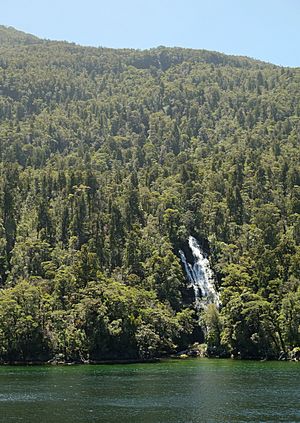
Blanket Bay is on the southeast coast of the island. It has a small island with a wharf and a hut. Fishermen use this for refuelling and supplies. A waterfall that drops from Secretary Island into the bay has been used in the past as a source of fresh water.
Secretary Island is separated from Bauza Island by the Te Awaatu Channel. This channel is only 200 metres wide at its narrowest point. The waters between the two islands are protected by the Te Awaatu Channel (The Gut) Marine Reserve. Tour boats from Doubtful Sound often travel through this channel. This gives people an easy way to see this remote island up close.
A radio repeater is located on Mount Grono, the highest point on the island. This helps boat operators in the Fiordland area communicate.
Earthquakes Near Secretary Island
In 1993, Secretary Island was the centre of a strong earthquake. It was so strong that people in Sydney, Australia, reportedly felt it! Ten years later, in 2003, another earthquake happened near Secretary Island.
Climate on Secretary Island
| Climate data for Secretary Island (1991–2020) | |||||||||||||
|---|---|---|---|---|---|---|---|---|---|---|---|---|---|
| Month | Jan | Feb | Mar | Apr | May | Jun | Jul | Aug | Sep | Oct | Nov | Dec | Year |
| Mean daily maximum °C (°F) | 18.0 (64.4) |
18.3 (64.9) |
17.2 (63.0) |
15.6 (60.1) |
13.7 (56.7) |
12.2 (54.0) |
11.8 (53.2) |
12.2 (54.0) |
12.9 (55.2) |
13.8 (56.8) |
14.8 (58.6) |
16.7 (62.1) |
14.8 (58.6) |
| Daily mean °C (°F) | 14.8 (58.6) |
15.1 (59.2) |
14.1 (57.4) |
12.8 (55.0) |
11.2 (52.2) |
9.6 (49.3) |
9.1 (48.4) |
9.5 (49.1) |
10.2 (50.4) |
10.8 (51.4) |
11.8 (53.2) |
13.5 (56.3) |
11.9 (53.4) |
| Mean daily minimum °C (°F) | 11.6 (52.9) |
11.9 (53.4) |
11.1 (52.0) |
9.9 (49.8) |
8.7 (47.7) |
7.0 (44.6) |
6.5 (43.7) |
6.7 (44.1) |
7.4 (45.3) |
7.9 (46.2) |
8.7 (47.7) |
10.4 (50.7) |
9.0 (48.2) |
| Average rainfall mm (inches) | 364.1 (14.33) |
280.2 (11.03) |
351.5 (13.84) |
318.7 (12.55) |
380.8 (14.99) |
297.2 (11.70) |
255.8 (10.07) |
258.0 (10.16) |
314.8 (12.39) |
370.4 (14.58) |
322.6 (12.70) |
365.3 (14.38) |
3,879.4 (152.72) |
| Source: NIWA | |||||||||||||
 | Victor J. Glover |
 | Yvonne Cagle |
 | Jeanette Epps |
 | Bernard A. Harris Jr. |


