
Routeburn Track facts for kids
Quick facts for kids Routeburn Track |
|
|---|---|

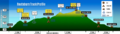
Key Summit as viewed from track
|
|
| Length | 32 km (20 mi) |
| Location | Fiordland National Park & Mount Aspiring National Park, New Zealand |
| Designation | New Zealand Great Walk |
| Trailheads | Routeburn Shelter, The Divide |
| Use | Tramping, Trail running |
| Highest point | near Harris Saddle 1,300 m (4,300 ft) |
| Lowest point | Routeburn Shelter, 477 m (1,565 ft) |
| Difficulty | medium |
| Season | Summer to autumn |
| Months | Late October to late April. Possible to walk in winter months too, but for experienced hikers only |
| Sights | Alpine views, lakes, forests, tussocklands, rivers, waterfalls |
| Hazards | Hypothermia, sunburn, high winds, rocks, snow, rain & avalanche risks |
| Surface | dirt, rock |
| Website | Department of Conservation |
The Routeburn Track is a very famous 32-kilometer (20-mile) hiking trail in the South Island of New Zealand. It's known all over the world for its amazing views. You can start the hike from either the Queenstown side, near Lake Wakatipu, or the Te Anau side, close to Milford Sound.
New Zealand's Department of Conservation calls this trail a Great Walk. This means it's one of the best and most well-kept trails in the country. There are four huts along the track where hikers can stay overnight. These are Routeburn Flats Hut, Routeburn Falls Hut, Lake Mackenzie Hut, and Lake Howden Hut. There's also an emergency shelter at Harris Saddle.
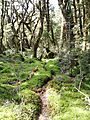
The track goes through two beautiful national parks: Mount Aspiring National Park and Fiordland National Park. The highest point on the track, Harris Saddle, is right on the border between these two parks. The area around the Routeburn Track gets less rain than Milford Sound. This means the forests are different, with lots of beech trees and fewer ferns, especially on the eastern side. The trail often follows high ridges, giving you incredible long-distance views. People have been using this track since the 1880s.
Contents
Hiking the Routeburn Track
It's a good idea to plan your trip on the Routeburn Track. During busy times, you need to book your spot in the huts or camping areas ahead of time. You can choose which way to walk the track and which huts to stay in. Most hikers stay at Lake Mackenzie Hut on the western side. On the eastern side, you can choose between Routeburn Falls Hut or Routeburn Flats Hut. Many people prefer Falls Hut because it helps break up the climb to Harris Saddle. Camping is not allowed at Falls Hut.
Day Trips and Shorter Hikes
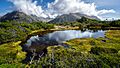
Even if you don't want to hike the whole track, parts of it are great for day trips. Key Summit (918 meters or 3,012 feet) is a popular spot on the western end. It has a fantastic viewpoint and a short nature walk that's easy to reach from the road. Walking to Routeburn Flats Hut and back is another popular day hike.
Getting to the Track
Since the track starts and ends in different places, getting around can be tricky. The two ends of the track are about 340 kilometers (211 miles) apart by road. This is about a 5-hour drive. You can use a bus, try hitchhiking, or arrange for your car to be moved to the other end. Some hikers even do a "key swap" with other hikers going the opposite way!
The Route: What You'll See
The Routeburn Track takes you through many different landscapes. Here's a look at what you'll experience along the way.
Starting from Routeburn Shelter
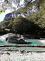
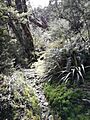
The trail begins at the Routeburn Road end. You'll cross a suspension bridge and then walk gently alongside the Routeburn River. The path is well-made and takes you past Sugarloaf Stream and the beautiful Bridal Veil waterfall. The track then climbs a bit higher above a gorge to Forge Flats, which used to be a blacksmith's camp long ago. After this, the valley opens up, and you'll cross the Routeburn River again before reaching the Routeburn Flats.
Climbing to Routeburn Falls Hut
From Routeburn Flats Hut, the track climbs steadily. You'll pass Eagle Bluff and Emily Creek. You'll also cross an area where a big landslide happened in 1994. This landslide cleared away some trees, giving you amazing views back down the Routeburn valley and up towards Mount Somnus (2293m) and Mount Momus (2148m).
Around Lake Harris and Harris Saddle
After Routeburn Falls Hut, the track gets a bit narrower and more challenging. It climbs past Lake Harris, going under rocky cliffs. You'll see a view up "the valley of trolls" towards Lake Wilson, which is where the Routeburn River starts. Above Lake Harris, you'll reach the Harris Shelter.
Harris Saddle and Beyond
From Harris Saddle (1255m), the track goes south along the Hollyford face. You'll get huge views all the way out to Martins Bay and the Tasman Sea. Then, the path goes steeply downhill in zig-zags to Lake Mackenzie Hut.
From Lake Mackenzie to The Divide
From Lake Mackenzie, the track crosses a small flat area before climbing up to the tree line. It then slowly goes downhill past a grassy area called the 'Orchard,' which has ribbonwood trees. You'll reach Earland Falls, which is 174 meters (571 feet) high. The path usually goes right under the falls, but if there's a lot of water, there's another route that goes below the falls to a small bridge.
The track continues to go downhill to Howden Hut. From here, you can take a side path towards the Greenstone and Caples Tracks. These tracks form a loop back towards Glenorchy. The main Routeburn Track continues past Key Summit to The Divide road end, which is the end of the trail.
Side Trips to Explore
There are many interesting side trips you can take off the main Routeburn Track. Some hikers add these to their full journey, while others use the main track to reach these extra adventures.
Nature Walk
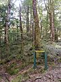
Near the Routeburn Shelter, there's a short loop track with signs. It's great for day walkers who want to learn about the area's plants and animals.
Conical Hill
From the Harris Shelter, a steep path takes you to the top of Conical Hill (1515m). This is the highest marked trail on the Routeburn Track. From the top, you get a wide, 360-degree view of the whole area.
Key Summit
This is the most popular side trip. It's a day walk that starts from The Divide. The track continues beyond the main viewpoint, becoming an unmarked route along the Livingstone Mountains.
Huts and Shelters Along the Way
{{gallery mode="packed" heights="100px" Image:Routeburn_Shelter.jpg|Routeburn Shelter Image:Routeburn Flats Hut 1.jpg|Routeburn Flats Hut Image:RouteburnFallsHut.jpg|Routeburn Falls Hut Image:Harris_Saddle_Shelter_closeup.jpg|Harris Saddle Shelter Image:Lake Mackenzie Hut.jpg|Lake Mackenzie Hut Image:Howden Hut Routeburn Track.jpg|Lake Howden Hut Image:The Divide (shelter).jpg|The Divide Shelter }}
Birdlife on the Track
You can see many native New Zealand birds while hiking the Routeburn Track.
- Parrots: Keep an eye out for the kaka and kea. These are large parrots. You might also spot the smaller yellow-crowned parakeet.
- Friendly Birds: The common and friendly South Island robin and fantail are often seen.
- Smaller Birds: Listen for the bellbird, grey warbler, brown creeper, and South Island tomtit. The rare yellowhead is also here.
- Tiny Birds: The tiny rifleman and New Zealand's smallest bird, the Rock Wren, are harder to spot.
{{gallery mode="packed" heights="100px" Image:SI-Tomtit2-Routeburn.jpg|South Island tomtit Image:Yellow-crowned-Parakeet-Routeburn.jpg|Yellow-crowned parakeet Image:Yellowhead-Routeburn.jpg|Yellowhead / mohua Image:Nestor meridionalis -Routeburn Track, Fiordland, New Zealand-8d.jpg|South Island kākā }}
Images for kids
-
Routeburn Track Profile
-
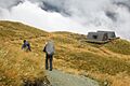
Routeburn Track emergency shelters at Harris Saddle
-
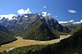
View of the Humboldt Mountains from the track
-
Forge Flat
-
Sugarloaf and Rockburn Tracks
-
Deadmans Track
-
Pass Creek Track
-
Key Summit
-
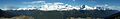
Panoramic mountain view from the Routeburn Track


.jpeg)
