Kepler Track facts for kids
Quick facts for kids Kepler Track |
|
|---|---|

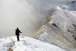
An alpine section of the Kepler Track
|
|
| Length | 60 km (37 mi) |
| Location | Fiordland National Park, Southland, New Zealand |
| Designation | New Zealand Great Walk |
| Trailheads | Lake Te Anau control gates, Rainbow Reach, Brod Bay |
| Use | Hiking, running |
| Highest point | Luxmore Saddle 1,400 m (4,600 ft) |
| Lowest point | Lake Manapouri, 178 m (584 ft) |
| Difficulty | medium |
| Season | Summer to Autumn |
| Months | Late October to mid April Possible to walk in winter months too, but for experienced hikers only |
| Sights | Ridgetop alpine views, lakes, wetlands, forests, rivers, waterfalls |
| Hazards | Hypothermia, sunburn, high winds |
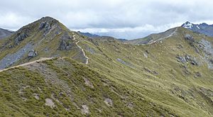
The Kepler Track is a 60 km (37 mi) long circular walking path in the South Island of New Zealand. It is located near the town of Te Anau. This amazing track takes you through many different landscapes of the Fiordland National Park. You will see rocky mountain ridges, tall mossy forests, calm lake shores, deep gorges, and beautiful rivers.
The track is named after Johannes Kepler, a famous scientist from the 1600s. It is one of New Zealand's special "Great Walks." The Department of Conservation (DOC) looks after the track.
The Kepler Track is built to a very high standard. Most streams have bridges, and wet areas have wooden walkways. Even very steep parts have steps to make walking easier. It is a moderate walk that usually takes three to four days to finish.
Every year, the Kepler Track hosts the Kepler Challenge. This is a running race where people run the entire 60 kilometres (37 mi) track. The fastest runners can finish it in less than five hours!
| Top - 0-9 A B C D E F G H I J K L M N O P Q R S T U V W X Y Z |
History of the Kepler Track
Ancient Stories and Names
Long ago, the Māori people had a legend about Rākaihautū. He was a famous leader who explored the South Island. During a rainy time, his group found a large, beautiful lake. They called it Te Ana Au, which means "cave of rain." Just south of it, they found another lake. Rākaihautū named it Roto Ua, meaning "the lake where rain is constant." Today, we know Roto Ua as Lake Manapouri. The Kepler Track is located between these two lakes.
Later, Richard Henry, Fiordland's first park ranger, explored the Kepler area often. A man named James McKerrow later named the mountains after Johannes Kepler, the German astronomer. Early paths on Mount Luxmore were made by Jack Beer. He used them to take his sheep to graze in the summer.
Creating a Great Walk
Many walking paths in New Zealand started as Māori trails. Others came from early explorers. The idea for the Kepler Track came from Alf Excell and Les Henderson. In 1984, New Zealand's National Parks were planning a big celebration for their 100th birthday. They asked for ideas for new projects.
Alf Excell and Les Henderson, who were part of the Fiordland National Park Board, suggested a path they called the "Around the Mountain Walk." This new track would connect existing paths. It would go from the Te Anau Lake control structure to the Luxmore Mountain Meadows. Then it would go down to the Iris Burn Valley and along Lake Manapouri. Finally, it would connect back to the Te Anau Control Structure.
This project was approved. The Kepler Track was officially opened in February 1988. It became a "Great Walk" as part of the Fiordland National Park's 100th birthday celebrations. It was also designed to help reduce the number of people on other popular tracks like the Milford and Routeburn Tracks.
A group called the International Expedition Operation Raleigh helped a lot. In 1986 and 1987, explorers from all over the world helped build many of the walkways. They also built the Iris Burn and Mount Luxmore huts.
Walking the Kepler Track
Most people walk the Kepler Track starting from the Lake Te Anau Control Gates. You can walk it in either direction. If you don't have much time, you can shorten the track to three days. You can start or finish at the Rainbow Reach swing bridge. You can get there by car or bus.
While you can camp on the Kepler Track, it means a very long walk between some campsites. A much easier way is to stay in the huts. Many people stay at Luxmore Hut on the first night. Then they go to Iris Burn Hut or campsite for the second night. They finish the track to Rainbow Reach on day three. You can watch a helpful video about the Kepler Track from the New Zealand Mountain Safety Council here: Kepler Track Safety Video.
The cost and availability of places to stay change a lot. It's more expensive and harder to book during the busy summer season.
Typical Walks on the Kepler Track
Here are some common ways to walk the Kepler Track:
Four-Day Walk
- Day 1: Lake Te Anau Control Gates to Luxmore Hut
- Distance: 13.8 km (8.6 mi)
- Time: 5 to 6 hours
- Description: The path follows the shores of Lake Te Anau through a beech forest. You'll pass Brod Bay, where you can camp or take a boat shuttle. The track then climbs past limestone cliffs to Luxmore Hut. Near the hut, you can explore a cave.
- Day 2: Luxmore Hut to Iris Burn Hut
- Distance: 14.6 km (9.1 mi)
- Time: 5 to 6 hours
- Description: This day includes a gradual climb to Luxmore Saddle, the highest point on the main trail. From here, you get amazing views of the park. You can even climb to the peak of Mount Luxmore for a 360-degree view of Lake Te Anau. The path then follows a long ridge and goes down into the Iris Burn Valley. You'll walk through a forest and see a large natural landslide. Iris Burn Hut is in a grassy clearing.
- Day 3: Iris Burn Hut to Moturau Hut
- Distance: 16.2 km (10.1 mi)
- Time: 5 to 6 hours
- Description: The track goes over a small hill and through a mixed forest. You'll pass a large slip (landslide) from heavy rain in 1984. The path then goes through a gorge and out onto river flats near the Iris Burn. It follows the lake shore to Moturau Hut, which is next to a beach with views of Lake Manapouri.
- Day 4: Moturau Hut to Lake Te Anau Control Gates
- Distance: 15.5 km (9.6 mi)
- Time: 4 to 5.5 hours
- Description: This section crosses many small streams. It runs next to the Waiau River until you reach the Rainbow Reach swing bridge. From there, the path goes through a mixed forest, crossing more small streams, and finally arrives back at the Control Gates.
Three-Day Walk
- Day 1: Lake Te Anau Control Gates to Luxmore Hut
- Same as Day 1 of the four-day walk.
- Day 2: Luxmore Hut to Iris Burn Hut
- Same as Day 2 of the four-day walk.
- Day 3: Iris Burn Hut to Rainbow Reach Swing Bridge
- Distance: 22.2 km (13.8 mi)
- Time: 6.5 to 8 hours
- Description: This is a longer day. You follow the track from Iris Burn Hut to Moturau Hut (as in the four-day walk). Then, from Moturau Hut, you continue for another 6 km (3.7 mi) to the Rainbow Reach swing bridge. This last part crosses many small streams and runs next to the Waiau River.
The Lake Te Anau Control Gates are about 4.6 kilometres (2.9 mi) from the DOC visitors centre in Te Anau.
Location and Access
The Kepler Track is in the southwest of New Zealand's South Island. The closest towns are Te Anau (about 4.6 km (2.9 mi) away) and Manapouri. These towns have places to stay and shops where you can buy everything you need for your hike.
You can get to the Kepler Track from the Lake Te Anau Control Gates. You can drive there, or it's a 50-minute walk from the Fiordland National Park Visitor Centre in Te Anau. Another way to start is from the swingbridge across the Waiau River at Rainbow Reach. This is about a ten-minute (12 km (7.5 mi)) drive from Te Anau.
During the summer, shuttle buses run to the start and end points of the track. There is also a boat service that can take you to Brod Bay.
Huts and Campsites
The Kepler Track has several huts and campsites where hikers can stay overnight. Like most of New Zealand's Great Walks, you usually need to book huts through the Department Of Conservation (DOC) New Zealand in advance. Remember, there are no showers or rubbish collection services on the track. It's a good idea to bring bug spray in summer, as sand flies can be very common!
Along the trail, there are also shelters. You can use these for daytime picnics and rest stops. A few are set up for emergencies during the winter months.
Brod Bay Campsite
This campsite is located right on Lake Te Anau. It's the first campsite for hikers who start their journey from the control gates.
Luxmore Hut
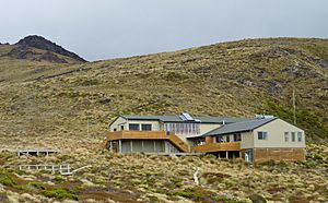
This hut can sleep 54 people in bunk beds with mattresses. It has stoves and tables inside for cooking. There's also an outside deck area. It has a large bunk room and a smaller one that looks out over Lake Te Anau. You are not allowed to camp at this specific hut site. The Luxmore Caves, which are a large system of caves, are nearby.
Iris Burn Hut
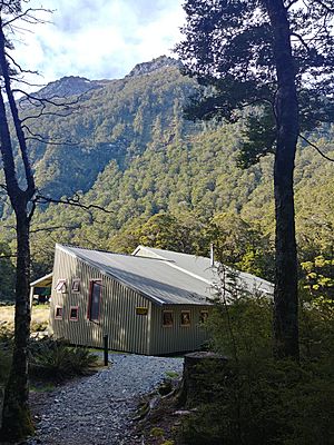
This hut can sleep 50 people in three separate bunk rooms with mattresses. It has the same facilities as the Luxmore Hut. The hut is in a small field near a small river. About a 20-minute walk from the hut is the Iris Burn Waterfall, where you can even go for a swim!
Iris Burn Campsite
There are several campsites in the shaded area under the trees near the Iris Burn Hut and by the stream. It's a good idea not to camp in the open field. This is because Kea birds (forest parrots) are known to bother tents that are set up in the field.
Moturau Hut
This hut is located on Lake Manapouri. It sleeps 40 people in bunk beds with mattresses. In summer, you can go swimming in the lake. There are also outdoor picnic tables to enjoy the views.
|
See also
 In Spanish: Montañas Kepler para niños
 | William M. Jackson |
 | Juan E. Gilbert |
 | Neil deGrasse Tyson |


