
Milford Track facts for kids
Quick facts for kids Milford Track |
|
|---|---|

Trampers on part of Milford Track
|
|
| Length | 53.5 km (33.2 mi) |
| Location | Fiordland National Park, Southland, New Zealand |
| Designation | New Zealand Great Walk |
| Trailheads | Glade Wharf in Lake Te Anau, Sandfly Point in Milford Sound |
| Use | Hiking |
| Highest point | Mackinnon Pass, 1,140 m (3,740 ft) |
| Lowest point | Sandfly Point, 0 m (0 ft) |
| Difficulty | Medium |
| Season | Summer to Autumn |
| Months | Late October to late April |
| Sights | See below |
| Hazards | Hypothermia, sunburn, high winds, flooding, sandflies, avalanches |
The Milford Track is an amazing hiking trail in New Zealand. It's found in the beautiful Fiordland National Park, surrounded by tall mountains and lush rainforest. This famous track is 53.5 kilometers (about 33 miles) long. It starts at Glade Wharf on Lake Te Anau and ends at Sandfly Point in Milford Sound. Along the way, you'll walk through dense rainforests, across wetlands, and over a high mountain pass.

The New Zealand Department of Conservation calls the Milford Track a "Great Walk." They look after three main huts along the way: Clinton Hut, Mintaro Hut, and Dumpling Hut. There are also three private lodges and four day shelters. Most people take about three days to hike the trail, walking 15 to 20 hours in total. This doesn't include the boat ride to the first hut. Some super-fast hikers can even run the whole track in one day! The quickest known time was by Brian Culmo, who finished in just 6 hours and 55 minutes.
Contents
History of the Milford Track
Early Māori Explorers
Long ago, the native Māori people knew this area well. They used it to find and carry valuable greenstone, called pounamu. The Māori have many old stories and legends about the land and the special plants and animals found here.
European Discoveries
In 1880, two European explorers, Donald Sutherland and John Mackay, explored the Milford end of the track. They were the first Europeans to see the beautiful Mackay Falls and Sutherland Falls. Later, in 1888, Quintin McKinnon and a friend set out from Lake Te Anau. They wanted to find a way to reach Milford Sound by land. They discovered what is now known as Mackinnon Pass, a high mountain pass. This discovery helped them connect with Sutherland on the other side.
The First Guides
Quintin McKinnon became the very first guide to lead walkers from Lake Te Anau to Milford Sound. He started by guiding tours himself and then helped make the track famous. Many places on the Milford Track are named after him, like Mackinnon Pass, which is the highest point on the trail. He also cooked a type of scone called "pompolona," which gave its name to one of the guided trip huts.
For a long time, only guided tours were allowed on the Milford Track. But in 1965, a group of 46 hikers from the Otago Tramping Club did a "freedom walk." This helped change the rules. In 1966, the track opened up for both guided and independent walkers. New huts and facilities were built for people who wanted to walk on their own. Today, about half the spots on the track are for guided tours, and the other half are for independent walkers. Each group uses different huts.
How to Access the Track
The Milford Track is a bit special because you can't just drive to the start. You need to take a boat! To begin your hike, you'll take a boat from Te Anau Downs to Glade House, which is the southern start of the track. At the very end of the track, at Sandfly Point, you'll need another boat to take you back to Milford Sound. There is a very difficult hiking route called the Dore Pass Route that leads to the start, but it's not recommended for most walkers.
Hiking in Summer
Peak Season Rules
The best time to hike the Milford Track is during the summer peak season, from late October to late April. During this time, access to the trail is very controlled. Hikers must finish the track in four days and can only walk in one direction (northward). You are not allowed to camp on the trail.
Each day, a maximum of 90 walkers can start the trail. 40 spots are for independent hikers, and 50 are for guided tours. These spots are usually booked many months in advance because the track is so popular!
Independent Hiking
If you choose to hike independently, you'll stay in huts owned by the New Zealand Department of Conservation. These huts are basic but have bunk beds, restrooms, and cooking areas. You'll need to carry all your own gear and food.
Guided Hiking
If you go on a guided walk, you'll stay in special lodges. These lodges offer more comforts like hot showers and meals. Guided hikers only need to carry their clothes, toiletries, sheets, and lunch for the day. The main company that runs guided multi-day walks on the Milford Track is Ultimate Hikes.
Hiking in the Off-Season
From May to mid-October, it's the off-season. During this time, the track is much less regulated. You can hike in either direction and take as many days as you like. However, hiking in the off-season is much harder and more dangerous. Some hut facilities are removed, and up to 10 bridges are taken down to prevent damage from avalanches.
Huts and Lodges on the Track
There are different places to stay along the Milford Track, depending on whether you are hiking independently or with a guided tour.
| Name | Description | Distance | Coordinates |
|---|---|---|---|
| DOC Huts (for independent walkers) | |||
| Clinton Hut | Your first night's stop, located shortly after the marsh boardwalk. | 5.0 km | 44°54′18.23″S 167°54′6.63″E / 44.9050639°S 167.9018417°E |
| Mintaro Hut | Your second night's stop, just before the climb up to Mackinnon Pass. | 21.5 km | 44°48′37.61″S 167°46′34.84″E / 44.8104472°S 167.7763444°E |
| Dumpling Hut | Your third night's stop, a few kilometers after Quintin Lodge. | 35.5 km | 44°46′07.18″S 167°45′56.35″E / 44.7686611°S 167.7656528°E |
| Private Lodges (for guided walkers) | |||
| Glade House | Your first night's stop, very close to the start of the track. | 1.6 km | 44°55′18″S 167°55′43″E / 44.921797°S 167.928721°E |
| Pompolona Lodge | Your second night's stop, in a forested part of the Clinton Canyon. | 17.5 km | 44°50′15″S 167°48′03″E / 44.837485°S 167.80094°E |
| Quintin Lodge | Your third night's stop, near the turnoff to Sutherland Falls. | 32.5 km | 44°47′29″S 167°45′11″E / 44.791348°S 167.752985°E |
| Day Use Shelters | |||
| Hirere Shelter | A place to rest, just after Clinton Forks. | 44°52′12.48″S 167°50′32.13″E / 44.8701333°S 167.8422583°E | |
| Bus Stop Shelter | A rest stop, just before Pompolona Lodge. | 44°50′25.73″S 167°48′16.08″E / 44.8404806°S 167.8044667°E | |
| Pass Hut | Located right at the top of Mackinnon Pass. | 44°48′11.58″S 167°46′33.55″E / 44.8032167°S 167.7759861°E | |
| Boatshed Hut | A shelter just before Mackay Falls. | 44°44′20.33″S 167°48′11.18″E / 44.7389806°S 167.8031056°E | |
Amazing Sights on the Track
The Milford Track is famous for its incredible natural beauty. Here are some of the amazing sights you can see:
| Name | Description | Location |
|---|---|---|
| Mackinnon Pass | A stunning mountain pass surrounded by mountains covered in glaciers. | 44°48′5″S 167°45′59″E / 44.80139°S 167.76639°E |
| Sutherland Falls | New Zealand's tallest waterfall, dropping 580 meters (1,900 feet)! It's always flowing from Quill Lake. | 44°48′1″S 167°43′49″E / 44.80028°S 167.73028°E |
| Nicholas Cirque | A ring of mountains shaped by glaciers at the head of the valley. | 44°48′0″S 167°45′0″E / 44.80000°S 167.75000°E |
| Mackay Falls & Bell Rock | Bell Rock is a huge rock that was hollowed out by Mackay Falls and then flipped upside down. You can stand inside the hollow part, which is over 4 meters (13 feet) high! | 44°43′52″S 167°47′25″E / 44.73111°S 167.79028°E |
| Giant Gate Falls | The last big waterfall you'll see on the track if you're heading north. | 44°42′14″S 167°51′9″E / 44.70389°S 167.85250°E |
| Lake Ada | A lake that was formed when a landslide blocked the Arthur River. | 44°42′31″S 167°51′28″E / 44.70861°S 167.85778°E |
| Milford Sound | World-famous for its dramatic, steep cliffs that rise straight out of the mirror-like water. | 44°36′55″S 167°51′44″E / 44.61528°S 167.86222°E |
| Lake Te Anau | This huge lake was carved out by glaciers. It's the second-largest freshwater lake in New Zealand and is surrounded by mountains. | 44°56′24″S 167°54′44″E / 44.94000°S 167.91222°E |
Images for kids
-
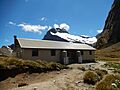
The shelter hut on Mackinnon Pass.
-
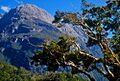
Sheerdown Peak near the end of the Milford Track.
-
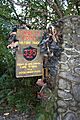
Abandoned hiking boots at the sign announcing the finish of the track.


