
Hump Ridge Track facts for kids
Quick facts for kids Tuatapere Humpridge Track |
|
|---|---|

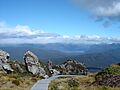
Boardwalk on the track up near Okaka hut, looking out to Lake Poteriteri
|
|
| Length | 61 km (38 mi) |
| Location | Fiordland National Park, New Zealand |
| Established | 2001 |
| Trailheads | Rarakau Carpark |
| Use | Tramping |
| Highest point | Loop track above Okaka Lodge 978 m (3,209 ft) |
| Lowest point | Sea level, 4 m (13 ft) |
| Difficulty | hard/medium |
| Season | Summer to autumn |
| Months | October to April. Can be walked in winter months too, but Tuatapere Office is closed |
| Sights | Viaducts, alpine views, beaches, forests, tussocklands, Foveaux Strait, historic relics |
| Hazards | Tree roots, hypothermia, sunburn, high winds, rocks, snow & rain |
| Surface | dirt, rock, sand, tree roots, railway sleepers, boardwalk |
| Website | Tuatapere Hump Ridge Track website |

The Hump Ridge Track is an amazing walking trail in the south-east part of Fiordland National Park. This park is located in the South Island of New Zealand. The track is about 61 kilometers long and goes through the beautiful Waitutu Forest.
Around 1,800 people walk this track every year. The closest town is Tuatapere. Many people stay in Te Anau and drive to the track in the morning. The Hump Ridge Track opened in November 2001. Part of the track crosses land owned by Māori people and other private land.
The Tuatapere Hump Track Trust looks after two lodges and over 20 kilometers of boardwalk. The Department of Conservation (DOC) takes care of the coastal part of the track. They also maintain the old school hut at Port Craig.

Contents
Exploring the Hump Ridge Track Route
The Hump Ridge Track begins at the Rarakau Farm car park, near Bluecliffs Beach. Most people walk the track in an anti-clockwise direction. This means your first night is spent at Okaka Lodge. This lodge is high up on the hump ridge, over 900 meters above sea level.
From Okaka Lodge, you get amazing views of Fiordland and the sea. You can even see Stewart Island and other small islands. The track crosses three huge old bridges called viaducts. One of them is the impressive Percy Burn Viaduct. There's a fourth viaduct you can see, but you can't walk on it.
Your second night is spent at the coastal Port Craig Village. From here, you can easily walk to the lovely Mussel Beach. On the third day, you walk back to the start. You'll go through native bush, then along Blowholes Beaches and Bluecliffs Beach. Finally, you'll arrive back at the car park.
Each day, you'll need to walk for about six to nine hours. The first day involves a big climb of 900 meters to the top of the ridge. The second day is mostly downhill, but it can still feel quite long.
How Long is the Hump Ridge Track?
The Department of Conservation says the track is about 61 kilometers long. However, some people have measured it between 55 and 63 kilometers. The exact length can change for a few reasons.
Sometimes, you can choose to walk on the beach, the main track, or a four-wheel drive track. This can make the distance different. The path also goes up and down mountains, through trees, and over roots. This means the distance you walk can vary. Mapping the track on a flat map doesn't show its true length because of all the ups and downs. There are also side routes, like a loop above Okaka Lodge or the beach at Port Craig. These will add to your total walking distance. Plus, there's an extra 300 meters from the car park to the actual start of the track.
Track Surface and Terrain
Most of the track along the coast is flat and easy to walk on. The surface is made of sand or dirt. However, it can get very muddy near the viaducts between Port Craig and Edwin Burn. This area also has hundreds of old railway sleepers left over from logging days.
The sections that go up the hill are very delicate. Much of this part has boardwalks, which make walking easier. They also help protect the plants and ground. In places without boardwalks, you might find many trees, roots, and a lot of mud.

Stump the Hump Event
"Stump the Hump" is a special walking event held every year. People walk the entire Hump Ridge Track in the usual anti-clockwise direction. It started in 2011. Walkers begin early, at midnight on a Friday in February, using lights to guide them. Most people are expected to finish the track in less than 24 hours. Any money raised from this event helps with track maintenance.
Amazing Plants and Animals on the Track

Near the coast, you'll find thick forests of large trees. These include rimu, miro, Hall's totara, and rata. Lower down, the forests are mostly podocarp and silver beech trees. Higher up, you'll see yellow-silver pine trees.
Many different birds live here. You might spot the kaka, kea, yellow-crowned parakeet, and South Island robin. Other birds include the fantail, bellbird, grey warbler, and South Island tomtit.
If you're lucky, you might see Hector's dolphins swimming near Port Craig. Sometimes, people even get to swim with them!
History of the Hump Ridge Area

The Hump Ridge Track crosses three large viaducts. The biggest one, the Percy Burn Viaduct, is thought to be one of the largest wooden viaducts in the Southern Hemisphere. It's even mentioned in a book called Viaducts Against the Sky.
Long ago, Māori people visited the Waitutu area to find food. They would hunt and fish in the sea, rivers, and forests. They had camps along the Waiau River near Tuatapere. They used rafts called mokihi to cross the river. Tracks, probably very similar to today's track, led along the coast. These tracks helped them reach Sandhill Point, the Wairaurahiri River, and beyond.
In 1896, government workers first cut the coastal track. This was to provide a better way to reach gold mining towns like Cromarty and Te Oneroa. Before this, they relied on ships, which were not always reliable.
A telephone line was put in along the track in 1908. It connected the Puysegur Point Lighthouse to Orepuki. You can still find old insulators, wire, and huts used by maintenance workers today.
During the 1920s, Port Craig was home to the biggest and most modern sawmill in New Zealand. The Marlborough Timber Company mill employed over 200 men. They produced a huge amount of timber each month. Port Craig is full of history. The current DOC hut there used to be the old schoolhouse from the logging days.
Logs were brought to the mill using a high-quality tramway. This tramway ran from the forests to the west, between Port Craig and the Wairaurahiri River. Large viaducts were built from strong Australian wood to carry the tramlines over deep ravines. The Percy Burn Viaduct is the largest, at 125 meters long and 36 meters above the creek. It was fully repaired in 1994. The other viaducts were also fixed up in 1999.
Logging stopped in 1929. By then, about 14 square kilometers of forest had been cut down. The timber was shipped directly from Port Craig. Today, you can still see old wharf piles and building materials. The old Port Craig school has been turned into a hut for trampers (walkers).
Images for kids
-
Boardwalk on the track up near Okaka hut, looking out to Lake Poteriteri
