
Wilmot Pass facts for kids
Quick facts for kids Wilmot Pass |
|
|---|---|

Wilmot Pass as seen from Doubtful Sound
|
|
| Elevation | 671 m (2,201 ft) |
| Traversed by | Wilmot Pass Road |
| Location | Southland, South Island, New Zealand |
| Range | Matterhorn Mountains |
| Coordinates | 45°30′30″S 167°11′33″E / 45.50833°S 167.19250°E |

Location in New Zealand
|
|
The Wilmot Pass is a mountain pass in New Zealand's South Island. It stands 671 meters (about 2,200 feet) high. This pass connects Doubtful Sound, a deep inlet on the coast, to the valley of the West Arm of Lake Manapouri.
The pass is named after E. H. Wilmot. He was a surveyor who explored the area in 1897. Wilmot Pass is located between two mountains, Mount Wilmot and Mount Mainwaring. On the east side of the pass, the Spey River flows towards Lake Manapouri. On the west side, the Lyvia River flows to Deep Cove.
Contents
History of Wilmot Pass
Early Explorers
In 1888, a professor named Mainwaring-Brown was exploring the area west of Lake Manapouri. Sadly, he died during his exploration. Mount Mainwaring, a mountain near the pass, is named in his honor. R. Murrell was the first European to climb the pass. He did this in the same year while searching for Professor Mainwaring-Brown.
Surveying and Tourism
E. H. Wilmot, who later became New Zealand's Surveyor General, carefully mapped the area in 1897. During this time, paths were cut to both Doubtful Sound and Dusky Sound. Small huts were also built along these paths. However, over time, these paths and huts fell into disrepair.
In 1921, Leslie Murrell started a new tourism effort. He opened a lodge at Deep Cove. He also reopened the old walking track and led trips from Manapouri. Later, the Manapouri-Doubtful Sound Tourist Company took over. They built more huts to support the growing number of visitors.
The Wilmot Pass Road
Building the Road
The Wilmot Pass is crossed by a gravel road. This road was built to help with the construction of the Manapouri Hydroelectricity Project. This power station generates electricity using water. The road is special because it's the only road on New Zealand's mainland that isn't connected to the rest of the country's road network. Along the road, you can see several beautiful waterfalls, including the famous Stella Falls.
Before the 1960s, you could only reach Wilmot Pass by sea or by walking. The 21-kilometer (about 13-mile) gravel road was built between 1963 and 1965. It was needed to move very heavy equipment, sometimes weighing up to 97 tonnes (about 107 tons). This equipment was brought by ships to Doubtful Sound. From there, it was transported over the pass to build the underground Manapouri Power Station.
Current Use
Today, the Wilmot Pass road is still the only way to move very heavy equipment to and from the Manapouri Power Station. Equipment that is too heavy to be carried across Lake Manapouri must use this road.
Many tour companies now use this road for tourism. Tourists travel across Lake Manapouri by boat. Then, they take a bus over the Wilmot Pass. From there, they can enjoy boat or yacht cruises on Doubtful Sound. The buses used for these tours are kept at the Lake Manapouri end of the road.
Tunnels Under the Mountains
Two long tunnels, each about 10 kilometers (6 miles) long, connect Doubtful Sound with Lake Manapouri. These tunnels are deep under the mountains north of the pass. The first tunnel was finished in late 1969, just before the power station started working. The second tunnel was built later, between 1997 and 2002.
Images for kids
-
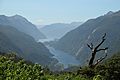
View from Wilmot Pass to Doubtful Sound
-
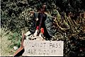
The old Pass marker
-
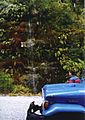
Lemin's moss garden on the Wilmot Pass Road, in the heart of Fiordland National Park


