
Lake Hauroko facts for kids
Quick facts for kids Lake Hauroko |
|
|---|---|
 |
|

Lake Hauroko
Location in South Island
|
|
| Location | Fiordland National Park, Southland District, Southland, South Island |
| Coordinates | 46°00′S 167°20′E / 46.000°S 167.333°E |
| Type | Glacial lake |
| Primary inflows | Caroline Burn, Hay River, Hauroko Burn, Russet Burn, Rooney River |
| Primary outflows | Wairaurahiri River |
| Catchment area | 195 sq mi (510 km2) |
| Basin countries | New Zealand |
| Max. length | 40 km (25 mi) |
| Surface area | 63 km2 (24 sq mi) |
| Max. depth | 462 m (1,516 ft) |
| Surface elevation | 150 m (490 ft) |
| Islands | Mary Island |
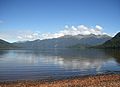
Lake Hauroko is the deepest lake in New Zealand. This amazing lake is 462 meters (about 1,516 feet) deep. You can find it hidden in a mountain valley inside Fiordland National Park.
Contents
What Does the Name Hauroko Mean?
The name "Hauroko" comes from te reo Māori, the language of the Māori people. It means "soughing of the wind" or "sounding wind." This describes the sounds the wind makes around the lake. Before the 1930s, some people also called it "Lake Hauroto."
Where is Lake Hauroko Located?
Lake Hauroko is shaped like an "S" and is about 20 miles (32 kilometers) long. Its surface covers an area of about 25 square miles (65 square kilometers). The lake's surface is about 155 meters (509 feet) above sea level.

This lake is one of New Zealand's southernmost lakes. It is only 13 kilometers (8 miles) from the southern coast of the South Island. Lake Hauroko sits between two other large lakes, Monowai and Poteriteri.
Water flows out of Lake Hauroko through the Wairaurahiri River. This river is about 20 kilometers (12 miles) long. It carries water into Foveaux Strait, which is about 10 kilometers (6 miles) west of Te Waewae Bay.
Islands in Lake Hauroko
The biggest island in Lake Hauroko is called Mary Island. It was named in 1883 after Mary, the wife of government surveyor John Hay. There is also a smaller island next to Teal Bay at the southern end of the lake. You can find a few other tiny islets and rocks scattered around the lake too.
How Lake Hauroko Was Formed
The Māori people have a traditional story about how the lake was made. They say that a great leader named Rākaihautū dug the lake. He did this on his journey south using his special digging tool called a ko. This story is part of the Ngāi Tahu Claims Settlement Act 1998.
Scientists, called geologists, have another explanation. They believe Lake Hauroko is a glacial lake. This means it was carved out by huge moving sheets of ice, called glaciers, a very long time ago. It formed near the Hauroko Fault, which is a crack in the Earth's crust.
The rocks around the lake are very old. Some are Hauroko granite, which is about 358 million years old. Other rocks include metamorphic rocks and younger sediments like sandstone.
Getting to Lake Hauroko
A road about 30 kilometers (19 miles) long connects Clifden to Lake Hauroko. This road was first built around 1909 and later improved in the 1960s.
If you want to explore further, you can take a water taxi across the lake. This taxi will take you to the start of the Dusky Track. This walking track begins at the north end of Lake Hauroko and leads all the way to Lake Manapouri.
The Lady of the Lake on Mary Island
Mary Island is known for a special discovery made in 1967. A burial site of a Māori woman was found in a cave on the eastern side of the island. Locals sometimes call her "the lady of the lake."
Experts believe this woman was buried sometime between the late 1500s and late 1600s, possibly around 1660. She was laid to rest sitting upright on a special platform made of sticks and leaves. She wore a cloak made of flax and a dog skin collar decorated with weka feathers.
Archaeological studies suggest she was a high-ranking leader, a chieftain of the Ngāti Moimoi tribe. The way she was buried might have been to protect her remains. Today, her burial site is still on the island. A steel and wire mesh grille protects it, allowing people to view the site respectfully without disturbing it.
Plants and Animals of Lake Hauroko
The forests around Lake Hauroko are home to many native trees. These include matai, totara, rimu, tawhai pango, tawhai, Pseudopanax linearis, and rautawhiri (Pittosporum Colensoi).
Lake Hauroko is special because it has not been taken over by many invasive water weeds. This means it still has rare native plants like Nitella stuartii algae, Callitriche petriei water-starwort, Isoetes kirkii quillwort, Pilularia novaezelandiae pillwort fern, Trithuria inconspicua waterlilies, and Charales fibrosa.
However, some animal pests have arrived in the area, like stoats and possums. These animals can harm native wildlife. To protect the local ecosystem, these pests are controlled using traps, bait stations, and sometimes special drops of a substance called 1080.
Images for kids
-
Lake Hauroko
See also
 In Spanish: Lago Hauroko para niños
