Gore District, New Zealand facts for kids
Quick facts for kids
Gore District
|
|
|---|---|
|
Territorial authority district
|
|

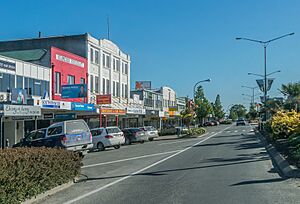
Main Street in Gore
|
|

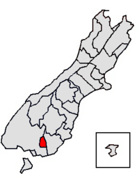
Location of the Gore District within the South Island
|
|
| Country | New Zealand |
| Region | Southland |
| Wards |
|
| Formed | 1989 |
| Seat | Gore |
| Area | |
| • Total | 1,253.85 km2 (484.11 sq mi) |
| Population
(June 2023)
|
|
| • Total | 13,050 |
| • Density | 10.408/km2 (26.956/sq mi) |
| Time zone | UTC+12 (NZST) |
| • Summer (DST) | UTC+13 (NZDT) |
| Postcode(s) |
Map of postcodes
|
The Gore District is a special area in the Southland Region of the South Island of New Zealand. It is named after Gore, which is the biggest town in the district.
Contents
Exploring the Gore District's Geography
The Gore District is located in the southern part of New Zealand's South Island. It shares borders with the Southland area to the west and the Clutha area to the east. The district covers a land area of about 1,254 square kilometres.
The main office for the district council is in the town of Gore. The Gore District is home to about 12,711 people.
Towns and Localities in Gore District
Gore is the main town and the heart of the Gore District. Many other smaller towns and communities are also part of the district. These places are grouped into different areas called wards.
Gore Ward:
- Gore (This is the main town and where the council is based.)
Kaiwera-Waimumu Ward:
- Kaiwera Community Board:
- Diamond Peak
- East Gore
- Ferndale
- Kaiwera
- Otaraia
- Tuturau (northern part)
- Waikana
- Watarikiki (eastern part)
- Waimumu Community Board:
- Brydone (northern part)
- Charlton
- Croydon
- Croydon Bush
- Otamita
- Te Tipua (northern part)
- Upper Charlton
- Waimumu
- Waitane (eastern part)
Mataura Ward:
Waikaka Ward:
- Arthurton
- Benio
- Chatton
- Chatton North
- East Chatton
- Greenvale
- Knapdale
- Maitland
- Mandeville (southern part)
- Merino Downs (western part)
- McNab
- Otama
- Otikerama
- Pukerau
- Te Kiteroa (western part)
- Waikaka
- Waikaka Valley
- Wendon (eastern part)
- Wendon Valley
- Whiterigg
- Willowbank
Understanding Gore District's Population
The Gore District covers about 1,254 square kilometres. In 2023, it had an estimated population of 12,711 people. This means there are about 10 people living in each square kilometre.
| Historical population | ||
|---|---|---|
| Year | Pop. | ±% p.a. |
| 2006 | 12,108 | — |
| 2013 | 12,033 | −0.09% |
| 2018 | 12,396 | +0.60% |
| 2023 | 12,711 | +0.50% |
| Ethnicity | Population |
|---|---|
| New Zealand European |
11,040
|
| Māori |
1,953
|
| Pasifika |
273
|
| Asian |
504
|
| MELAA |
48
|
| Other |
216
|
The population of Gore District has grown over time. In the 2023 New Zealand census, there were 12,711 people. This was 315 more people than in the 2018 census. It was also 678 more people than in the 2013 census.
There are about 5,814 homes in the district. The average age of people living here is 42.8 years. This is a bit older than the national average of 38.1 years. About 18% of the people are under 15 years old. About 21% are 65 years or older.
People in Gore District come from many different backgrounds. In 2023, about 86.9% of people were European/Pākehā. About 15.4% were Māori. Other groups included Pasifika (2.1%) and Asian (4.0%). Some people identify with more than one ethnic group.
About 8.8% of the people in Gore District were born outside New Zealand. This is lower than the national average of 27.1%.
The average income for people aged 15 and over was $30,900. This is close to the national average of $31,800. Many people in the district work full-time (51.1%). Others work part-time (15.4%).
Population Details by Ward
The Gore District is divided into different areas called wards. Each ward has its own population and characteristics.
| Name | Area (km2) | Population | Density (per km2) | Households | Median age | Median income |
|---|---|---|---|---|---|---|
| Waikaka Ward | 587.00 | 1,560 | 2.7 | 582 | 39.0 years | $41,400 |
| Kaiwera-Waimumu Ward | 651.22 | 1,689 | 2.6 | 600 | 45.5 years | $38,200 |
| Gore Ward | 10.28 | 7,518 | 731.3 | 3,234 | 44.8 years | $28,900 |
| Mataura Ward | 5.33 | 1,629 | 305.6 | 660 | 39.6 years | $26,600 |
| New Zealand | 37.4 years | $31,800 |
The History of Gore District
The story of European settlement in Gore began in 1855. This is when settlers from Scotland first arrived in the area. After the town was planned out, a leader named James Alexander Robertson Menzies gave the town its name. He named it after his friend, Thomas Gore Browne, who was the Governor of New Zealand at the time.
The town was first known as Long Ford or Longford. But when the railway came to the town, the shorter name "Gore" became more popular. This name was then used for the whole district. The town of Gore officially became a borough council in 1885.
In 1989, there was a big change in how local areas were managed. The Gore and Mataura borough councils joined together. Parts of the Southland County Council also became part of this new area. This is how the Gore District was formed.
How Gore District is Governed
The Gore District is run by a group called the Gore District Council. This council is led by a mayor, who is chosen by all the people in the district. There are also eleven councillors who help the mayor. These councillors represent different parts of the district, called wards.
Five councillors represent the Gore ward. The Mataura, Kaiwera-Waimumu, and Waikaka wards each have one councillor. There are also three councillors who represent the entire district.
The current mayor is Ben Bell. He was elected in 2022 when he was 23 years old. This made him Gore's youngest mayor ever! He won against the previous mayor, Tracy Hicks.
Current Council Members (2022)
Here are the people who are currently on the Gore District Council:
- Mayor: Ben Bell
- Gore ward councillors: Bronwyn Reid, Bret Highsted, Nick Grant, Glenys Dickson, Doug Grant
- Mataura ward councillor: Neville Phillips
- Waikaka ward councillor: John Gardyne
- Waimumu-Kaiwera ward councillor: Stewart MacDonell
- Councillors elected from the whole district: Cliff Bolger, Nicky Davis, Richard McPhail
 | Victor J. Glover |
 | Yvonne Cagle |
 | Jeanette Epps |
 | Bernard A. Harris Jr. |


