
Lake Hāwea facts for kids
Quick facts for kids Lake Hāwea |
|
|---|---|

Lake Hāwea, looking north
|
|

Lake Hāwea
Location in New Zealand

Lake Hāwea
Location in South Island
|
|
| Location | Queenstown-Lakes District, Otago Region, South Island |
| Coordinates | 44°30′S 169°17′E / 44.500°S 169.283°E |
| Primary inflows | Hunter River |
| Primary outflows | Hāwea River |
| Basin countries | New Zealand |
| Max. length | 35 km (22 mi) |
| Surface area | 141 km2 (54 sq mi) |
| Max. depth | 392 m (1,286 ft) |
| Surface elevation | 348 m (1,142 ft) |
| Islands | Silver Island |
Lake Hāwea is a large lake in New Zealand. It is the country's ninth largest lake. You can find it in the Otago Region, about 348 metres above sea level. The lake covers 141 square kilometres and is very deep, reaching 392 metres at its deepest point.
The lake gets its name from a Māori tribe called Hāwea. This tribe lived in the area before the Waitaha people. Lake Hāwea stretches for 35 kilometres from north to south. It sits in a valley shaped by ancient glaciers during the last ice age. The Hunter River flows into the lake, keeping it full.
Just eight kilometres to the west, you'll find Lake Wānaka. It lies in a similar valley, running parallel to Lake Hāwea. At one spot called The Neck, the two lakes are only 1000 metres apart.

The southern end of Lake Hāwea is held back by a natural barrier. This barrier is an old terminal moraine, a pile of rocks and dirt left by a glacier about 10,000 years ago. In 1958, people built a dam to make the lake 20 metres deeper. This was done to store more water for making hydroelectric power at the Roxburgh Dam.
The only flat land around the lake is at its southern end. Here, the lake's water flows out into the Hāwea River. This river is a short branch of the Clutha / Matau-au river. It joins the main river near Albert Town. The small town of Lake Hāwea is also located on the lake's southern shore.
Lake Hāwea is a popular place for holidays. In summer, many people come here for fishing, boating, and swimming. The mountains and fast rivers nearby offer exciting adventure tourism all year. You can try activities like jetboating and skiing in the area.
Contents
Māori History and Travel Routes
For the Māori people, the area around Lake Wānaka and Lake Hāwea was an important meeting point. The Haast Pass was a path that led to the West Coast. This coast was famous for its pounamu, a special greenstone. The Cardrona Valley also led to a natural rock bridge called "Whatatorere." This was the only place where the Kawarau River and Clutha River / Mata-Au could be crossed without boats. Māori people used reed boats to travel quickly back downriver to the east coast.
The Cromwell basin, not far from the lakes, used to have many moa. These large birds were hunted until they became extinct about 500 years ago.
Until the early 1800s, the Ngāi Tahu tribe visited this area every year. They looked for pounamu in the mountains above the Haast River. During summer, they hunted eels and birds. They would then return to the east coast by floating down the Clutha River / Mata-Au in their reed boats.
However, Māori visits to the area stopped due to conflicts with other tribes. In 1836, a chief named Te Puoho from the Ngati Tama tribe led a group of 100 warriors. They had muskets and traveled down the West Coast and over the Haast Pass. They attacked the Ngāi Tahu camp between Lake Wānaka and Lake Hāwea. They captured 10 people and sadly killed two children. Even though Te Puoho was later killed by the Ngāi Tahu leader Tuhawaiki, the seasonal visits by Māori to the area ended.
European Exploration
The first European person to see Lake Hāwea was Nathaniel Chalmers in 1853. He was guided by two Māori men, Reko and Kaikoura. They walked from Tuturau in Southland to the lakes by following the Kawarau River. Chalmers became very sick, so his guides helped him return down the Clutha River in a reed boat.
Ships Named Hāwea
Three ships in the Royal New Zealand Navy have been named after Lake Hāwea. One of these ships, HMNZS Hāwea, is still being used today.

Images for kids
-
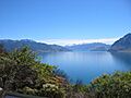
Lake Hāwea, looking north
-
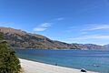
Lake Hāwea in summer
-
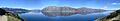
Lake Hāwea panorama
See also
 In Spanish: Lago Hawea para niños
