Millers Flat facts for kids
Quick facts for kids
Millers Flat
|
|
|---|---|
|
Rural settlement
|
|

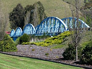
The heritage-listed Millers Flat Bridge, a four span steel truss bridge which crosses the Clutha River
|
|
| Country | New Zealand |
| Region | Otago region |
| Territorial authorities | Central Otago District |
| Ward | Teviot Valley Ward |
| Community | Teviot Valley Community |
| Electorates |
|
| Area | |
| • Urban area | 0.99 km2 (0.38 sq mi) |
| Population
(June 2023)
|
|
| • Urban area | 90 |
| • Density | 91/km2 (235/sq mi) |
| Time zone | UTC+12 (NZST) |
| • Summer (DST) | UTC+13 (NZDT) |
| Postcode |
9572
|
| Area code | 03 |
| Local iwi | Ngāi Tahu |
Millers Flat is a small town in the Otago region of New Zealand. It is located on the Clutha River, which is in the South Island. The town is about 17 kilometres south of Roxburgh.
Growing fruit is the main business in the Millers Flat area. Most of the town sits on the north side of the Clutha River. The main road, State Highway 8, runs along the other side of the river.
A railway line, called the Roxburgh Branch, used to go through the town. It opened in Millers Flat in 1925. The town was the end of the line for about two and a half years. Then, the railway was extended to Roxburgh. The line closed in 1968. You can still see the old station platform and some of the railway path today.
Millers Flat was first called Ovens Hill. Its current name comes from an early European settler, Walter Miller. He started farming in the area around 1849.
The Millers Flat Bridge was designed by Robert Hay. Building the bridge began in 1897 and it opened in 1899.
Contents
About Millers Flat
Millers Flat is a small rural settlement. It covers an area of 0.99 square kilometres. In 2018, about 87 people lived there. This means there were about 88 people for every square kilometre. Millers Flat is part of a larger area called Teviot Valley.
Population Changes
The population of Millers Flat has changed over the years.
- In 2006, there were 99 people.
- In 2013, the population was 90.
- In 2018, it was 87 people.
This shows a small decrease in the number of people living in the town.
Who Lives in Millers Flat?
In 2018, there were 87 people living in Millers Flat. There were 39 males and 48 females. The average age was 61.2 years. This is older than the national average age of 37.4 years.
- About 7% of the people were under 15 years old.
- About 10% were between 15 and 29 years old.
- About 41% were between 30 and 64 years old.
- About 41% were 65 years or older.
Most people (96.6%) were European/Pākehā. Some people (6.9%) identified as Māori. People could choose more than one ethnicity.
When asked about religion, about 48% said they had no religion. About 41% were Christian.
The Story of Somebody's Darling
About 8 kilometres down the Clutha River from Millers Flat, you can find the remains of the Horseshoe Bend Gold Diggings. This place is famous for the story of "Somebody's Darling" and the Lonely Graves.
In early 1865, the body of a young man was found at Rag Beach. This was upstream from where the Lonely Graves are now. On February 22, 1865, an investigation decided the body was Charles Alms. He had fallen into the river while swimming cattle.
The body was buried in an unmarked grave. Later that year, a miner named William Rigney arrived. He and John Ord built a fence around the grave. Rigney then made a simple headstone from wood. He used a nail to carve the words: "Somebody's Darling lies buried here."
In 1903, a marble headstone was put up. William Rigney died in 1912. He was buried next to "Somebody's Darling."
Education in Millers Flat
Millers Flat School is a public primary school. It teaches students from Year 1 to Year 8. It is a co-educational school, meaning both boys and girls attend.
 | May Edward Chinn |
 | Rebecca Cole |
 | Alexa Canady |
 | Dorothy Lavinia Brown |


