Haast, New Zealand facts for kids
Quick facts for kids
Haast
|
|
|---|---|
 |
|
| Country | New Zealand |
| Region | West Coast |
| District | Westland District |
| Ward | Southern |
| Electorates |
|
| Area | |
| • Total | 0.57 km2 (0.22 sq mi) |
| Population
(June 2023)
|
|
| • Total | 90 |
| • Density | 158/km2 (409/sq mi) |
| Time zone | UTC+12 (NZST) |
| • Summer (DST) | UTC+13 (NZDT) |
| Postcode |
7886
|
| Area code(s) | 03 |
| Local iwi | Ngāi Tahu |
Haast is a small town on the West Coast of New Zealand's South Island. It is located in the Westland District. The town sits next to the Haast River, about 3 kilometers (1.9 miles) south of Haast Junction. It is found along State Highway 6. The Haast area is part of Te Wahipounamu, which means "The South West New Zealand World Heritage Area." This special place was named a UNESCO World Heritage Site in 1990.
Contents
What's in a Name?
The town of Haast, the nearby Haast River, a gorge on the river, and the Haast Pass are all named after Julius von Haast. He was a geologist born in Prussia who explored this area in 1863. Even though a gold prospector named Charles Cameron was thought to be the first European to find the pass, Haast was honored by having the town named after him.
Haast's History
The Haast area has a rich history, especially for the Māori people.
Early Māori Life
The main Māori settlement in this area was a pā (a fortified village) called Ōkahu. It was located at the mouth of the Arawhata River. The Haast region was very important to Māori because it was a key place to find pounamu (greenstone). They used a main route from inland called Tioripatea to travel through the area.
Attacks from Other Tribes
The Ngāi Tahu people lived on this land. However, their control ended due to attacks from tribes from the North Island. In 1836, a chief named Te Pūoho from the Ngāti Tama tribe led a group of 100 warriors. They had muskets (old guns) and traveled down the West Coast and over the Haast Pass. They surprised a Ngāi Tahu camp between Lake Wānaka and Lake Hāwea. Their journey ended in Southland, where Te Pūoho was killed, and his group was defeated by the southern Ngāi Tahu leader Tūhawaiki.
European Exploration and Settlement
Europeans started settling in the Haast area in the 1860s. At first, it was hard to get to Haast because it was so remote. People mostly arrived by sea, or by using rough tracks from the north and east.
Early European explorers wanted to find the Māori routes that crossed the South Island. They learned about the pass when a Māori person named Huruhuru drew a map for explorer Edward Shortland in 1844. The first European to climb up from the Wānaka side was John Holland Baker in March 1861. He was a surveyor looking for new land for sheep. He looked down from the pass towards the West Coast.
A gold prospector named Charles Cameron said he was the first to cross to the coast in 1863. However, many people believed he only reached the upper parts of the Haast River / Awarua.
The honor of the first official crossing went to Julius von Haast. He was Canterbury's provincial geologist. He led a group of five men in January 1863. He named the Haast River after himself. His group traveled up the Makarora River. On January 23, they reached the open, swampy top of the pass. Haast made a watercolour painting of the area. The group then crossed the pass and traveled downstream to the coast, arriving on February 20.
Modern Haast
The town of Haast today started as a camp for road builders. This was when the New Zealand Ministry of Works was building the road. It grew into a permanent town when the Haast Pass road opened in 1962. This made the region much easier to reach. The road through the pass to Wānaka was improved in 1966.
In 1990, the Haast area became part of a UNESCO World Heritage Site. This means it is recognized internationally for its amazing natural beauty. It is called Te Wahipounamu – The South West New Zealand World Heritage Area.
Haast's Geography
Location and Surroundings
The town of Haast is located on the Haast River. It is about 3 kilometers (1.9 miles) south of Haast Junction, on State Highway 6. The Haast River, also known as Awarua in Māori, is 100 kilometers (62 miles) long. It flows into the Tasman Sea near the town. The river drains the western side of the Haast Pass. It also flows through a narrow valley called the Gates of Haast.
The New Zealand Department of Conservation has a visitor center in Haast Junction. It is on the southwest bank of the Haast River, just south of the Haast Bridge. This center offers lots of information about the area.
Lake Moeraki is about 30 kilometers (19 miles) to the northeast. The Haast Pass is about 63 kilometers (39 miles) to the southeast by road. The small settlement of Okuru is on the coast, about 12 kilometers (7.5 miles) southwest of Haast.
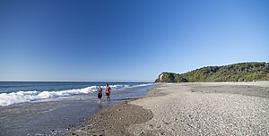
Haast Beach is a small settlement right on the coast of the Tasman Sea. It is about 4 kilometers (2.5 miles) west-southwest of Haast Junction, on the road to Jackson Bay.
Climate
Haast is known for being the wettest town in New Zealand. It gets a lot of rain!
| Climate data for Haast (1991–2020 normals, extremes 1949–present) | |||||||||||||
|---|---|---|---|---|---|---|---|---|---|---|---|---|---|
| Month | Jan | Feb | Mar | Apr | May | Jun | Jul | Aug | Sep | Oct | Nov | Dec | Year |
| Record high °C (°F) | 29.4 (84.9) |
28.3 (82.9) |
27.9 (82.2) |
24.9 (76.8) |
21.5 (70.7) |
17.7 (63.9) |
18.9 (66.0) |
19.9 (67.8) |
23.7 (74.7) |
23.3 (73.9) |
28.0 (82.4) |
27.3 (81.1) |
29.4 (84.9) |
| Mean daily maximum °C (°F) | 18.4 (65.1) |
18.8 (65.8) |
18.0 (64.4) |
16.0 (60.8) |
14.0 (57.2) |
12.1 (53.8) |
11.7 (53.1) |
12.3 (54.1) |
13.2 (55.8) |
14.2 (57.6) |
15.4 (59.7) |
17.1 (62.8) |
15.1 (59.2) |
| Daily mean °C (°F) | 14.7 (58.5) |
15.0 (59.0) |
14.0 (57.2) |
12.3 (54.1) |
10.5 (50.9) |
8.4 (47.1) |
7.8 (46.0) |
8.4 (47.1) |
9.3 (48.7) |
10.3 (50.5) |
11.6 (52.9) |
13.4 (56.1) |
11.3 (52.3) |
| Mean daily minimum °C (°F) | 11.0 (51.8) |
11.3 (52.3) |
10.0 (50.0) |
8.5 (47.3) |
6.9 (44.4) |
4.7 (40.5) |
4.0 (39.2) |
4.5 (40.1) |
5.4 (41.7) |
6.5 (43.7) |
7.9 (46.2) |
9.7 (49.5) |
7.5 (45.6) |
| Record low °C (°F) | 3.0 (37.4) |
2.8 (37.0) |
0.7 (33.3) |
−1.4 (29.5) |
−2.7 (27.1) |
−5.1 (22.8) |
−3.7 (25.3) |
−4.0 (24.8) |
−2.0 (28.4) |
−3.4 (25.9) |
−0.4 (31.3) |
1.0 (33.8) |
−5.1 (22.8) |
| Average rainfall mm (inches) | 255.7 (10.07) |
202.7 (7.98) |
246.2 (9.69) |
212.2 (8.35) |
267.8 (10.54) |
268.3 (10.56) |
251.5 (9.90) |
245.7 (9.67) |
299.5 (11.79) |
294.0 (11.57) |
240.9 (9.48) |
339.6 (13.37) |
3,124.1 (122.97) |
| Source: NIWA | |||||||||||||
People of Haast
Haast is a small rural settlement. In 2018, about 84 people lived there. The population has grown quite a bit since 2013.
| Historical population of the settlement | ||
|---|---|---|
| Year | Pop. | ±% p.a. |
| 2006 | 63 | — |
| 2013 | 54 | −2.18% |
| 2018 | 84 | +9.24% |
Most people in Haast are of European (Pākehā) background (89.3%). About 14.3% identify as Māori. Many people in Haast (53.6%) reported having no religion. About 32.1% were Christian.
Nature and Wildlife
Haast Tokoeka Kiwi
The Haast tokoeka is a very rare type of kiwi. More than half of all known Haast tokoeka live in the Haast ranges. This area is carefully managed to help protect these special birds.
What People Do in Haast
The main ways people earn a living in the Haast region are through farming, fishing, and tourism. Many visitors come to see the beautiful natural environment.
Haast's Infrastructure
Electricity
The Haast area is not connected to New Zealand's main electricity system. Instead, New Zealand Energy provides power to the town. Electricity is made by an 800-kilowatt hydroelectric power plant on the Turnbull River. This plant was built in 1972. A 375-kilowatt diesel generator is also available as a backup. In 2023, the company asked for permission to build a second hydro power station on the Turnbull River.
Communication
Haast got mobile phone service in May 2018. You can get 3G mobile coverage within about 3 kilometers (1.9 miles) of the town. Fast fibre broadband internet became available in Haast in 2022.
Education in Haast
The Haast School is a school for students in years 1 to 8 (ages 5-13). It is a coeducational school, meaning both boys and girls attend. The school opened in the 1890s and is the most isolated school on the mainland of New Zealand.
There are no high schools in the Haast area. The closest one is Mount Aspiring College, which is 140 kilometers (85 miles) away in Wānaka. This is too far for students to travel daily. Most secondary students from Haast live away from home to attend schools in places like Alexandra, Oamaru, or Dunedin.
See also
 In Spanish: Haast (Nueva Zelanda) para niños
 | William L. Dawson |
 | W. E. B. Du Bois |
 | Harry Belafonte |


