Arawhata River facts for kids
Quick facts for kids Arawhata River |
|
|---|---|

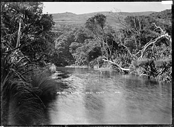
Anawhata River. Between 1900 and 1930.
|
|
| Native name | Arawhata |
| Other name(s) | Arawata River |
| Physical characteristics | |
| River mouth | Jackson Bay |
| Length | 60 kilometres (37 mi) |
| Basin features | |
| Tributaries |
|
The Arawhata River is a cool river found in the West Coast area of New Zealand's South Island. It's also sometimes called the Arawata River. This spelling comes from the Ngāi Tahu Māori dialect.
Contents
Where the River Starts and Ends
The Arawhata River begins high up in the mountains. Its source is in the beautiful Mount Aspiring National Park. This park is known for its stunning natural beauty.
The river flows down the western side of the Southern Alps. It travels north for about 60 kilometers (37 miles). Finally, it empties into Jackson Bay.
Near where the Arawhata River meets the sea, a small lake called Lake Ellery also drains into it. This happens through a short connecting river, the Jackson River.
Exploring the Arawhata River
You can travel up the Arawhata River by jetboat. This is a fun way to see the area. However, getting to the very top parts of the valley can be tricky. A place called Ten Hour Gorge makes it hard to reach the glaciers, forests, and flat areas further up.
The river water often looks a cloudy green or grayish color. This is because of tiny bits of rock and dirt. These come from the glaciers melting and flowing into the river.
Land Around the River
Local farmers use some of the lower valley land for grazing cattle. They have special permission to do this. Most of the land in this area is owned by the public. The Department of Conservation looks after it. They make sure the natural environment is protected.
River Levels
The western side of the Southern Alps gets a lot of rain. Because of this, the Arawhata River's water level can rise very quickly. It's important to be aware of this if you are near the river.
 | James B. Knighten |
 | Azellia White |
 | Willa Brown |

