
Jackson Bay / Okahu facts for kids
Quick facts for kids Jackson Bay / Okahu |
|
|---|---|

Jackson Bay / Okahu
|
|

Jackson Bay / Okahu
Location in New Zealand
|
|
| Location | Westland District, West Coast Region |
| Coordinates | 43°58′S 168°37′E / 43.967°S 168.617°E |
| Native name | Okahu Error {{native name checker}}: parameter value is malformed (help) |
| Part of | Tasman Sea |
| River sources | Arawhata River, Okuru River, Turnbull River, Waiatoto River |
| Basin countries | New Zealand |
| Islands | Open Bay Islands |
Jackson Bay / Okahu is a beautiful, gently curving bay in New Zealand. It stretches for about 24 kilometers (15 miles) along the southern West Coast of the South Island.
The bay faces the Tasman Sea to the north. Behind it rise the towering Southern Alps. Inside the bay, you'll find small communities like Hannahs Clearing, Waiatoto, and Neils Beach. At the western end is the fishing village of Jackson Bay. This bay is also the southernmost point you can reach by road on the West Coast.
Contents
Exploring Jackson Bay's Geography
The western edge of Jackson Bay is marked by a piece of land called Jackson Head. To the northeast, the bay ends near where the Turnbull and Okuru Rivers flow into the sea.
Just five kilometers (3 miles) off the coast are the small Open Bay Islands, named Taumaka and Popotai.
How the Land Changes
Jackson Bay marks a big change in the landscape of the West Coast. North of the bay, there are flat, fertile plains between the mountains and the sea. These areas are used for dairy and deer farming.
South of the bay, the flat land disappears. The coast becomes much steeper and more mountainous. Not far from the bay, you start to see deep valleys carved by glaciers. These valleys become the famous fjords of Fiordland further south.
Getting to Jackson Bay
To reach Jackson Bay, you take a small road from Haast. Haast is about 32 kilometers (20 miles) northeast of the bay, located on State Highway 6.
The road crosses the Okuru and Waiatoto Rivers. After crossing the Arawhata River, it turns northeast and ends at the village of Jackson Bay.
A Special Harbour
Jackson Bay is the only sheltered harbour between Greymouth (270 km or 168 miles north) and Milford Sound (100 km or 62 miles south). However, "sheltered" is a relative term, as it's still open to strong storms from the north.
The waters off the coast are very rich in sea life. This is because cool ocean currents from the west meet warmer currents from the Westland area here.
The Story Behind the Name
When Captain Cook first explored this area, he named the bay Open Bay. The reason for its current name, Jackson Bay, isn't completely clear.
Some people think it was named after Port Jackson in Australia. Others believe it was named after James Hayter Jackson, a local whaler. Another idea is that it's named after William Jackson, a sealer who might have been left stranded in the area in 1810. In the early days, it was called Jackson's Bay, but the apostrophe was later dropped.
In 1998, the bay's name was officially changed to Jackson Bay / Okahu. This happened after the Ngai Tahu Claims Settlement Act 1998, which recognized the historical importance of Māori names.
A Glimpse into History
For hundreds of years, the Jackson Bay area was home to a Māori settlement. Māori people lived near the mouth of the Arawhata River. They caught fish and seals and collected valuable pounamu (greenstone) from the nearby Red Hills.
When a whaler named John Boultbee visited in 1826, about 300 Māori lived there. However, the population had decreased by the time Europeans started settling. The Māori settlement was finally abandoned in 1866.
Whaling and Early European Attempts
In 1842, a whaler named Thomas Chaseland set up a station in Jackson Bay. He knew the spot from his time as a sealer. His goal was to catch migrating whales like southern right and humpbacks.
In 1874, the government tried to create a new settlement in Jackson Bay. They had a plan for a seaport called Arawata, with streets and a waterfront. The idea was for it to become a busy port supporting fishing, logging, mining, and farming.
Immigrants from many countries arrived in 1875. But they faced many problems: the land was often flooded and not good for farming. There was also a lot of rain, many sandflies, and the area felt very isolated. Plus, there was no proper wharf or road. Within three years, most of the settlers had left.
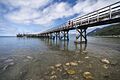
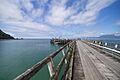
Building the Wharf and Roads
A wharf was finally built in Jackson Bay in 1938. This allowed large road-building machines to be brought in for the new Haast highway. A road was then built from Jackson Bay to Haast and over the Haast Pass.
The wharf helped start a timber and fishing industry. However, logging didn't last long because it was cheaper to cut trees closer to the main markets.
Jackson Bay Today
Today, Jackson Bay is New Zealand's closest harbour to Australia. It's still an important place for fishing. Small boats catch mostly tuna and spiny lobster (also called crayfish or koura in New Zealand). Not many fishers live in the bay permanently.
The settlement has about 30 houses, but only a few people live there all year round. In summer, many people from Central Otago or Queenstown come with their boats for weekend fishing trips. This has led local iwi (Māori tribes) like Te Rūnanga o Makaawhio to talk about setting up mataitai (marine reserves) to protect the sea life.
Local Landmarks
On the shore of Jackson Bay, you can find a grave and a marker for Claude Ollivier. He was from the schooner Ada and died in Jackson Bay on August 27, 1862.
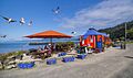
Also on the foreshore is The Craypot, a famous fish-and-chip stand. It's one of the main attractions for visitors. The Craypot started as a pie cart in Timaru. It was later moved to Cromwell to help feed workers building the Clyde Dam in the 1980s. Around 2001, a local from Haast bought it. They towed it over the Haast Pass with a tractor and set it up on the Jackson Bay waterfront.
After a big storm called Cyclone Fehi in 2018, the local council added a rock wall to the foreshore. The wharf was also improved in 2021, using money from a special fund for the West Coast.
Images for kids
-
A view of the bay from the shore.
-
Boats docked at the Jackson Bay wharf.
-
The rugged coastline near Jackson Bay.
-

A closer look at the fishing boats.


