
Waiatoto River facts for kids
Quick facts for kids Waiatoto River |
|
|---|---|
 |
|
| Native name | Waiatoto |
| Country | New Zealand |
| Region | West Coast |
| District | Westland |
| Physical characteristics | |
| Main source | Mount Aspiring, Volta Glacier |
| River mouth | Jackson Bay |
| Length | 52 kilometres (32 mi) |
| Basin features | |
| Tributaries |
|
The Waiatoto River is a beautiful river located on the West Coast of New Zealand's South Island. It starts high up in the mountains, fed by melting ice from glaciers around Mount Aspiring. This river flows for about 52 kilometers (32 miles) before reaching the Tasman Sea.
The name "Waiatoto" comes from the Māori language. It means "water of blood." Much of this river flows through the amazing Mount Aspiring National Park, a protected area known for its stunning natural beauty.
Exploring the Waiatoto River
The Waiatoto River begins its journey from several small rivers. These rivers are fed by the Volta Glacier and other glaciers near Mount Aspiring. This tall mountain is a famous landmark in New Zealand.
River's Path to the Sea
From its icy beginnings, the Waiatoto River flows north through a long valley. On its western side, you can see the Haast Range mountains. After a while, the river turns towards the northwest. It then travels about 20 kilometers (12 miles) southwest of the town of Haast before finally emptying into the Tasman Sea.
Nature and Wildlife
A large part of the Waiatoto River runs inside Mount Aspiring National Park. This park is a special place where nature is protected. It is home to many native plants and animals. The river and its surrounding areas provide a habitat for various species.
Images for kids
-
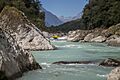
The Waiatoto River flowing through the valley.
-
A view of the Waiatoto River with mountains in the background.
-
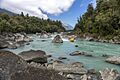
The clear waters of the Waiatoto River.


