Mount Aspiring / Tititea facts for kids
Quick facts for kids Mount Aspiring / Tititea |
|
|---|---|
 |
|
| Highest point | |
| Elevation | 3,033 m (9,951 ft) |
| Prominence | 2,475 m (8,120 ft) |
| Listing | Ultra New Zealand #9 |
| Naming | |
| Native name | Error {{native name}}: an IETF language tag as parameter {{{1}}} is required (help) |
| Geography | |
| Parent range | Southern Alps |
| Climbing | |
| First ascent | 1909 |
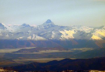
Mount Aspiring, also known as Tititea, is a stunning mountain in New Zealand. It is the 23rd tallest mountain in the country. It is also the highest peak outside the famous Aoraki / Mount Cook area.
Contents
About Mount Aspiring / Tititea
Mount Aspiring / Tititea is located in Otago's beautiful Mount Aspiring National Park. This impressive mountain stands at 3,033 meters (9,951 feet) tall. The Māori people gave it the name Tititea, which means Glistening Peak. This name perfectly describes how the snow-capped peak shines.
Naming and First Climb
The mountain was officially named Mount Aspiring in December 1857. This was done by John Turnbull Thomson, who was the Chief Surveyor for the Otago Province. Many people also call it 'the Matterhorn of the South'. This is because its peak looks like a pyramid when you see it from the Matukituki River.
The first time someone successfully climbed to the top was on November 23, 1909. This historic climb was made by Major Bernard Head and his guides, Jack Clarke and Alec Graham. They reached the summit by climbing the west face from the Bonar Glacier. This specific route was so challenging that it was not climbed again until 1965!
Location and Glaciers
Mount Aspiring / Tititea is found slightly west of the main mountain range. It is about 30 kilometers (19 miles) west of Lake Wānaka. The mountain sits where three large glacier systems meet.
- The Bonar Glacier flows into the Waipara River.
- The Volta Glacier and Therma Glacier both flow into the Waiatoto River.
The Waipara River is a branch of the Arawhata River. Both the Arawhata and Waiatoto Rivers flow out to the west coast. They reach the sea between Haast and Jackson Bay.
Climbing Adventures
Mount Aspiring is a very popular spot for climbers and hikers. The most common way to reach the mountain starts in the West Matukituki Valley. You can get there by driving about 50 kilometers (31 miles) from Wanaka to Raspberry Flat. From this point, a network of huts helps climbers prepare for their journey.
Starting the Climb
The first hut is called Mount Aspiring Hut. It is about 8 kilometers (5 miles) from the end of the road. This usually takes about two hours to walk. The next part of the journey to the higher huts is much longer and harder. It can take 8 to 12 hours of hiking. Much of this path is not a clear trail.
Reaching the Summit
The trail only guides you for the first half of the approach. It winds through the flat valley floor. After the trail ends, climbers have two main options to reach the Bonar Glacier:
- You can climb up the French Ridge.
- You can ascend Bevan Col.
Both of these routes need good skills in finding your way. You also need to know about rock climbing and how to travel safely on glaciers. Because the journey is so tough, many climbers choose to fly in by helicopter. This helps them save energy for the actual climb.
Safety on the Mountain
Even though the mountain and park are very popular, climbing can be dangerous. There have been a number of accidents over the years. Climbers need to be well-prepared and careful.
See also
 In Spanish: Monte Aspiring para niños
 | Stephanie Wilson |
 | Charles Bolden |
 | Ronald McNair |
 | Frederick D. Gregory |


