Oamaru facts for kids
Quick facts for kids
Oamaru
Te Oha-a-Maru (Māori)
|
|
|---|---|
|
Town
|
|

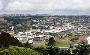
Oamaru from South Hill (2011)
|
|
| Country | New Zealand |
| Region | Otago |
| Territorial authority | Waitaki District |
| Ward | Oamaru Ward |
| Electorates |
|
| Area | |
| • Total | 20.21 km2 (7.80 sq mi) |
| Population
(June 2023)
|
|
| • Total | 14,000 |
| • Density | 693/km2 (1,790/sq mi) |
| Demonym(s) | Oamaruvian |
| Time zone | UTC+12 (NZST) |
| • Summer (DST) | UTC+13 (NZDT) |
| Post code |
9400
|
| Area code | 03 |
| Local iwi | Ngāi Tahu |
Oamaru (pronounced OH-mah-roo) is the biggest town in North Otago, located on the South Island of New Zealand. It's the main town in the Waitaki District. Oamaru is about 80 kilometers south of Timaru and 120 kilometers north of Dunedin, right on the Pacific Ocean coast. You can reach both cities using State Highway 1 and the Main South Line railway.
With a population of 14,000, Oamaru is the 28th largest urban area in New Zealand. It's the third largest in Otago, after Dunedin and Queenstown. Oamaru is the center of the Waitaki District, which also includes smaller towns like Kurow, Weston, Palmerston, and Hampden. Together, these areas have a total population of 23,200 people.
Friendly Bay is a popular spot for fun and relaxation, right next to Oamaru Harbour. North of Oamaru, you'll find a large meat processing plant at Pukeuri. This area is also an important road junction for State Highway 83, which leads into the Waitaki Valley. This road connects to places like Kurow, Omarama, Otematata, and eventually to Queenstown and Wānaka through the Lindis Pass. Oamaru is often called the eastern gateway to the Mackenzie Basin because of this route.
The town of Oamaru is built between rolling limestone hills and a flat area near the sea. The local limestone, called "Oamaru stone" or "Whitestone," is used to construct many of the town's buildings. Oamaru is protected by Cape Wanbrow. The town was planned in 1858 by a surveyor named John Turnbull Thomson. He named the early streets after famous British rivers. The name Oamaru comes from the Māori language and means 'the place of Maru'. We don't know for sure who Maru was.
Contents
History of Oamaru
Early Māori Life
There are important old sites around Oamaru that show how Māori people lived long ago. Places like the Waitaki River mouth and Awamoa date back to the Archaic period (when people hunted moa) around AD 1100. At the Waitaki River mouth, archaeologists found evidence of at least 1,200 ovens! Awamoa was also the site of New Zealand's first archaeological dig in 1847. Smaller sites exist at Cape Wanbrow and Beach Road in Oamaru. The unique rock art found in the Waitaki Valley also comes from this time. Later Māori sites, from after AD 1500, are found at Tamahaerewhenua, Tekorotuaheka, Te Punamaru, Papakaio, and Kakanui.
Māori stories tell of an ancient canoe called Ārai Te Uru. It sailed from southern New Zealand to the ancestral Polynesian homeland, Hawaiki, to bring back kūmara. On its way back, it got stuck near the Waitaki River mouth. It lost food baskets at Moeraki beach and eventually crashed at Matakaea (Shag Point), turning into Danger Reef. After the crash, a crew member named Pahihiwitahi looked for water and found the Waitaki River. But he didn't make it back to the wreck before sunrise and was turned into a hill in the Shag Valley. Some experts believe this story explains why kūmara doesn't grow well south of Banks Peninsula.
European Arrivals
On February 20, 1770, James Cook and his ship, the Endeavour, sailed very close to the Waitaki River mouth. Cook wrote in his journal that the land was "very low and flat" and looked "barren." He didn't see any signs of people living there, but Māori did live in the area.
In 1814, sealers visited the coast. An old document from 2003 tells a story about a group of sealers who landed north of Moeraki. They were attacked by local Māori, and some of the sealers were killed. Two escaped but were later found and also killed. This event involved a party from the ship Matilda.
After a major battle at Kaiapoi (near modern Christchurch) in 1831, Māori refugees moved south. They were allowed to settle at Kakanui, and the land between Pukeuri and Waianakarua, including where Oamaru is today, became their home.
Growth of the Town
Whalers sometimes visited this coast in the 1830s. For example, the ship Jason was reported near "Otago Bluff" in 1839.
Edward Shortland traveled through the area in 1844. He noted the landscape and made a map that included Oamaru. Other Europeans also passed through in the 1840s. James Saunders became the first European to live in the district before 1850, trading with Māori at the Waitaki River mouth.
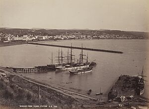
More European settlers arrived in the 1850s. Hugh Robison built a hut in 1853 while setting up his sheep station. J.T. Thomson planned Oamaru as a town in 1859. The town grew quickly as a service center for the farms and sheep stations in the area. It also became a major port, especially after a breakwater was built starting in 1871 to make the harbor safer.
Oamaru became very successful with the growth of farming and the frozen meat industry. The first frozen meat shipment from New Zealand actually started just south of Oamaru at Totara. Many important buildings were constructed, like the Athenaeum, the Chief Post Office, and Waitaki Boys' and Waitaki Girls' High Schools. These buildings were often made from the local Oamaru stone, which is easy to carve. By the 1880s, Oamaru was known for its impressive buildings.
A big project that caused financial trouble for the town was the Oamaru Borough Water Race. This aqueduct was finished in 1880. It brought clean water from the Waitaki River almost 50 kilometers away to Oamaru. This was a huge engineering achievement, but it was very expensive. The aqueduct was used until 1983, and much of it can still be seen today.
From 1906 to 1960, Oamaru was a "dry" town, meaning alcohol sales were not allowed. It was the last district in the South Island to start selling alcohol again.
Development slowed down in the 1970s when the port closed. In the 1980s, New Zealand's economy changed a lot, and North Otago faced tough times, including droughts. To bounce back, Oamaru started focusing on its unique old buildings. The Forrester Gallery, an art museum, opened in 1983. The Oamaru Whitestone Civic Trust was formed in 1987 to restore the historic area near the port. This area, with its old commercial buildings, is now one of the most special places in New Zealand. By 2014, the Trust owned 17 historic buildings.
Oamaru's Climate
Oamaru has an oceanic climate, which means it has mild temperatures all year round.
| Climate data for Oamaru (1991–2020 normals, extremes 1966–present) | |||||||||||||
|---|---|---|---|---|---|---|---|---|---|---|---|---|---|
| Month | Jan | Feb | Mar | Apr | May | Jun | Jul | Aug | Sep | Oct | Nov | Dec | Year |
| Record high °C (°F) | 33.8 (92.8) |
37.4 (99.3) |
32.0 (89.6) |
27.5 (81.5) |
25.8 (78.4) |
21.2 (70.2) |
20.2 (68.4) |
23.2 (73.8) |
26.1 (79.0) |
29.6 (85.3) |
31.3 (88.3) |
33.6 (92.5) |
37.4 (99.3) |
| Mean maximum °C (°F) | 29.4 (84.9) |
28.5 (83.3) |
27.4 (81.3) |
23.5 (74.3) |
21.0 (69.8) |
17.9 (64.2) |
17.8 (64.0) |
19.4 (66.9) |
22.3 (72.1) |
24.7 (76.5) |
26.9 (80.4) |
27.4 (81.3) |
31.2 (88.2) |
| Mean daily maximum °C (°F) | 19.7 (67.5) |
19.3 (66.7) |
18.4 (65.1) |
16.1 (61.0) |
13.9 (57.0) |
11.6 (52.9) |
11.0 (51.8) |
11.6 (52.9) |
13.7 (56.7) |
15.4 (59.7) |
16.8 (62.2) |
18.2 (64.8) |
15.5 (59.9) |
| Daily mean °C (°F) | 15.2 (59.4) |
15.0 (59.0) |
13.8 (56.8) |
11.5 (52.7) |
9.3 (48.7) |
7.2 (45.0) |
6.5 (43.7) |
7.4 (45.3) |
9.2 (48.6) |
10.7 (51.3) |
12.1 (53.8) |
13.9 (57.0) |
11.0 (51.8) |
| Mean daily minimum °C (°F) | 10.7 (51.3) |
10.6 (51.1) |
9.1 (48.4) |
6.9 (44.4) |
4.8 (40.6) |
2.7 (36.9) |
2.0 (35.6) |
3.1 (37.6) |
4.7 (40.5) |
6.0 (42.8) |
7.5 (45.5) |
9.6 (49.3) |
6.5 (43.7) |
| Mean minimum °C (°F) | 5.3 (41.5) |
5.6 (42.1) |
3.8 (38.8) |
1.9 (35.4) |
0.1 (32.2) |
−1.4 (29.5) |
−2.0 (28.4) |
−1.1 (30.0) |
−0.4 (31.3) |
0.8 (33.4) |
2.2 (36.0) |
4.5 (40.1) |
−2.3 (27.9) |
| Record low °C (°F) | 0.6 (33.1) |
1.1 (34.0) |
0.6 (33.1) |
−1.1 (30.0) |
−4.2 (24.4) |
−4.4 (24.1) |
−5.4 (22.3) |
−5.6 (21.9) |
−1.6 (29.1) |
−2.0 (28.4) |
0.2 (32.4) |
0.7 (33.3) |
−5.6 (21.9) |
| Average rainfall mm (inches) | 50.2 (1.98) |
51.5 (2.03) |
43.2 (1.70) |
68.5 (2.70) |
73.4 (2.89) |
43.6 (1.72) |
59.2 (2.33) |
46.0 (1.81) |
30.3 (1.19) |
55.5 (2.19) |
58.5 (2.30) |
58.7 (2.31) |
638.6 (25.15) |
| Source: NIWA | |||||||||||||
| Climate data for Oamaru Airport (1991–2020 normals, extremes 1967–1985, 1999–present) | |||||||||||||
|---|---|---|---|---|---|---|---|---|---|---|---|---|---|
| Month | Jan | Feb | Mar | Apr | May | Jun | Jul | Aug | Sep | Oct | Nov | Dec | Year |
| Record high °C (°F) | 33.4 (92.1) |
37.7 (99.9) |
30.5 (86.9) |
26.9 (80.4) |
26.1 (79.0) |
22.7 (72.9) |
20.0 (68.0) |
22.6 (72.7) |
26.4 (79.5) |
30.4 (86.7) |
30.9 (87.6) |
31.9 (89.4) |
37.7 (99.9) |
| Mean maximum °C (°F) | 29.0 (84.2) |
27.8 (82.0) |
26.2 (79.2) |
23.3 (73.9) |
20.5 (68.9) |
18.0 (64.4) |
17.2 (63.0) |
18.7 (65.7) |
21.8 (71.2) |
24.0 (75.2) |
26.1 (79.0) |
27.4 (81.3) |
30.9 (87.6) |
| Mean daily maximum °C (°F) | 19.5 (67.1) |
19.2 (66.6) |
18.1 (64.6) |
15.6 (60.1) |
13.3 (55.9) |
11.1 (52.0) |
10.5 (50.9) |
11.5 (52.7) |
13.7 (56.7) |
15.2 (59.4) |
16.6 (61.9) |
18.3 (64.9) |
15.2 (59.4) |
| Daily mean °C (°F) | 15.1 (59.2) |
14.9 (58.8) |
13.5 (56.3) |
10.9 (51.6) |
8.5 (47.3) |
6.2 (43.2) |
5.5 (41.9) |
6.6 (43.9) |
8.6 (47.5) |
10.2 (50.4) |
11.9 (53.4) |
14.0 (57.2) |
10.5 (50.9) |
| Mean daily minimum °C (°F) | 10.7 (51.3) |
10.5 (50.9) |
8.9 (48.0) |
6.2 (43.2) |
3.7 (38.7) |
1.3 (34.3) |
0.4 (32.7) |
1.7 (35.1) |
3.4 (38.1) |
5.3 (41.5) |
7.2 (45.0) |
9.6 (49.3) |
5.7 (42.3) |
| Mean minimum °C (°F) | 4.9 (40.8) |
5.0 (41.0) |
3.1 (37.6) |
0.9 (33.6) |
−1.4 (29.5) |
−3.1 (26.4) |
−4.0 (24.8) |
−3.0 (26.6) |
−2.0 (28.4) |
0.1 (32.2) |
1.6 (34.9) |
4.5 (40.1) |
−4.3 (24.3) |
| Record low °C (°F) | 1.8 (35.2) |
2.4 (36.3) |
0.8 (33.4) |
−1.6 (29.1) |
−4.0 (24.8) |
−5.7 (21.7) |
−6.3 (20.7) |
−4.8 (23.4) |
−5.0 (23.0) |
−2.4 (27.7) |
−0.8 (30.6) |
1.1 (34.0) |
−6.3 (20.7) |
| Average rainfall mm (inches) | 50.4 (1.98) |
47.6 (1.87) |
39.7 (1.56) |
44.0 (1.73) |
44.6 (1.76) |
42.8 (1.69) |
42.3 (1.67) |
45.8 (1.80) |
31.5 (1.24) |
39.5 (1.56) |
47.7 (1.88) |
53.3 (2.10) |
529.2 (20.84) |
| Source: NIWA | |||||||||||||
People of Oamaru
Oamaru is a medium-sized urban area. In 2018, it had a population of 13,107 people. This was an increase of 801 people since 2013.
| Historical population | ||
|---|---|---|
| Year | Pop. | ±% p.a. |
| 2006 | 12,030 | — |
| 2013 | 12,306 | +0.32% |
| 2018 | 13,107 | +1.27% |
In 2018, there were 5,463 households in Oamaru. There were more females (6,840) than males (6,267). About 17.8% of the population was under 15 years old. A large portion, 25.4%, were 65 or older.
Most people in Oamaru (86.9%) are of European descent. Other groups include Māori (8.1%), Pasifika (6.0%), and Asian (4.7%). About 15.7% of the people in Oamaru were born outside New Zealand.
When it comes to religion, 45.4% of people said they had no religion. 43.6% were Christian. Smaller numbers followed other religions like Hinduism, Islam, and Buddhism.
About 11.5% of people aged 15 or older had a university degree. 28.0% had no formal qualifications. Many people (43.3%) worked full-time, and 14.3% worked part-time.
| Name | Area (km2) | Population | Density (per km2) | Households | Median age | Median income |
|---|---|---|---|---|---|---|
| Glen Warren | 1.80 | 1,632 | 907 | 675 | 46.0 years | $24,500 |
| Holmes Hill | 2.62 | 1,332 | 508 | 603 | 54.1 years | $26,700 |
| Oamaru Central | 0.96 | 294 | 306 | 132 | 59.4 years | $21,500 |
| Oamaru Gardens | 1.42 | 1,179 | 830 | 522 | 47.3 years | $27,900 |
| Oamaru North Milner Park | 7.13 | 2,529 | 355 | 981 | 48.0 years | $24,400 |
| Oamaru North Orana Park | 2.76 | 2,907 | 1,053 | 1,158 | 42.3 years | $26,000 |
| South Hill | 1.45 | 2,184 | 1,506 | 981 | 46.1 years | $28,000 |
| Weston | 3.31 | 1,050 | 317 | 411 | 46.0 years | $34,900 |
| New Zealand | 37.4 years | $31,800 |
Fun and Activities
The beautiful Oamaru Opera House is a key place for live shows and performances in Oamaru. It first opened in 1907 and was restored in 2009. The restoration even won awards for its design and heritage conservation. It's a very important historic site for the town and New Zealand.
The Waitaki District Library has several branches, including one in Oamaru. The Oamaru Public Library started as the Oamaru Athenaeum and Mechanics Institute in 1878. A new library building opened in 1975.
The Oamaru Repertory Theatre on Itchen Street is where you can watch local live theater productions.
Sports in Oamaru
Oamaru has many sports facilities for activities like rugby, tennis, swimming, netball, cricket, golf, hockey, and bowls. Centennial Park is the main sports venue and home to North Otago Rugby Football Union and North Otago Cricket. The town also has the Oamaru Aquatic Centre for swimming.
Famous People from Oamaru
Many famous people have connections to Oamaru:
- The writer Janet Frame grew up here, and her early books often describe Oamaru life.
- Other writers like Owen Marshall, Greg McGee, and Fiona Farrell Poole also have ties to the town.
- Des Wilson, who started the UK charity Shelter for homeless people, was born and educated in Oamaru.
- Chris Watson, a former Prime Minister of Australia, came from Oamaru.
- New Zealand politicians Arnold Nordmeyer and William Steward were also from here.
- Cardinal Thomas Stafford Williams was born in Oamaru.
- Sir Malcolm Grant, a former leader of University College London and Chairman of NHS England, is from Oamaru.
- Famous All Blacks rugby union captain Richie McCaw was born and educated in Oamaru.
- Fred Allen, an All Black player and coach, was born in Oamaru.
- Gary Robertson, who won a gold medal in rowing at the 1972 Olympics, grew up in Oamaru and went to Waitaki Boys High School. He is the only Olympic gold medalist from Waitaki.
The world first learned about the death of explorer Robert Scott and his team from their trip to the South Pole through a message sent from Oamaru on February 10, 1913.
Frank Milner was the headteacher at Waitaki Boys' High School from 1906 to 1944. Many notable students attended the school during his time, including:
- Charles Brasch, a poet.
- Douglas Lilburn, a famous New Zealand composer.
- James Bertram, a writer and academic.
- Denis Blundell, who later became a Governor-General of New Zealand.
- Ian Milner, a scholar.
E.A. Gifford, a well-known artist, lived in Oamaru for many years. His painting Auckland from the Wharf is a famous image of 19th-century Auckland. Emily Gillies, another Oamaru artist, was related to the famous English artist and writer Edward Lear.
The artist Colin McCahon lived in Oamaru as a child, and the North Otago landscape influenced his work. Cartoonist John Kent, who created the Varoomshka comic strip, was also from Oamaru.
Today, Oamaru has a lively community of artists. Many art galleries are in the historic area. One local artist, Donna Demente, is known for her portraits and masks. Partly because of her work, Oamaru hosts an annual mask festival called the "Midwinter Masquerade" every July. Another yearly event is the Victorian Heritage fête in November.
Other notable former Oamaru residents include broadcaster Jim Mora and hockey player Scott Anderson. David Sewell played one test match for the New Zealand cricket team. Video game designer Dean Hall grew up in Oamaru and climbed Mount Everest in 2013.
Places to Visit
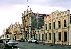
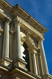
Oamaru has over 70 buildings listed as historic places. Many public buildings are made from the local Oamaru stone, which is quarried nearby. The Victorian precinct in Oamaru is one of New Zealand's most impressive areas because of its many grand 19th-century buildings made from this stone. Several important historic buildings in the Harbour Street and lower Thames Street area have been saved by the Oamaru Whitestone Civic Trust. The grand St Patrick's Basilica is another great example of Oamaru stone architecture.
Shops and galleries in this historic area have embraced the Victorian theme with their decorations. You'll find arts and crafts shops, a transportation museum, antique shops, and traditional businesses like book shops and clothing stores. Many of these buildings used to be warehouses and now house galleries like the Forrester Gallery, the Grainstore Gallery, The Libratory, and Steampunk HQ. Even the playgrounds in the harbor area have a Victorian or industrial steam theme, with a giant penny-farthing structure for swings and steampunk-style play features.
In August 2016, Oamaru set a Guinness Book of World Records for the largest gathering of steampunks. Steampunk is a style that imagines inventions Victorians might have created for the modern world.
The main shopping and business areas are along Thames Street, Severn Street, and State Highway 1. The historic commercial buildings are mostly found around lower Thames, Tees, and Tyne Streets.
A colony of little blue penguins lives in a disused quarry near the harbor, close to the historic area. The penguins moved in during the early 1990s after the quarry closed. In 1992, volunteers started helping to make the area a good home for the penguins and offered guided tours. Their efforts were successful, and the colony received an environmental award in 1995. Today, the Oamaru Blue Penguin Colony is Oamaru's biggest tourist attraction, with over 75,000 visitors each year. It's owned by the Waitaki District Council and carefully managed to protect the penguins.
A steam train, run by the Oamaru Steam and Rail Restoration Society, operates between a small railway station in the historic precinct and the harbor near the penguin colony. It runs on Sundays and during school holidays.
Further south, outside of town, a colony of yellow-eyed penguins at Bushy Beach also attracts visitors interested in nature. Sometimes, penguins even live under buildings near the beach, like the town's music club, The Penguin Club.
The historic Totara Estate is located 8 kilometers south of Oamaru. This site is important because it's where the New Zealand frozen meat industry began. In 1882, the ship Dunedin made its historic sailing from here, carrying the first frozen meat exports. By 1902, frozen meat made up 20% of all New Zealand exports.
Tourism Waitaki is the official group that promotes tourism for the entire Waitaki District.
Media in Oamaru
The Oamaru Mail is a weekly newspaper published every Friday. It has reporters in Oamaru who also write for the Otago Daily Times. This newspaper has served the Waitaki region since 1876. The Oamaru Telegram is another local newspaper, published every Tuesday.
Oamaru is also covered by Radio Dunedin. It has its own community television station, "45 South Television," and an independent classic rock radio station called Real Classic Rock. Oamaru FM 91.2 is another local radio station.
Getting Around Oamaru
Oamaru is located on State Highway 1 (SH1), which is the main road along the eastern coast of the South Island. You can find regular bus and minibus services to Christchurch, Dunedin, and the Mackenzie Country. These services leave from Eden Street.
Oamaru is the end point of the Alps to Ocean Cycle Trail, which starts at Aoraki / Mount Cook. This cycle trail was approved in 2010 and ends at Friendly Bay, right next to Oamaru's historic area.
Oamaru Airport is 20 kilometers north of the town at Pukeuri. While there were some scheduled flights in the past, they are not currently running.
The main south railway line, part of the South Island Main Trunk Railway, goes through Oamaru. A short side track connects Oamaru's historic precinct and a disused quarry at the harbor. A tourist steam train runs on this track on Sundays. The Oamaru railway station, built in 1900, is a listed historic building.
Education in Oamaru
Oamaru has three secondary schools for students in years 9 to 13:
- Waitaki Boys' High School is a boys' school with day and boarding options. It was founded in 1883 and has about 415 students.
- Waitaki Girls' High School is a state high school for girls. It was founded in 1887 and has about 401 students. It also has a boarding hostel.
- St Kevin's College, Oamaru is a co-educational Catholic high school with day and boarding options. It was founded in 1927 and has about 381 students.
St Joseph's School is the only Catholic primary school in North Otago. It teaches students up to year 8 and has about 103 students.
Oamaru Intermediate provides education for students in years 7 and 8. It has about 285 students.
Other state primary schools in Oamaru, for students up to year 6, include:
- Fenwick School, with about 276 students.
- Pembroke School, with about 220 students.
- Te Pākihi O Maru (formerly Oamaru North School), with about 115 students.
Schools in the surrounding areas include Weston School, Ardgowan School, Totara School, and Five Forks School.
Sister City
Oamaru has a sister city:
- Devizes, England
See also
 In Spanish: Oamaru para niños
 | Percy Lavon Julian |
 | Katherine Johnson |
 | George Washington Carver |
 | Annie Easley |


