
Palmerston, New Zealand facts for kids
Quick facts for kids
Palmerston
|
|
|---|---|
|
Town
|
|

Palmerston Town Hall
|
|
| Country | New Zealand |
| Region | Otago |
| Territorial authority | Waitaki District |
| Ward | Waihemo Ward |
| Community | Waihemo Community |
| Electorates |
|
| Area | |
| • Total | 8.75 km2 (3.38 sq mi) |
| Population
(June 2023)
|
|
| • Total | 1,030 |
| • Density | 117.7/km2 (304.9/sq mi) |
| Time zone | UTC+12 (NZST) |
| • Summer (DST) | UTC+13 (NZDT) |
| Local iwi | Ngāi Tahu |
Palmerston is a small town in the South Island of New Zealand. It is about 50 kilometers north of the city of Dunedin. Palmerston is the biggest town in the Waihemo area of the Waitaki District. About 890 people live there.
The town grew because it was a major road crossing. State Highway 1 connects Dunedin to the south with Oamaru and Christchurch to the north. State Highway 85, also called "The Pigroot," goes inland to the Maniototo area. The main railway line, called the Main South Line, also goes through the town. A special tourist train, the Seasider, travels from Dunedin to Palmerston and back a few times a week.
Palmerston is close to the Waihemo / Shag River, about five kilometers from the Pacific Ocean. Between the town and the sea is a hill called Puketapu. Its Māori name means sacred hill. People in the South Island often call it Holy Hill. On top of Puketapu is a monument to Sir John McKenzie, a politician from the 1800s. Every year, there is a race up to the monument and back. It is called Kelly's Canter. This race honors Albert Kelly, a police officer who ran up Puketapu every day during World War II.
Many people get Palmerston confused with a much larger city in the North Island called Palmerston North. People from Palmerston North often just call their city "Palmerston." However, the town in Otago was named first. It was surveyed in 1862, while the northern city got its name in 1871. Both towns are named after Lord Palmerston, who was a British Prime Minister in the 1800s.
The nearby Shag River is named after the cormorant. This is a seabird that sometimes goes a little inland. People often call it a 'shag'. The river's Māori name, 'Waihemo', means 'Dwindle River'. This is because the river often becomes a small stream in summer. Palmerston used to be the main town of Waihemo County. This was the area around it. But in 1989, it joined the Waitaki District.
Contents
History and Early Settlers
The area around Palmerston has a long and interesting history. Scientists who study old cultures believe that the first Polynesian people came to New Zealand around 1150 AD. They mostly lived on the east coast of the South Island.
There is a very old settlement site near Palmerston. It is at the mouth of the Shag River, right by the sea. This site belongs to the Archaic or moa hunter time of Māori culture. Europeans knew about it since the 1840s. Archaeologists have studied it for a long time. In 1987 and 1989, a team led by Professor Atholl Anderson dug up the site very carefully. They found that people lived there all year round for about 20 to 50 years in the 1300s AD.
The area is also part of a traditional Māori story. This story is about the wreck of the Arai Te Uru canoe. There are different versions of the story. They tell how Rākaihautū arrived from the homeland of Hawaiki. He met the Kahui Tipua people, who were already living there. He showed them kumara, or sweet potatoes. The Kahui Tipua then built canoes, including Arai Te Uru, to go back to Hawaiki. They wanted to bring more of this new and important food.
However, on its way back, the canoe became full of water near the Waitaki River mouth. It dropped food baskets on Moeraki and Katiki beaches. The canoe then crashed at Shag Point / Matakaea. It turned into what is now called Danger Reef. The steersman, Hipo, is still seen sitting upright at the back of the canoe. After this, the crew explored the southern South Island. They gave names to many places. The Kahui Tipua are seen as "ghost or giant people" with special powers. But they are also real ancestors of people living today.
The story says that if the explorers did not return before dawn, they would turn into hills or other natural features. One of them was a woman named Puketapu. She traveled as far south as Owaka in South Otago. When she got back to the Waihemo Valley, dawn broke. She was turned into the hill Puketapu, which overlooks Palmerston.
This story helps explain why kūmara does not grow south of Banks Peninsula. The Arai Te Uru is an ancestral canoe of the Kāti Māmoe people. They came to the south before the Kāi Tahu (Ngāi Tahu). The story of Arai Te Uru also mentions the Kahui Tipua, who were there even earlier.

In 1814, a small boat from the ship Matilda sailed past this coast. The first mate, Robert Brown, and others camped ashore north of Moeraki. Māori people saw them and attacked them. This was because of an old disagreement that started four years earlier. Two men escaped and walked for two days and nights to Goodwood Bobby's Head, south of Palmerston. Māori people there gave them food. However, other Māori came and killed them. One of the Europeans fought hard, and the club used to kill him was remembered for a long time. There was a debate about killing these men after they had been helped, but those who wanted revenge won.
In May 1826, Thomas Shepherd sailed past this coast on the ship Rosanna. He drew a picture of it, which can still be seen today.
European visitors came in the 1840s, like Edward Shortland. Charles Suisted bought land in the area in the 1850s. Palmerston started as a camp site in 1862. It was the start of a route through the Shag Valley to the Central Otago gold fields. The town was officially surveyed and named in 1864.
The town has a beautiful Presbyterian Church. It is made of local sandstone and was designed by David Ross in 1876. In the town center, there is a marble statue of Zealandia. It was made by Carlo Bergamini and is a memorial to the Boer War.
A few kilometers inland, at the Shag Valley Station, Frank Bell made history. On October 18, 1924, he made the first radio contact from New Zealand to England. This was a big deal around the world. It was the first time a radio broadcast went all the way around the globe.
Population and People
Statistics New Zealand describes Palmerston as a rural settlement. It covers about 8.75 square kilometers. As of 2023, it has an estimated population of about 890 people. This means there are about 102 people per square kilometer.
In the 2018 New Zealand census, Palmerston had 948 people. This was an increase of 57 people since the 2013 census. There were 429 homes. There were 468 males and 480 females. The average age was 50.9 years. About 15.5% of people were under 15 years old. About 30.7% were 65 or older.
Most people (91.8%) were European/Pākehā. About 14.6% were Māori. A small number were Pasifika (1.3%) or Asian (1.9%). About 8.9% of people were born overseas.
When asked about religion, 51.9% said they had no religion. About 38.9% were Christian.
For people aged 15 and older, 9.0% had a university degree. About 30.7% had no formal qualifications. The average income was $22,800. About 36.3% of people aged 15 and over worked full-time.
Churches in Palmerston
St Mary's Anglican Church

St Mary's Anglican church is on Stromness Street. It was built in 1872. The architect who designed it was RA Lawson. It was built in a Gothic style. This means it has tall, pointed arches and large windows. The church is made from local sandstone.
St James Presbyterian Church

St James Presbyterian church was built in 1876. It is located on Tiverton Street. The church was designed by Dunedin architect David Ross. It was built using local Waihemo stone.
Education in Palmerston
Palmerston has two main schools:
- Palmerston School is a primary school. It teaches students from Year 1 to Year 6. It has about 100 students. Palmerston School started in 1866.
- East Otago High School is a high school. It teaches students from Year 7 to Year 13. It has about 200 students. Before this school, there was Palmerston District High School, which opened in 1877. East Otago High School opened in 1969 to replace it.
Both schools teach both boys and girls.
Climate
| Climate data for Palmerston (1991–2020 normal, extremes 1969–present) | |||||||||||||
|---|---|---|---|---|---|---|---|---|---|---|---|---|---|
| Month | Jan | Feb | Mar | Apr | May | Jun | Jul | Aug | Sep | Oct | Nov | Dec | Year |
| Record high °C (°F) | 33.8 (92.8) |
36.6 (97.9) |
33.7 (92.7) |
29.4 (84.9) |
25.8 (78.4) |
22.0 (71.6) |
21.4 (70.5) |
22.4 (72.3) |
26.5 (79.7) |
30.5 (86.9) |
31.2 (88.2) |
32.8 (91.0) |
36.6 (97.9) |
| Mean maximum °C (°F) | 29.0 (84.2) |
28.9 (84.0) |
27.4 (81.3) |
24.1 (75.4) |
21.1 (70.0) |
17.6 (63.7) |
17.0 (62.6) |
19.1 (66.4) |
22.0 (71.6) |
24.5 (76.1) |
26.0 (78.8) |
27.7 (81.9) |
30.8 (87.4) |
| Mean daily maximum °C (°F) | 20.1 (68.2) |
20.0 (68.0) |
19.0 (66.2) |
16.6 (61.9) |
14.1 (57.4) |
11.5 (52.7) |
11.1 (52.0) |
12.2 (54.0) |
14.3 (57.7) |
15.8 (60.4) |
17.3 (63.1) |
18.9 (66.0) |
15.9 (60.6) |
| Daily mean °C (°F) | 14.9 (58.8) |
14.7 (58.5) |
13.2 (55.8) |
10.6 (51.1) |
8.2 (46.8) |
5.8 (42.4) |
5.2 (41.4) |
6.6 (43.9) |
8.6 (47.5) |
10.1 (50.2) |
11.8 (53.2) |
13.9 (57.0) |
10.3 (50.5) |
| Mean daily minimum °C (°F) | 9.7 (49.5) |
9.3 (48.7) |
7.3 (45.1) |
4.7 (40.5) |
2.3 (36.1) |
0.1 (32.2) |
−0.7 (30.7) |
1.0 (33.8) |
3.0 (37.4) |
4.5 (40.1) |
6.3 (43.3) |
8.8 (47.8) |
4.7 (40.4) |
| Mean minimum °C (°F) | 3.1 (37.6) |
2.5 (36.5) |
0.7 (33.3) |
−1.7 (28.9) |
−3.6 (25.5) |
−5.2 (22.6) |
−6.0 (21.2) |
−4.7 (23.5) |
−3.2 (26.2) |
−1.4 (29.5) |
0.1 (32.2) |
2.2 (36.0) |
−6.4 (20.5) |
| Record low °C (°F) | 0.9 (33.6) |
0.1 (32.2) |
−2.4 (27.7) |
−3.8 (25.2) |
−9.2 (15.4) |
−7.6 (18.3) |
−8.7 (16.3) |
−7.6 (18.3) |
−5.4 (22.3) |
−3.6 (25.5) |
−2.7 (27.1) |
−1.2 (29.8) |
−9.2 (15.4) |
| Average rainfall mm (inches) | 61.1 (2.41) |
60 (2.4) |
41.9 (1.65) |
57.3 (2.26) |
55.7 (2.19) |
45.3 (1.78) |
52.1 (2.05) |
54.3 (2.14) |
42.9 (1.69) |
51.5 (2.03) |
50.6 (1.99) |
57.5 (2.26) |
630.2 (24.85) |
| Mean monthly sunshine hours | 170.8 | 165.6 | 158.8 | 135.1 | 113.3 | 101.9 | 114.7 | 129.5 | 136.9 | 171.8 | 169.6 | 166.5 | 1,734.5 |
| Source: NIWA | |||||||||||||
Notable People from Palmerston
Many interesting people were born in Palmerston, including:
- Ged Baldwin (1907-1991), a Canadian politician.
- Thomas Beck (engineer) (1900-1948), a civil engineer.
- Margaret Cruickshank (1871-1918), New Zealand's first registered female doctor.
- Arthur Gilligan (footballer) (1879-1963), an Australian rules footballer.
- Jeff Matheson (born 1948), a rugby player.
- Allan Parkhill (1912-1986), a rugby player.
- Tahu Potiki (1966-2019), a Māori leader.
- Jeff Robson (sportsman) (1926-2022), a badminton and tennis player.
- Heather Roy (born 1964), a politician.
- Carl Worker (born 1955), a diplomat.
- Dion Workman, a musician.
Images for kids
-
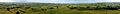
Panorama of the view from Puketapu Cairn overlooking Palmerston
